Ghantasala: A Town and Mandal in Krishna district
District → Krishna
State → Andhra Pradesh
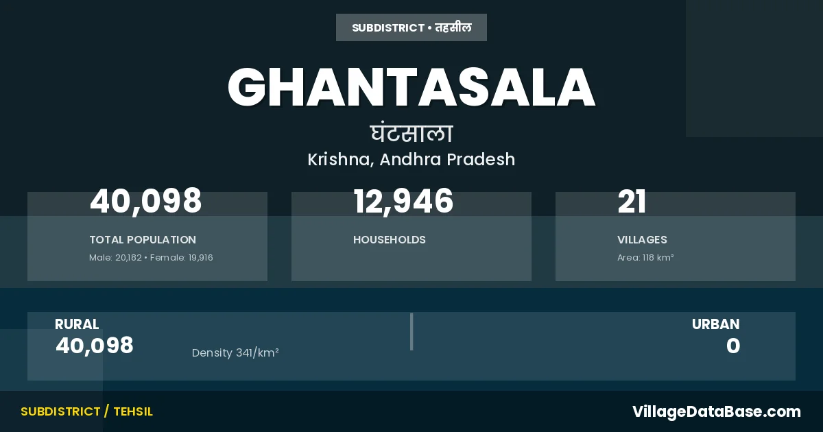
Ghantasala is a town and Mandal in the Krishna district of the Andhra Pradesh. In India, a Mandal is a subdivision of a district responsible for the administration and revenue collection of a specific area within the district. Mandals play a crucial role in the local governance structure, contributing significantly to the development and administration of their communities.
According to the 2011 census The total area of Ghantasala Mandal is 118 km², with a population of 40098 people. The population density is 341 inhabitants per square kilometre, and there are approximately 12946 houses in the sub district.
Ghantasala Mandal comprises about 21 villages. Below is a list of these villages along with information about their respective gram panchayats and the nearest town:
| # | Village Name | Gram Panchayat | Nearest Town |
|---|---|---|---|
| 1 | Birudugadda | Devarakota | Machilipatnam (30 km) |
| 2 | Bollapadu | Mallampalli | Machilipatnam (29 km) |
| 3 | Chilakalapudi | Chilakalapudi | Machilipatnam (30 km) |
| 4 | China Kallepalle | Chinakallepalli | Machilipatnam (38 km) |
| 5 | Chitturpu | Chiturpu | Machilipatnam (30 km) |
| 6 | Chitturu | Chitturu | Machilipatnam (20 km) |
| 7 | Daliparru | Daliparru | Machilipatnam (21 km) |
| 8 | Devarakota | Devarakota | Machilipatnam (25 km) |
| 9 | Elikala Kuduru | Devarakota | Machilipatnam (30 km) |
| 10 | Endakuduru | Yendakuduru | Machilipatnam (12 km) |
| 11 | Ghantasala | Ghantasala | Machilipatnam (26 km) |
| 12 | Kodali | Kodali | Machilipatnam (30 km) |
| 13 | Kothapalle | Kothapalli | Machilipatnam (38 km) |
| 14 | Lankapalle | Lankapalli | Machilipatnam (17 km) |
| 15 | Mallampalle | Mallampalli | Machilipatnam (30 km) |
| 16 | Pushadam | Pushadam | Machilipatnam (20 km) |
| 17 | Srikakulam | Atchampalem | Machilipatnam (39 km) |
| 18 | Tadepalle | Tadepalli | Machilipatnam (38 km) |
| 19 | Teluguraopalem | Teluguraopalem | Machilipatnam (32 km) |
| 20 | V Rudravaram | V Rudravaram | Machilipatnam (28 km) |
| 21 | Vemulapalle | Vemulapalli | Machilipatnam (39 km) |
The population is distributed between urban and rural areas as follows:
| Particulars | Rural | Urban | Total |
|---|---|---|---|
| Total Population | 40098 | 0 | 40098 |
| Male Population | 20182 | 0 | 20182 |
| Female Population | 19916 | 0 | 19916 | Population Density | 341 / km² | 341 / km² |
The distribution of households in the Ghantasala is:
| Rural Households | Urban Households | Total Households |
|---|---|---|
| 12946 | 0 | 12946 |
Q: What is Ghantasala?
A: Ghantasala is a town and in the Krishna district of the Andhra Pradesh.
Q: What is the total area of Ghantasala Mandal?
A: The total area of Ghantasala Mandal is 118 km².
Q: What is the population of Ghantasala Mandal according to the 2011 census?
A: According to the 2011 census, the population of Ghantasala Mandal is 40098.
Q: What is the population density of Ghantasala Mandal?
A: The population density of Ghantasala Mandal is 341 inhabitants per square kilometre.
Q: How many houses are there in Ghantasala Mandal?
A: There are approximately 12946 houses in Ghantasala Mandal.
Q: How many villages are there in Ghantasala Mandal?
A: There are about 21 villages in Ghantasala Mandal.
Q: Which is the largest village by population in Ghantasala Mandal?
A: The largest village by population in Ghantasala Mandal is Ghantasala, with 9248 people.
Q: Which is the smallest village by population in Ghantasala Mandal?
A: The smallest village by population in Ghantasala Mandal is Elikala Kuduru, with 0 people.
Q: Which is the largest village by area in Ghantasala Mandal?
A: The largest village by area in Ghantasala Mandal is Srikakulam, with 2924 km².
Q: Which is the smallest village by area in Ghantasala Mandal?
A: The smallest village by area in Ghantasala Mandal is Elikala Kuduru, with 67 km².
Q: What is the population distribution between urban and rural areas in Ghantasala Mandal?
A: The population distribution in Ghantasala Mandal is entirely rural, with a total rural population of 40098.
Q: What is the male population of Ghantasala Mandal?
A: The male population of Ghantasala Mandal is 20182.
Q: What is the female population of Ghantasala Mandal?
A: The female population of Ghantasala Mandal is 19916.
Q: How is the household distribution in Ghantasala Mandal?
A: The household distribution in Ghantasala Mandal is entirely rural, with a total of 12946 households.
Q: How many villages in Ghantasala Mandal have a population of less than 100?
A: There are 2 villages in Ghantasala Mandal with a population of less than 100.
Q: How many villages in Ghantasala Mandal have a population between 100 and 499?
A: There are 1 villages in Ghantasala Mandal with a population between 100 and 499.
Q: How many villages in Ghantasala Mandal have a population between 500 and 999?
A: There are 6 villages in Ghantasala Mandal with a population between 500 and 999.
Q: How many villages in Ghantasala Mandal have a population between 1000 and 1999?
A: There are 7 villages in Ghantasala Mandal with a population between 1000 and 1999.
Q: How many villages in Ghantasala Mandal have a population between 2000 and 2999?
A: There is 3 village in Ghantasala Mandal with a population between 2000 and 2999.
Q: How many villages in Ghantasala Mandal have a population of 5000 and above?
A: There is 2 village in Ghantasala Mandal with a population of 5000 and above.
| Total Population | Villages in Sub District Of Ghantasala |
|---|---|
| Less than 100 | 2 |
| 100-499 | 1 |
| 500-999 | 6 |
| 1000-1999 | 7 |
| 2000-2999 | 3 |
| 5000 And Above | 2 |