District → Prakasam
State → Andhra Pradesh
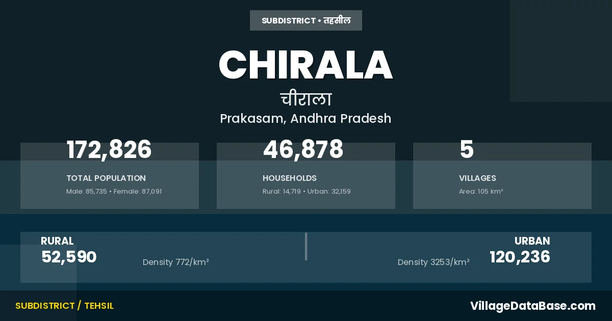
Chirala is a town and Mandal in the Prakasam district of the Andhra Pradesh. In India, a Mandal is a subdivision of a district responsible for the administration and revenue collection of a specific area within the district. Mandals play a crucial role in the local governance structure, contributing significantly to the development and administration of their communities.
According to the 2011 census The total area of Chirala Mandal is 105 km², with a population of 172826 people. The population density is 1,644 inhabitants per square kilometre, and there are approximately 46878 houses in the sub district.
Chirala Mandal comprises about 5 villages. Below is a list of these villages along with information about their respective gram panchayats and the nearest town:
| # | Village Name | Gram Panchayat | Nearest Town |
|---|---|---|---|
| 1 | Chirala | Chirala Nagar | Chirala |
| 2 | Gavinivari Palem | Devinuthala | Chirala (10 km) |
| 3 | Ipuru Palem | Burlavaripalem | Chirala (5 km) |
| 4 | Ipurupalem | Burlavaripalem | Chirala (5 km) |
| 5 | Wada | Epurupalem | Chirala (6 km) |
The population is distributed between urban and rural areas as follows:
| Particulars | Rural | Urban | Total |
|---|---|---|---|
| Total Population | 52590 | 120236 | 172826 |
| Male Population | 26550 | 59185 | 85735 |
| Female Population | 26040 | 61051 | 87091 | Population Density | 772 / km² | 3253 / km² | 1,644 / km² |
The distribution of households in the Chirala is:
| Rural Households | Urban Households | Total Households |
|---|---|---|
| 14719 | 32159 | 46878 |
Q: What is Chirala?
A: Chirala is a town and in the Prakasam district of the Andhra Pradesh.
Q: What is the total area of Chirala Mandal?
A: The total area of Chirala Mandal is 105 km².
Q: What is the population of Chirala Mandal according to the 2011 census?
A: According to the 2011 census, the population of Chirala Mandal is 172826.
Q: What is the population density of Chirala Mandal?
A: The population density of Chirala Mandal is 1,644 inhabitants per square kilometre.
Q: How many houses are there in Chirala Mandal?
A: There are approximately 46878 houses in Chirala Mandal.
Q: How many villages are there in Chirala Mandal?
A: There are about 5 villages in Chirala Mandal.
Q: Which is the largest village by population in Chirala Mandal?
A: The largest village by population in Chirala Mandal is Ipuru Palem, with 40482 people.
Q: Which is the smallest village by population in Chirala Mandal?
A: The smallest village by population in Chirala Mandal is Chirala, with 0 people.
Q: Which is the largest village by area in Chirala Mandal?
A: The largest village by area in Chirala Mandal is Ipuru Palem, with 3142 km².
Q: Which is the smallest village by area in Chirala Mandal?
A: The smallest village by area in Chirala Mandal is Chirala, with 0 km².
Q: What is the male population of Chirala Mandal?
A: The male population of Chirala Mandal is 85735.
Q: What is the female population of Chirala Mandal?
A: The female population of Chirala Mandal is 87091.
Q: How many villages in Chirala Mandal have a population of less than 100?
A: There are 2 villages in Chirala Mandal with a population of less than 100.
Q: How many villages in Chirala Mandal have a population of 5000 and above?
A: There is 3 village in Chirala Mandal with a population of 5000 and above.
| Total Population | Villages in Sub District Of Chirala |
|---|---|
| Less than 100 | 2 |
| 5000 And Above | 3 |