District → Prakasam
State → Andhra Pradesh
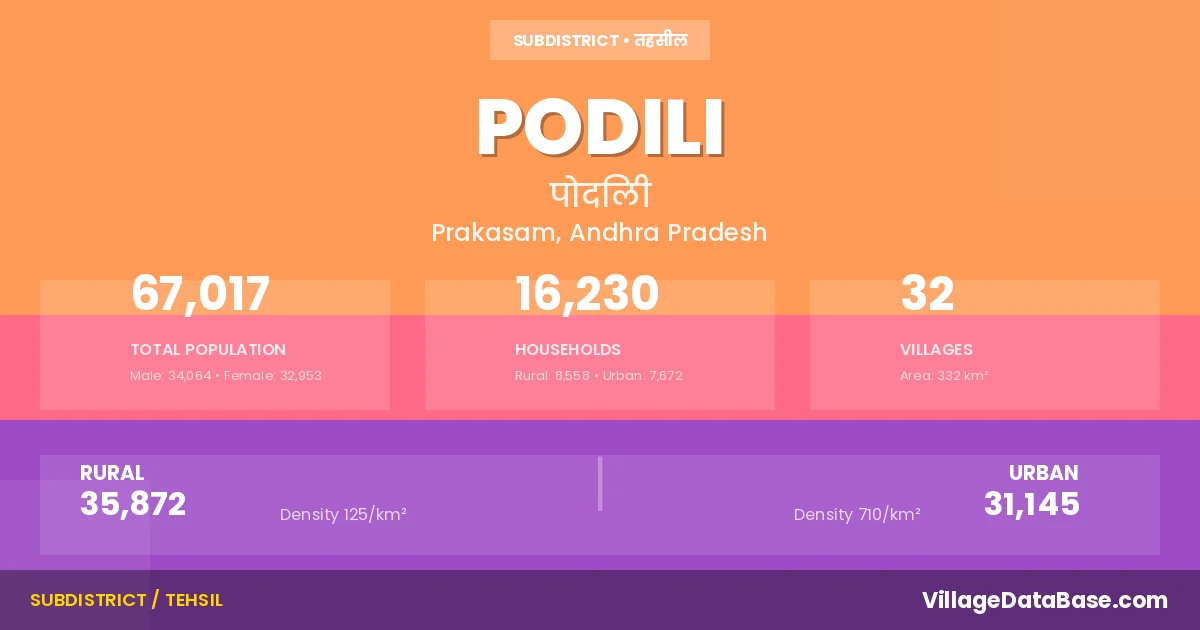
Podili is a town and Mandal in the Prakasam district of the Andhra Pradesh. In India, a Mandal is a subdivision of a district responsible for the administration and revenue collection of a specific area within the district. Mandals play a crucial role in the local governance structure, contributing significantly to the development and administration of their communities.
According to the 2011 census The total area of Podili Mandal is 332 km², with a population of 67017 people. The population density is 202 inhabitants per square kilometre, and there are approximately 16230 houses in the sub district.
Podili Mandal comprises about 32 villages. Below is a list of these villages along with information about their respective gram panchayats and the nearest town:
| # | Village Name | Gram Panchayat | Nearest Town |
|---|---|---|---|
| 1 | Akka Cheruvu | Akkacheruvu | Markapur (47 km) |
| 2 | Amudala Palle | Amudalapalli | Markapur (52 km) |
| 3 | Anna Varam | Annavaram | Ongole (46 km) |
| 4 | Chintagum Palle | Annavaram | Ongole (45 km) |
| 5 | Dasalla Palle | Kunchepalli | Ongole (63 km) |
| 6 | Dondleru | Kondayapalem | Markapur (28 km) |
| 7 | Egalapadu | Egalapadu | Markapur (60 km) |
| 8 | Jafala Puram | Kambhalapadu | Ongole (56 km) |
| 9 | Kambhalapadu | Kambhalapadu | Markapur (47 km) |
| 10 | Kesavabhotla Palem | Pamulapadu | Markapur (57 km) |
| 11 | Kondaya Palem | Kondayapalem | Markapur (27 km) |
| 12 | Kunchepalle | Kunchepalli | Ongole (60 km) |
| 13 | Lakshmi Puram | Talamalla | Ongole (42 km) |
| 14 | Madalavari Palem | Madalavaripalem | Markapur (37 km) |
| 15 | Mallavaram | Mallavaram | Markapur (44 km) |
| 16 | Muga Chinthala | Mugachintala | Markapur (28 km) |
| 17 | Nandi Palem | Nandipalem | Markapur (40 km) |
| 18 | Nimmavaram | Amudalapalli | Markapur (48 km) |
| 19 | Obulakka Palle | Obulakkapalli | Markapur (43 km) |
| 20 | Pamulapadu | Pamulapadu | Markapur (55 km) |
| 21 | Podili | Podili | Podili |
| 22 | Ramayana Kandrika | Madalavaripalem | Markapur (38 km) |
| 23 | Ramulaveedu | Amudalapalli | Markapur (53 km) |
| 24 | Salakanuthala | Kondayapalem | Markapur (28 km) |
| 25 | Sudanagunta | Sudanagunta | Markapur (48 km) |
| 26 | T Salluru | Yeluru | Ongole (36 km) |
| 27 | Teegadurthipadu | Amudalapalli | Ongole (46 km) |
| 28 | Thalamalla | Talamalla | Ongole (37 km) |
| 29 | Thummagunta | Thummagunta | Markapur (49 km) |
| 30 | Uppala Padu | Uppalapadu | Ongole (35 km) |
| 31 | Yeluru | Yeluru | Ongole (34 km) |
| 32 | Zuvvaleru | Juvvaleru | Markapur (45 km) |
The population is distributed between urban and rural areas as follows:
| Particulars | Rural | Urban | Total |
|---|---|---|---|
| Total Population | 35872 | 31145 | 67017 |
| Male Population | 18383 | 15681 | 34064 |
| Female Population | 17489 | 15464 | 32953 | Population Density | 125 / km² | 710 / km² | 202 / km² |
The distribution of households in the Podili is:
| Rural Households | Urban Households | Total Households |
|---|---|---|
| 8558 | 7672 | 16230 |
Q: What is Podili?
A: Podili is a town and in the Prakasam district of the Andhra Pradesh.
Q: What is the total area of Podili Mandal?
A: The total area of Podili Mandal is 332 km².
Q: What is the population of Podili Mandal according to the 2011 census?
A: According to the 2011 census, the population of Podili Mandal is 67017.
Q: What is the population density of Podili Mandal?
A: The population density of Podili Mandal is 202 inhabitants per square kilometre.
Q: How many houses are there in Podili Mandal?
A: There are approximately 16230 houses in Podili Mandal.
Q: How many villages are there in Podili Mandal?
A: There are about 32 villages in Podili Mandal.
Q: Which is the largest village by population in Podili Mandal?
A: The largest village by population in Podili Mandal is Kambhalapadu, with 4210 people.
Q: Which is the smallest village by population in Podili Mandal?
A: The smallest village by population in Podili Mandal is Lakshmi Puram, with 0 people.
Q: Which is the largest village by area in Podili Mandal?
A: The largest village by area in Podili Mandal is Sudanagunta, with 1889 km².
Q: Which is the smallest village by area in Podili Mandal?
A: The smallest village by area in Podili Mandal is Podili, with 0 km².
Q: What is the male population of Podili Mandal?
A: The male population of Podili Mandal is 34064.
Q: What is the female population of Podili Mandal?
A: The female population of Podili Mandal is 32953.
Q: How many villages in Podili Mandal have a population of less than 100?
A: There are 3 villages in Podili Mandal with a population of less than 100.
Q: How many villages in Podili Mandal have a population between 100 and 499?
A: There are 4 villages in Podili Mandal with a population between 100 and 499.
Q: How many villages in Podili Mandal have a population between 500 and 999?
A: There are 10 villages in Podili Mandal with a population between 500 and 999.
Q: How many villages in Podili Mandal have a population between 1000 and 1999?
A: There are 10 villages in Podili Mandal with a population between 1000 and 1999.
Q: How many villages in Podili Mandal have a population between 2000 and 2999?
A: There is 4 village in Podili Mandal with a population between 2000 and 2999.
Q: How many villages in Podili Mandal have a population between 4000 and 4999?
A: There is 1 village in Podili Mandal with a population between 4000 and 4999.
| Total Population | Villages in Sub District Of Podili |
|---|---|
| Less than 100 | 3 |
| 100-499 | 4 |
| 500-999 | 10 |
| 1000-1999 | 10 |
| 2000-2999 | 4 |
| 4000-4999 | 1 |