Atmakur: A Town and Mandal in Sri Potti Sriramulu Nellore district
District → Sri Potti Sriramulu Nellore
State → Andhra Pradesh
Atmakur is a town and Mandal in the Sri Potti Sriramulu Nellore district of the Andhra Pradesh. In India, a Mandal is a subdivision of a district responsible for the administration and revenue collection of a specific area within the district. Mandals play a crucial role in the local governance structure, contributing significantly to the development and administration of their communities.
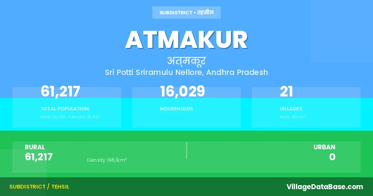
According to the 2011 census The total area of Atmakur Mandal is 312 km², with a population of 61217 people. The population density is 196 inhabitants per square kilometre, and there are approximately 16029 houses in the sub district.
Atmakur Mandal comprises about 21 villages. Below is a list of these villages along with information about their respective gram panchayats and the nearest town:
| # | Village Name | Gram Panchayat | Nearest Town |
|---|---|---|---|
| 1 | Aravedu | Aravedu | Nellore (41 km) |
| 2 | Atmakur | Nellore (55 km) | |
| 3 | Bandarupalle | Bandarupalli | Nellore (67 km) |
| 4 | Battepadu | Apparaopalem | Nellore (59 km) |
| 5 | Botikarlapadu | Padakandla | Nellore (80 km) |
| 6 | Boyila Chiruvella | Boyalachiruvella | Nellore (64 km) |
| 7 | Chiruvella Khandrika | Boyalachiruvella | Nellore (63 km) |
| 8 | Depuru | Depur | Nellore (63 km) |
| 9 | Gandlavedu | Padakandla | Nellore (83 km) |
| 10 | Jangalapalle | Nuvvurupadu | Nellore (61 km) |
| 11 | Kanupurupalle | Kanupurupalli | Nellore (65 km) |
| 12 | Karatampadu | Karatampadu | Nellore (66 km) |
| 13 | Mahimalur | Mahimalur | Nellore (65 km) |
| 14 | Nabbinagaram | Boyalachiruvella | Nellore (62 km) |
| 15 | Nagulapadu | Cherlo Yadavalli | Nellore (62 km) |
| 16 | Narampeta | Narampeta | Nellore (65 km) |
| 17 | Nellorepalem | Nellore (56 km) | |
| 18 | Nuvvurupadu | Nuvvurupadu | Nellore (58 km) |
| 19 | Padakandla | Padakandla | Nellore (77 km) |
| 20 | Pamidipadu | Pamidipadu | Nellore (57 km) |
| 21 | Vasili | Vasili | Nellore (45 km) |
The population is distributed between urban and rural areas as follows:
| Particulars | Rural | Urban | Total |
|---|---|---|---|
| Total Population | 61217 | 0 | 61217 |
| Male Population | 30790 | 0 | 30790 |
| Female Population | 30427 | 0 | 30427 | Population Density | 196 / km² | 196 / km² |
The distribution of households in the Atmakur is:
| Rural Households | Urban Households | Total Households |
|---|---|---|
| 16029 | 0 | 16029 |
Q: What is Atmakur?
A: Atmakur is a town and in the Sri Potti Sriramulu Nellore district of the Andhra Pradesh.
Q: What is the total area of Atmakur Mandal?
A: The total area of Atmakur Mandal is 312 km².
Q: What is the population of Atmakur Mandal according to the 2011 census?
A: According to the 2011 census, the population of Atmakur Mandal is 61217.
Q: What is the population density of Atmakur Mandal?
A: The population density of Atmakur Mandal is 196 inhabitants per square kilometre.
Q: How many houses are there in Atmakur Mandal?
A: There are approximately 16029 houses in Atmakur Mandal.
Q: How many villages are there in Atmakur Mandal?
A: There are about 21 villages in Atmakur Mandal.
Q: Which is the largest village by population in Atmakur Mandal?
A: The largest village by population in Atmakur Mandal is Atmakur, with 29419 people.
Q: Which is the smallest village by population in Atmakur Mandal?
A: The smallest village by population in Atmakur Mandal is Nabbinagaram, with 272 people.
Q: Which is the largest village by area in Atmakur Mandal?
A: The largest village by area in Atmakur Mandal is Atmakur, with 4756 km².
Q: Which is the smallest village by area in Atmakur Mandal?
A: The smallest village by area in Atmakur Mandal is Jangalapalle, with 134 km².
Q: What is the population distribution between urban and rural areas in Atmakur Mandal?
A: The population distribution in Atmakur Mandal is entirely rural, with a total rural population of 61217.
Q: What is the male population of Atmakur Mandal?
A: The male population of Atmakur Mandal is 30790.
Q: What is the female population of Atmakur Mandal?
A: The female population of Atmakur Mandal is 30427.
Q: How is the household distribution in Atmakur Mandal?
A: The household distribution in Atmakur Mandal is entirely rural, with a total of 16029 households.
Q: How many villages in Atmakur Mandal have a population between 100 and 499?
A: There are 5 villages in Atmakur Mandal with a population between 100 and 499.
Q: How many villages in Atmakur Mandal have a population between 500 and 999?
A: There are 3 villages in Atmakur Mandal with a population between 500 and 999.
Q: How many villages in Atmakur Mandal have a population between 1000 and 1999?
A: There are 7 villages in Atmakur Mandal with a population between 1000 and 1999.
Q: How many villages in Atmakur Mandal have a population between 2000 and 2999?
A: There is 3 village in Atmakur Mandal with a population between 2000 and 2999.
Q: How many villages in Atmakur Mandal have a population between 4000 and 4999?
A: There is 1 village in Atmakur Mandal with a population between 4000 and 4999.
Q: How many villages in Atmakur Mandal have a population of 5000 and above?
A: There is 2 village in Atmakur Mandal with a population of 5000 and above.
| Total Population | Villages in Sub District Of Atmakur |
|---|---|
| 100-499 | 5 |
| 500-999 | 3 |
| 1000-1999 | 7 |
| 2000-2999 | 3 |
| 4000-4999 | 1 |
| 5000 And Above | 2 |