Ojili: A Town and Mandal in Sri Potti Sriramulu Nellore district
District → Sri Potti Sriramulu Nellore
State → Andhra Pradesh
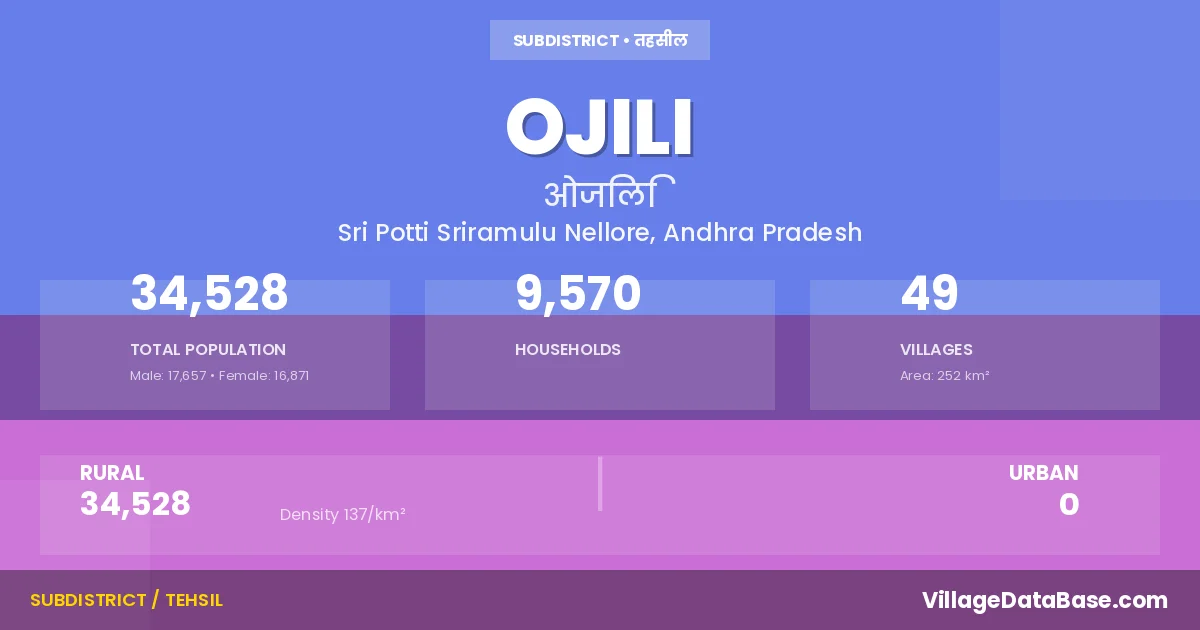
Ojili is a town and Mandal in the Sri Potti Sriramulu Nellore district of the Andhra Pradesh. In India, a Mandal is a subdivision of a district responsible for the administration and revenue collection of a specific area within the district. Mandals play a crucial role in the local governance structure, contributing significantly to the development and administration of their communities.
According to the 2011 census The total area of Ojili Mandal is 252 km², with a population of 34528 people. The population density is 137 inhabitants per square kilometre, and there are approximately 9570 houses in the sub district.
Ojili Mandal comprises about 49 villages. Below is a list of these villages along with information about their respective gram panchayats and the nearest town:
| # | Village Name | Gram Panchayat | Nearest Town |
|---|---|---|---|
| 1 | Acharlaparlapalle | Konda Valli Padu | Gudur (23 km) |
| 2 | Arimanipadu | Arimani Padu | Gudur (19 km) |
| 3 | Athivaram | Athivaram | Gudur (35 km) |
| 4 | Athivaram Kothapalem | Athivaram | Gudur (34 km) |
| 5 | Bandarugunta | Ravi Padu | Gudur (25 km) |
| 6 | Bhathalapuram | Venkata Reddy Palem | Gudur (28 km) |
| 7 | Bhatlakanupuru | Batlakanupuru | Gudur (30 km) |
| 8 | Bhuvanagiripalem | Bhuvanagiri Pallem | Gudur (24 km) |
| 9 | Chillamanichenu | Chilla Manu Chenu | Gudur (22 km) |
| 10 | Enuguwada | Kundam | Gudur (32 km) |
| 11 | Garudagunta Agraharam | Gradda Gunta | Gudur (30 km) |
| 12 | Graddagunta | Gradda Gunta | Gudur (30 km) |
| 13 | Gurramkonda | Gurram Konda | Gudur (22 km) |
| 14 | Inugunta | Inugunta | Gudur (26 km) |
| 15 | Josyulavari Khandrika | Gradda Gunta | Gudur (28 km) |
| 16 | Karaballavolu | Karaballavolu | Gudur (33 km) |
| 17 | Karjamedu | Gurram Konda | Gudur (22 km) |
| 18 | Karuru | Athivaram | Gudur (34 km) |
| 19 | Kondavallipadu | Konda Valli Padu | Gudur (26 km) |
| 20 | Kotha Cheruvu | Kotha Cheruvu | Gudur (34 km) |
| 21 | Kothapeta | Punnepalli | Gudur (25 km) |
| 22 | Kundam | Kundam | Gudur (27 km) |
| 23 | Kurugonda | Kurugonda | Gudur (28 km) |
| 24 | L J Kattubadi | Ravi Padu | Gudur (28 km) |
| 25 | Lingareddipalle | Ravi Padu | Venkatagiri (18 km) |
| 26 | Machavaram | Machavaram | Gudur (32 km) |
| 27 | Manamala | Mana Mala | Gudur (24 km) |
| 28 | Manavali | Manavali | Gudur (35 km) |
| 29 | Mummayapalem | Mummaya Palem | Gudur (33 km) |
| 30 | Nemallapudi | Nemalla Pudu | Gudur (30 km) |
| 31 | Ojili | Ozili | Gudur (26 km) |
| 32 | Palempadu | Inugunta | Gudur (25 km) |
| 33 | Peda Pariya | Pedda Pariya | Gudur (18 km) |
| 34 | Pinapariyapadu | Chilla Manu Chenu | Gudur (25 km) |
| 35 | Polipadu | Bhuvanagiri Pallem | Gudur (22 km) |
| 36 | Punnepalle | Punnepalli | Gudur (26 km) |
| 37 | Rachapalem | Racha Palem | Gudur (29 km) |
| 38 | Raghavareddipalem | Chilla Manu Chenu | Gudur (30 km) |
| 39 | Rajanagaram | Inugunta | Gudur (26 km) |
| 40 | Rajupalem | Venkata Reddy Palem | Gudur (18 km) |
| 41 | Rangarajasamudram | Inugunta | Gudur (26 km) |
| 42 | Ravipadu | Ravi Padu | Gudur (27 km) |
| 43 | Rudrayapalem | Konda Valli Padu | Gudur (25 km) |
| 44 | Saguturu | Saguturu | Gudur (25 km) |
| 45 | Thirumalapudi | Thirumala Pudi | Gudur (30 km) |
| 46 | Vakativari Khandrika | Venkata Reddy Palem | Gudur (24 km) |
| 47 | Veerlagunapadu | Saguturu | Gudur (25 km) |
| 48 | Venkatareddipalem | Venkata Reddy Palem | Gudur (28 km) |
| 49 | Vijayanellore | Venkata Reddy Palem | Gudur (22 km) |
The population is distributed between urban and rural areas as follows:
| Particulars | Rural | Urban | Total |
|---|---|---|---|
| Total Population | 34528 | 0 | 34528 |
| Male Population | 17657 | 0 | 17657 |
| Female Population | 16871 | 0 | 16871 | Population Density | 137 / km² | 137 / km² |
The distribution of households in the Ojili is:
| Rural Households | Urban Households | Total Households |
|---|---|---|
| 9570 | 0 | 9570 |
Q: What is Ojili?
A: Ojili is a town and in the Sri Potti Sriramulu Nellore district of the Andhra Pradesh.
Q: What is the total area of Ojili Mandal?
A: The total area of Ojili Mandal is 252 km².
Q: What is the population of Ojili Mandal according to the 2011 census?
A: According to the 2011 census, the population of Ojili Mandal is 34528.
Q: What is the population density of Ojili Mandal?
A: The population density of Ojili Mandal is 137 inhabitants per square kilometre.
Q: How many houses are there in Ojili Mandal?
A: There are approximately 9570 houses in Ojili Mandal.
Q: How many villages are there in Ojili Mandal?
A: There are about 49 villages in Ojili Mandal.
Q: Which is the largest village by population in Ojili Mandal?
A: The largest village by population in Ojili Mandal is Kurugonda, with 3410 people.
Q: Which is the smallest village by population in Ojili Mandal?
A: The smallest village by population in Ojili Mandal is Athivaram Kothapalem, with 0 people.
Q: Which is the largest village by area in Ojili Mandal?
A: The largest village by area in Ojili Mandal is Athivaram, with 1726 km².
Q: Which is the smallest village by area in Ojili Mandal?
A: The smallest village by area in Ojili Mandal is L J Kattubadi, with 0 km².
Q: What is the population distribution between urban and rural areas in Ojili Mandal?
A: The population distribution in Ojili Mandal is entirely rural, with a total rural population of 34528.
Q: What is the male population of Ojili Mandal?
A: The male population of Ojili Mandal is 17657.
Q: What is the female population of Ojili Mandal?
A: The female population of Ojili Mandal is 16871.
Q: How is the household distribution in Ojili Mandal?
A: The household distribution in Ojili Mandal is entirely rural, with a total of 9570 households.
Q: How many villages in Ojili Mandal have a population of less than 100?
A: There are 7 villages in Ojili Mandal with a population of less than 100.
Q: How many villages in Ojili Mandal have a population between 100 and 499?
A: There are 16 villages in Ojili Mandal with a population between 100 and 499.
Q: How many villages in Ojili Mandal have a population between 500 and 999?
A: There are 13 villages in Ojili Mandal with a population between 500 and 999.
Q: How many villages in Ojili Mandal have a population between 1000 and 1999?
A: There are 10 villages in Ojili Mandal with a population between 1000 and 1999.
Q: How many villages in Ojili Mandal have a population between 2000 and 2999?
A: There is 2 village in Ojili Mandal with a population between 2000 and 2999.
Q: How many villages in Ojili Mandal have a population between 3000 and 3999?
A: There is 1 village in Ojili Mandal with a population between 3000 and 3999.
| Total Population | Villages in Sub District Of Ojili |
|---|---|
| Less than 100 | 7 |
| 100-499 | 16 |
| 500-999 | 13 |
| 1000-1999 | 10 |
| 2000-2999 | 2 |
| 3000-3999 | 1 |