District → Srikakulam
State → Andhra Pradesh
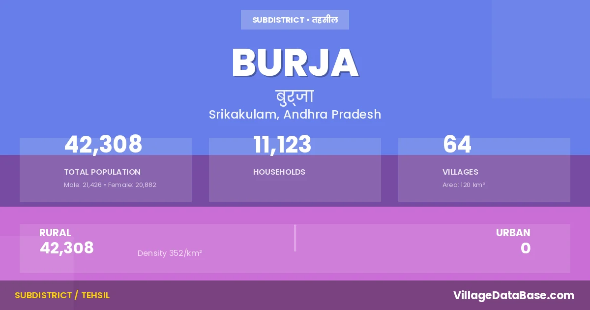
Burja is a town and Mandal in the Srikakulam district of the Andhra Pradesh. In India, a Mandal is a subdivision of a district responsible for the administration and revenue collection of a specific area within the district. Mandals play a crucial role in the local governance structure, contributing significantly to the development and administration of their communities.
According to the 2011 census The total area of Burja Mandal is 120 km², with a population of 42308 people. The population density is 352 inhabitants per square kilometre, and there are approximately 11123 houses in the sub district.
Burja Mandal comprises about 64 villages. Below is a list of these villages along with information about their respective gram panchayats and the nearest town:
| # | Village Name | Gram Panchayat | Nearest Town |
|---|---|---|---|
| 1 | Adduripeta | T D R Rajupeta | Amadalavalasa (25 km) |
| 2 | Ahobalacharyula Peta | Uppinivalasa | Amadalavalasa (11 km) |
| 3 | Allena | Allena | Amadalavalasa (37 km) |
| 4 | Annampeta | Annampeta | Amadalavalasa (24 km) |
| 5 | Appalapatnayakuni Peta | A P Peta | Amadalavalasa (18 km) |
| 6 | Boddapadu | Vykuntapuram | Amadalavalasa (28 km) |
| 7 | Bodlapadu | Annampeta | Amadalavalasa (9 km) |
| 8 | Boragavalasa | Koaragam | Amadalavalasa (7 km) |
| 9 | Burja | Burja | Amadalavalasa (25 km) |
| 10 | Chalikam | Kalaparthi | Amadalavalasa (10 km) |
| 11 | Cheedivalasa | Ceedivalasa | Amadalavalasa (15 km) |
| 12 | Devanapuram | T D R Rajupeta | Amadalavalasa (16 km) |
| 13 | Donkalapartha | Donkalapartha | Amadalavalasa (30 km) |
| 14 | Gangabhagiradhi Puram | Allena | Amadalavalasa (35 km) |
| 15 | Gangampeta | Ceedivalasa | Amadalavalasa (15 km) |
| 16 | Gopalakrishnarangarayapuram | Kalaparthi | Amadalavalasa (10 km) |
| 17 | Gopidevipeta | A P Peta | Amadalavalasa (23 km) |
| 18 | Gudigeddavenkata Puram | Annampeta | Amadalavalasa (7 km) |
| 19 | Guttavalli | Guttavelli | Amadalavalasa (18 km) |
| 20 | Haripurampallapuram | Donkalapartha | Amadalavalasa (28 km) |
| 21 | Issadivalasa | A P Peta | Amadalavalasa (20 km) |
| 22 | Jagannadhapuram | Peddapeta | Amadalavalasa (33 km) |
| 23 | Jangalapadu | Annampeta | Amadalavalasa (28 km) |
| 24 | Jogipaduvenkata Puram | P L Devipeta | Amadalavalasa (27 km) |
| 25 | Kakandyam | Mamidivalasa | Amadalavalasa (29 km) |
| 26 | Kalaparthi | Kalaparthi | Amadalavalasa (10 km) |
| 27 | Kantlam | Kantlam | Amadalavalasa (16 km) |
| 28 | Kilantra | Allena | Amadalavalasa (35 km) |
| 29 | Kollivalasa | Kollivalasa | Amadalavalasa (12 km) |
| 30 | Kondapeta | Peddapeta | Amadalavalasa (25 km) |
| 31 | Koragam | Koaragam | Amadalavalasa (7 km) |
| 32 | Korikanakurmiraja Puram | A P Peta | Amadalavalasa (17 km) |
| 33 | Kothavalasa | Palavalasa | Amadalavalasa (26 km) |
| 34 | Labham | Labham | Amadalavalasa (16 km) |
| 35 | Lakkupuram | Lakkupuram | Amadalavalasa (26 km) |
| 36 | Lankam | Chinalankam | Amadalavalasa (20 km) |
| 37 | Latchayyapeta | Kantlam | Amadalavalasa (10 km) |
| 38 | Mahajanamvaripeta | Uppinivalasa | Amadalavalasa (10 km) |
| 39 | Mamidivalasa | Mamidivalasa | Amadalavalasa (28 km) |
| 40 | Marripadu | Palavalasa | Amadalavalasa (25 km) |
| 41 | Masenaputhi | Annampeta | Amadalavalasa (27 km) |
| 42 | Narendrapuram | P L Devipeta | Amadalavalasa (16 km) |
| 43 | Neeladevipuram | Neeladevipuram | Amadalavalasa (16 km) |
| 44 | Neelakantapuram | T D R Rajupeta | Amadalavalasa (16 km) |
| 45 | Neelapuram | Peddapeta | Amadalavalasa (25 km) |
| 46 | Palavalasa | Palavalasa | Amadalavalasa (23 km) |
| 47 | Paravasturamanna Peta | Palavalasa | Amadalavalasa (25 km) |
| 48 | Peddapeta | Peddapeta | Amadalavalasa (22 km) |
| 49 | Pendyalalakshimidevipeta | P L Devipeta | Amadalavalasa (18 km) |
| 50 | Sankurada | Kollivalasa | Amadalavalasa (17 km) |
| 51 | Singannapalem | Singannapalem | Amadalavalasa (12 km) |
| 52 | Somidavalasa | P L Devipeta | Amadalavalasa (20 km) |
| 53 | Sundarayyapeta | Koaragam | Amadalavalasa (7 km) |
| 54 | T V Ramabhadra Raju Peta | T D R Rajupeta | Amadalavalasa (15 km) |
| 55 | Thimadam | Annampeta | Amadalavalasa (25 km) |
| 56 | Thotavada | Thotavada | Amadalavalasa (15 km) |
| 57 | Thuddali | Donkalapartha | Amadalavalasa (29 km) |
| 58 | Turupuramabhadrarajupeta | Thotavada | Amadalavalasa (16 km) |
| 59 | Uppinivalasa | Uppinivalasa | Amadalavalasa (10 km) |
| 60 | Vandra | Allena | Amadalavalasa (26 km) |
| 61 | Vavam | Vavam | Amadalavalasa (25 km) |
| 62 | Vopivadavenkam Peta | O V Peta | Amadalavalasa (13 km) |
| 63 | Vykuntapuram | Vykuntapuram | Amadalavalasa (8 km) |
| 64 | Yetivoddupartha | Donkalapartha | Amadalavalasa (35 km) |
The population is distributed between urban and rural areas as follows:
| Particulars | Rural | Urban | Total |
|---|---|---|---|
| Total Population | 42308 | 0 | 42308 |
| Male Population | 21426 | 0 | 21426 |
| Female Population | 20882 | 0 | 20882 | Population Density | 352 / km² | 352 / km² |
The distribution of households in the Burja is:
| Rural Households | Urban Households | Total Households |
|---|---|---|
| 11123 | 0 | 11123 |
Q: What is Burja?
A: Burja is a town and in the Srikakulam district of the Andhra Pradesh.
Q: What is the total area of Burja Mandal?
A: The total area of Burja Mandal is 120 km².
Q: What is the population of Burja Mandal according to the 2011 census?
A: According to the 2011 census, the population of Burja Mandal is 42308.
Q: What is the population density of Burja Mandal?
A: The population density of Burja Mandal is 352 inhabitants per square kilometre.
Q: How many houses are there in Burja Mandal?
A: There are approximately 11123 houses in Burja Mandal.
Q: How many villages are there in Burja Mandal?
A: There are about 64 villages in Burja Mandal.
Q: Which is the largest village by population in Burja Mandal?
A: The largest village by population in Burja Mandal is Burja, with 3046 people.
Q: Which is the smallest village by population in Burja Mandal?
A: The smallest village by population in Burja Mandal is Devanapuram, with 0 people.
Q: Which is the largest village by area in Burja Mandal?
A: The largest village by area in Burja Mandal is Thotavada, with 513 km².
Q: Which is the smallest village by area in Burja Mandal?
A: The smallest village by area in Burja Mandal is Vandra, with 28 km².
Q: What is the population distribution between urban and rural areas in Burja Mandal?
A: The population distribution in Burja Mandal is entirely rural, with a total rural population of 42308.
Q: What is the male population of Burja Mandal?
A: The male population of Burja Mandal is 21426.
Q: What is the female population of Burja Mandal?
A: The female population of Burja Mandal is 20882.
Q: How is the household distribution in Burja Mandal?
A: The household distribution in Burja Mandal is entirely rural, with a total of 11123 households.
Q: How many villages in Burja Mandal have a population of less than 100?
A: There are 17 villages in Burja Mandal with a population of less than 100.
Q: How many villages in Burja Mandal have a population between 100 and 499?
A: There are 13 villages in Burja Mandal with a population between 100 and 499.
Q: How many villages in Burja Mandal have a population between 500 and 999?
A: There are 19 villages in Burja Mandal with a population between 500 and 999.
Q: How many villages in Burja Mandal have a population between 1000 and 1999?
A: There are 12 villages in Burja Mandal with a population between 1000 and 1999.
Q: How many villages in Burja Mandal have a population between 2000 and 2999?
A: There is 2 village in Burja Mandal with a population between 2000 and 2999.
Q: How many villages in Burja Mandal have a population between 3000 and 3999?
A: There is 1 village in Burja Mandal with a population between 3000 and 3999.
| Total Population | Villages in Sub District Of Burja |
|---|---|
| Less than 100 | 17 |
| 100-499 | 13 |
| 500-999 | 19 |
| 1000-1999 | 12 |
| 2000-2999 | 2 |
| 3000-3999 | 1 |