Jalumuru: A Town and Mandal in Srikakulam district
District → Srikakulam
State → Andhra Pradesh
Jalumuru is a town and Mandal in the Srikakulam district of the Andhra Pradesh. In India, a Mandal is a subdivision of a district responsible for the administration and revenue collection of a specific area within the district. Mandals play a crucial role in the local governance structure, contributing significantly to the development and administration of their communities.
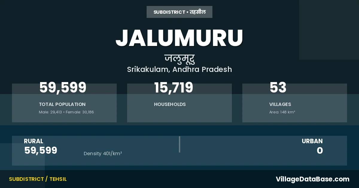
According to the 2011 census The total area of Jalumuru Mandal is 148 km², with a population of 59599 people. The population density is 401 inhabitants per square kilometre, and there are approximately 15719 houses in the sub district.
Jalumuru Mandal comprises about 53 villages. Below is a list of these villages along with information about their respective gram panchayats and the nearest town:
| # | Village Name | Gram Panchayat | Nearest Town |
|---|---|---|---|
| 1 | Akkurada | Akkurada | Amadalavalasa (38 km) |
| 2 | Allada | Allada | Amadalavalasa (33 km) |
| 3 | Alladapeta | Alladapea | Amadalavalasa (33 km) |
| 4 | Andhavaram | Andhavaram | Amadalavalasa (32 km) |
| 5 | Annupuram | Karakavalasa | Amadalavalasa (40 km) |
| 6 | Atchutapuram | Atchyuthapuram | Amadalavalasa (35 km) |
| 7 | Basivada | Basivada | Amadalavalasa (20 km) |
| 8 | Boddapadu | Bodapadu | Amadalavalasa (32 km) |
| 9 | Chennayavalasa | Chennaiahvalasa | Amadalavalasa (23 km) |
| 10 | Chinadugam | Chinadugam | Amadalavalasa (21 km) |
| 11 | Darivada | Darivada | Amadalavalasa (29 km) |
| 12 | Domalapalle | Nagarakatakam | Amadalavalasa (40 km) |
| 13 | Dompaka | Suravaram | Amadalavalasa (36 km) |
| 14 | Edulavalasa | Basivada | Amadalavalasa (21 km) |
| 15 | Garinivalasa | Marrivalasa | Amadalavalasa (38 km) |
| 16 | Goliyaputti | Rana | Amadalavalasa (27 km) |
| 17 | Gotivada | Gotivada | Amadalavalasa (33 km) |
| 18 | Guggili | Guggili | Amadalavalasa (17 km) |
| 19 | Gunduvalasa | Guggili | Amadalavalasa (29 km) |
| 20 | Jalumuru | Hussainpuram | Amadalavalasa (25 km) |
| 21 | Jaminivalasa | Marrivalasa | Amadalavalasa (38 km) |
| 22 | Jonanki | Jonanki | Amadalavalasa (29 km) |
| 23 | Karakavalasa | Karakavalasa | Amadalavalasa (40 km) |
| 24 | Karavanja | Karavanja | Amadalavalasa (28 km) |
| 25 | Komanapalle | Komanapalle | Amadalavalasa (33 km) |
| 26 | Kondapolavalasa | Kondapolavalasa | Amadalavalasa (33 km) |
| 27 | Kotturu | Pagodu | Amadalavalasa (29 km) |
| 28 | Kurmanadhapuram | Kurmanadhapuram | Amadalavalasa (38 km) |
| 29 | Lingalavalasa | Challavanipeta | Amadalavalasa (23 km) |
| 30 | Mahammadpuram | Gotivada | Amadalavalasa (33 km) |
| 31 | Makivalasa | Marrivalasa | Amadalavalasa (38 km) |
| 32 | Marrivalasa | Marrivalasa | Amadalavalasa (38 km) |
| 33 | Mohiddinpuram | Akkurada | Amadalavalasa (33 km) |
| 34 | Mukhalingam | Sri Mukhalingam | Amadalavalasa (38 km) |
| 35 | Nagarikatakam | Nagarakatakam | Amadalavalasa (35 km) |
| 36 | Pagodu | Pagodu | Amadalavalasa (28 km) |
| 37 | Parlam | Parlam | Amadalavalasa (28 km) |
| 38 | Peddadugam | Peddadugam | Amadalavalasa (21 km) |
| 39 | Ramayyavalasa | Ramaiahvalasa | Amadalavalasa (24 km) |
| 40 | Rana | Rana | Amadalavalasa (21 km) |
| 41 | Ravipadu | Ravipadu | Amadalavalasa (21 km) |
| 42 | Srimannarayana Puram | Marrivalasa | Amadalavalasa (38 km) |
| 43 | Subrahamanya Puram | Subrahmanyapuram | Amadalavalasa (30 km) |
| 44 | Suravaram | Suravaram | Amadalavalasa (33 km) |
| 45 | Syrigam | Syrigam | Amadalavalasa (28 km) |
| 46 | Talatariya | Talatariya | Amadalavalasa (29 km) |
| 47 | Tallavalasa | Guggili | Amadalavalasa (27 km) |
| 48 | Tekkalipadu | Tekkalipadu | Amadalavalasa (21 km) |
| 49 | Timadam | Timadam | Amadalavalasa (38 km) |
| 50 | Velusoda | Pagodu | Amadalavalasa (28 km) |
| 51 | Venkatapuram | Venkatapuram | Amadalavalasa (31 km) |
| 52 | Yelamanchili | Yelamanchili | Amadalavalasa (31 km) |
| 53 | Yenetikothuru | Ravipadu | Amadalavalasa (20 km) |
The population is distributed between urban and rural areas as follows:
| Particulars | Rural | Urban | Total |
|---|---|---|---|
| Total Population | 59599 | 0 | 59599 |
| Male Population | 29413 | 0 | 29413 |
| Female Population | 30186 | 0 | 30186 | Population Density | 401 / km² | 401 / km² |
The distribution of households in the Jalumuru is:
| Rural Households | Urban Households | Total Households |
|---|---|---|
| 15719 | 0 | 15719 |
Q: What is Jalumuru?
A: Jalumuru is a town and in the Srikakulam district of the Andhra Pradesh.
Q: What is the total area of Jalumuru Mandal?
A: The total area of Jalumuru Mandal is 148 km².
Q: What is the population of Jalumuru Mandal according to the 2011 census?
A: According to the 2011 census, the population of Jalumuru Mandal is 59599.
Q: What is the population density of Jalumuru Mandal?
A: The population density of Jalumuru Mandal is 401 inhabitants per square kilometre.
Q: How many houses are there in Jalumuru Mandal?
A: There are approximately 15719 houses in Jalumuru Mandal.
Q: How many villages are there in Jalumuru Mandal?
A: There are about 53 villages in Jalumuru Mandal.
Q: Which is the largest village by population in Jalumuru Mandal?
A: The largest village by population in Jalumuru Mandal is Lingalavalasa, with 4553 people.
Q: Which is the smallest village by population in Jalumuru Mandal?
A: The smallest village by population in Jalumuru Mandal is Mohiddinpuram, with 0 people.
Q: Which is the largest village by area in Jalumuru Mandal?
A: The largest village by area in Jalumuru Mandal is Jalumuru, with 1444 km².
Q: Which is the smallest village by area in Jalumuru Mandal?
A: The smallest village by area in Jalumuru Mandal is Edulavalasa, with 44 km².
Q: What is the population distribution between urban and rural areas in Jalumuru Mandal?
A: The population distribution in Jalumuru Mandal is entirely rural, with a total rural population of 59599.
Q: What is the male population of Jalumuru Mandal?
A: The male population of Jalumuru Mandal is 29413.
Q: What is the female population of Jalumuru Mandal?
A: The female population of Jalumuru Mandal is 30186.
Q: How is the household distribution in Jalumuru Mandal?
A: The household distribution in Jalumuru Mandal is entirely rural, with a total of 15719 households.
Q: How many villages in Jalumuru Mandal have a population of less than 100?
A: There are 4 villages in Jalumuru Mandal with a population of less than 100.
Q: How many villages in Jalumuru Mandal have a population between 100 and 499?
A: There are 12 villages in Jalumuru Mandal with a population between 100 and 499.
Q: How many villages in Jalumuru Mandal have a population between 500 and 999?
A: There are 13 villages in Jalumuru Mandal with a population between 500 and 999.
Q: How many villages in Jalumuru Mandal have a population between 1000 and 1999?
A: There are 18 villages in Jalumuru Mandal with a population between 1000 and 1999.
Q: How many villages in Jalumuru Mandal have a population between 2000 and 2999?
A: There is 3 village in Jalumuru Mandal with a population between 2000 and 2999.
Q: How many villages in Jalumuru Mandal have a population between 3000 and 3999?
A: There is 2 village in Jalumuru Mandal with a population between 3000 and 3999.
Q: How many villages in Jalumuru Mandal have a population between 4000 and 4999?
A: There is 1 village in Jalumuru Mandal with a population between 4000 and 4999.
| Total Population | Villages in Sub District Of Jalumuru |
|---|---|
| Less than 100 | 4 |
| 100-499 | 12 |
| 500-999 | 13 |
| 1000-1999 | 18 |
| 2000-2999 | 3 |
| 3000-3999 | 2 |
| 4000-4999 | 1 |