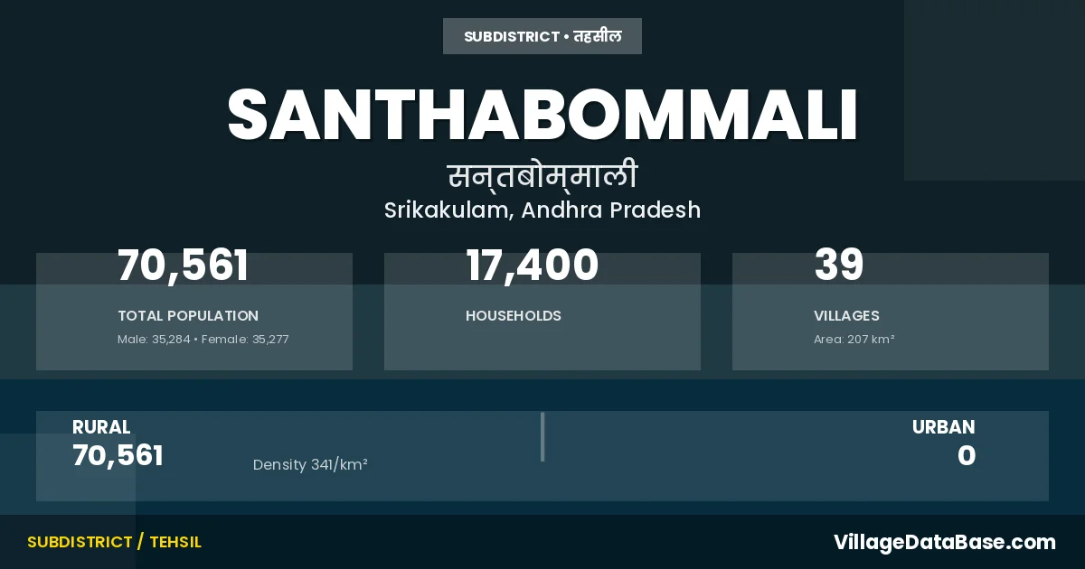
Santhabommali: A Town and Mandal in Srikakulam district
District → Srikakulam
State → Andhra Pradesh
Santhabommali is a town and Mandal in the Srikakulam district of the Andhra Pradesh. In India, a Mandal is a subdivision of a district responsible for the administration and revenue collection of a specific area within the district. Mandals play a crucial role in the local governance structure, contributing significantly to the development and administration of their communities.
According to the 2011 census The total area of Santhabommali Mandal is 207 km², with a population of 70561 people. The population density is 341 inhabitants per square kilometre, and there are approximately 17400 houses in the sub district.
Santhabommali Mandal comprises about 39 villages. Below is a list of these villages along with information about their respective gram panchayats and the nearest town:
| # | Village Name | Gram Panchayat | Nearest Town |
|---|---|---|---|
| 1 | Akasalakkavaram | Akakslakkavaram | Palasa Kasibugga (39 km) |
| 2 | Antlavaram | Santhabommali | Palasa Kasibugga (39 km) |
| 3 | Arikivalasa | Arikavalasa | Palasa Kasibugga (33 km) |
| 4 | Bhavanapadu Madyapeta | Bhavanapadu | Palasa Kasibugga (46 km) |
| 5 | Borubhadra | Borubhadra | Palasa Kasibugga (44 km) |
| 6 | Brundavanam | Kotapadu | Palasa Kasibugga (33 km) |
| 7 | Chinnatungam | Chinatungam | Palasa Kasibugga (35 km) |
| 8 | Dandugopalapuram | Chatlathandra | Palasa Kasibugga (34 km) |
| 9 | Godalam | Borubhadra | Palasa Kasibugga (47 km) |
| 10 | Govindapuram | Govindhapuram | Palasa Kasibugga (46 km) |
| 11 | Ijjuvaram | Ijjuvaram | Palasa Kasibugga (31 km) |
| 12 | Jonnalapadu | Govindhapuram | Palasa Kasibugga (40 km) |
| 13 | Kakarapalle | Kakarapalli | Palasa Kasibugga (45 km) |
| 14 | Kapugodeyavalasa | Kapugodayavalasa | Palasa Kasibugga (39 km) |
| 15 | Kaseepuram | Kotapadu | Palasa Kasibugga (34 km) |
| 16 | Khaspanaupada | Kaspanaupada | Palasa Kasibugga (34 km) |
| 17 | Kollipadu | Kollipadu | Palasa Kasibugga (49 km) |
| 18 | Kotapadu | Kotapadu | Palasa Kasibugga (35 km) |
| 19 | Kurmanadhapuram | Kaspanaupada | Palasa Kasibugga (35 km) |
| 20 | Lakkivalasa | Lakkivalasa | Palasa Kasibugga (50 km) |
| 21 | Malagam | Malagam | Palasa Kasibugga (47 km) |
| 22 | Marripadu | Marripadu | Palasa Kasibugga (35 km) |
| 23 | Maruvada | Maruvada | Palasa Kasibugga (51 km) |
| 24 | Meghavaram | Meghavaram | Palasa Kasibugga (52 km) |
| 25 | Narasapuram | Narasapuram | Palasa Kasibugga (40 km) |
| 26 | Palathalagam | Palatalagam | Palasa Kasibugga (47 km) |
| 27 | Pedatungam | Chinatungam | Palasa Kasibugga (34 km) |
| 28 | Pothunaidupeta | Hanumanthu Naidu Peta | Palasa Kasibugga (36 km) |
| 29 | Rajapuram | K Lingudu | Palasa Kasibugga (40 km) |
| 30 | Runku Hanumanthupuram | Jagannadhapuram | Palasa Kasibugga (48 km) |
| 31 | Sandhipeta | Mulapeta | Palasa Kasibugga (40 km) |
| 32 | Santhabommali | Santhabommali | Palasa Kasibugga (43 km) |
| 33 | Seepuram | Kollipadu | Palasa Kasibugga (50 km) |
| 34 | Siddibeharakothuru | S B Kotturu | Srikakulam (44 km) |
| 35 | Tallavalasa | Tallavalasa | Palasa Kasibugga (36 km) |
| 36 | Uddandapalem | Palatalagam | Palasa Kasibugga (50 km) |
| 37 | Umilada | Umilada | Srikakulam (42 km) |
| 38 | Vadditandra | Vadditandra | Palasa Kasibugga (39 km) |
| 39 | Yemalapeta | Yamalapeta | Palasa Kasibugga (46 km) |
The population is distributed between urban and rural areas as follows:
| Particulars | Rural | Urban | Total |
|---|---|---|---|
| Total Population | 70561 | 0 | 70561 |
| Male Population | 35284 | 0 | 35284 |
| Female Population | 35277 | 0 | 35277 | Population Density | 341 / km² | 341 / km² |
The distribution of households in the Santhabommali is:
| Rural Households | Urban Households | Total Households |
|---|---|---|
| 17400 | 0 | 17400 |
Q: What is Santhabommali?
A: Santhabommali is a town and in the Srikakulam district of the Andhra Pradesh.
Q: What is the total area of Santhabommali Mandal?
A: The total area of Santhabommali Mandal is 207 km².
Q: What is the population of Santhabommali Mandal according to the 2011 census?
A: According to the 2011 census, the population of Santhabommali Mandal is 70561.
Q: What is the population density of Santhabommali Mandal?
A: The population density of Santhabommali Mandal is 341 inhabitants per square kilometre.
Q: How many houses are there in Santhabommali Mandal?
A: There are approximately 17400 houses in Santhabommali Mandal.
Q: How many villages are there in Santhabommali Mandal?
A: There are about 39 villages in Santhabommali Mandal.
Q: Which is the largest village by population in Santhabommali Mandal?
A: The largest village by population in Santhabommali Mandal is Santhabommali, with 7948 people.
Q: Which is the smallest village by population in Santhabommali Mandal?
A: The smallest village by population in Santhabommali Mandal is Jonnalapadu, with 293 people.
Q: Which is the largest village by area in Santhabommali Mandal?
A: The largest village by area in Santhabommali Mandal is Marripadu, with 1216 km².
Q: Which is the smallest village by area in Santhabommali Mandal?
A: The smallest village by area in Santhabommali Mandal is Sandhipeta, with 67 km².
Q: What is the population distribution between urban and rural areas in Santhabommali Mandal?
A: The population distribution in Santhabommali Mandal is entirely rural, with a total rural population of 70561.
Q: What is the male population of Santhabommali Mandal?
A: The male population of Santhabommali Mandal is 35284.
Q: What is the female population of Santhabommali Mandal?
A: The female population of Santhabommali Mandal is 35277.
Q: How is the household distribution in Santhabommali Mandal?
A: The household distribution in Santhabommali Mandal is entirely rural, with a total of 17400 households.
Q: How many villages in Santhabommali Mandal have a population between 100 and 499?
A: There are 3 villages in Santhabommali Mandal with a population between 100 and 499.
Q: How many villages in Santhabommali Mandal have a population between 500 and 999?
A: There are 14 villages in Santhabommali Mandal with a population between 500 and 999.
Q: How many villages in Santhabommali Mandal have a population between 1000 and 1999?
A: There are 8 villages in Santhabommali Mandal with a population between 1000 and 1999.
Q: How many villages in Santhabommali Mandal have a population between 2000 and 2999?
A: There is 9 village in Santhabommali Mandal with a population between 2000 and 2999.
Q: How many villages in Santhabommali Mandal have a population between 3000 and 3999?
A: There is 3 village in Santhabommali Mandal with a population between 3000 and 3999.
Q: How many villages in Santhabommali Mandal have a population between 4000 and 4999?
A: There is 1 village in Santhabommali Mandal with a population between 4000 and 4999.
Q: How many villages in Santhabommali Mandal have a population of 5000 and above?
A: There is 1 village in Santhabommali Mandal with a population of 5000 and above.
| Total Population | Villages in Sub District Of Santhabommali |
|---|---|
| 100-499 | 3 |
| 500-999 | 14 |
| 1000-1999 | 8 |
| 2000-2999 | 9 |
| 3000-3999 | 3 |
| 4000-4999 | 1 |
| 5000 And Above | 1 |