Santhakaviti: A Town and Mandal in Srikakulam district
District → Srikakulam
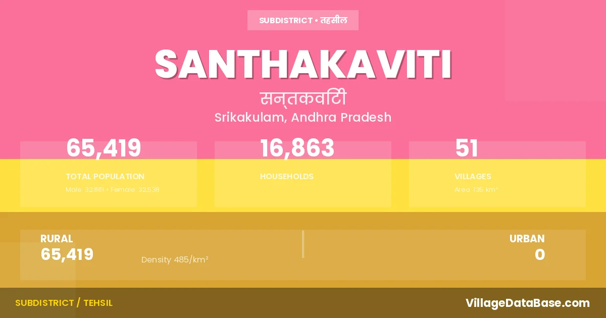
State → Andhra Pradesh
Santhakaviti is a town and Mandal in the Srikakulam district of the Andhra Pradesh. In India, a Mandal is a subdivision of a district responsible for the administration and revenue collection of a specific area within the district. Mandals play a crucial role in the local governance structure, contributing significantly to the development and administration of their communities.
According to the 2011 census The total area of Santhakaviti Mandal is 135 km², with a population of 65419 people. The population density is 485 inhabitants per square kilometre, and there are approximately 16863 houses in the sub district.
Santhakaviti Mandal comprises about 51 villages. Below is a list of these villages along with information about their respective gram panchayats and the nearest town:
| # | Village Name | Gram Panchayat | Nearest Town |
|---|---|---|---|
| 1 | Akkarapalle | Kakarapalli | Rajam (20 km) |
| 2 | Appalaagraharam | A P Agraharam | Rajam (24 km) |
| 3 | Billani | Billlani | Rajam (6 km) |
| 4 | Bodduru | Bodduru | Rajam (3 km) |
| 5 | Chennaiahpeta | Chinnayyapeta | Rajam (18 km) |
| 6 | Chintalapeta | Ramarayapuram | Rajam (21 km) |
| 7 | Chittaripuram | Chitaripuram | Rajam (38 km) |
| 8 | Garanaidupeta | Chitaripuram | Rajam (38 km) |
| 9 | Garikipadu | Garikipadu | Rajam (14 km) |
| 10 | Geddavalasa Narasimha Puram | G N Puram | Srikakulam (15 km) |
| 11 | Gollavalasa | Gollavalasa | Rajam (23 km) |
| 12 | Govindapuram | Govindhapuram | Rajam (21 km) |
| 13 | Gullaseetharama Puram | Gollaseetharampuram | Rajam (6 km) |
| 14 | Honjaram | Honjaram | Rajam (31 km) |
| 15 | Janakipuram | A P Agraharam | Rajam (24 km) |
| 16 | Javam | Javam | Rajam (24 km) |
| 17 | Kakarapalle | Kakarapalli | Rajam (18 km) |
| 18 | Kavali | Kavili | Rajam (36 km) |
| 19 | Kondagudem | Kondagudam | Rajam (22 km) |
| 20 | Kothuru Ramachandrapuram | K Ranachandhrapuram | Rajam (24 km) |
| 21 | Krishnamvalasa | Krishnamvalasa | Rajam (23 km) |
| 22 | Krishnasastrula Peta | Garikipadu | Rajam (15 km) |
| 23 | Lingapuram | Mamidipalli | Rajam (6 km) |
| 24 | Maddururamayyaagraharam | Gollavalasa | Rajam (23 km) |
| 25 | Madhavarayapu Ra Mayya Agraharam | Gollavalasa | Rajam (23 km) |
| 26 | Madhavarayapuram | Kondagudam | Rajam (24 km) |
| 27 | Mamidipalle | Mamidipalli | Rajam (14 km) |
| 28 | Mandarada | Mandarada | Rajam (18 km) |
| 29 | Mandavakuriti | Mandakurti | Rajam (10 km) |
| 30 | Manthina | Mantina | Rajam (26 km) |
| 31 | Medamarthi | Tamaram | Rajam (30 km) |
| 32 | Mirthivalasa | Mirthivalasa | Rajam (24 km) |
| 33 | Modugulapeta | Modugulapeta | Rajam (20 km) |
| 34 | Mokshaseetharamapuram | Pullita | Rajam (14 km) |
| 35 | Mukundapuram | Modugulapeta | Rajam (20 km) |
| 36 | Narayanarajupuram | Govindhapuram | Rajam (22 km) |
| 37 | Panasapeta | G N Puram | Srikakulam (15 km) |
| 38 | Podali | Chitaripuram | Rajam (36 km) |
| 39 | Pullita | Pullita | Rajam (14 km) |
| 40 | Ramarayapuram | Ramarayapuram | Rajam (22 km) |
| 41 | Sankaruni Agraharam | Gollavalasa | Rajam (22 km) |
| 42 | Santhakaviti | Santhakaviti | Rajam (16 km) |
| 43 | Seshadripuram | A P Agraharam | Rajam (24 km) |
| 44 | Shalipeta | Ramarayapuram | Rajam (22 km) |
| 45 | Siripuram | Siripuramm | Rajam (22 km) |
| 46 | Suravaram | Suravaram | Rajam (16 km) |
| 47 | Talada | Talada | Rajam (10 km) |
| 48 | Thalatampara | Talatampara | Rajam (6 km) |
| 49 | Thamaram | Tamaram | Rajam (29 km) |
| 50 | Valtair | Waltair | Rajam (36 km) |
| 51 | Vasudevapatnam | Vasudavapatnam | Rajam (26 km) |
The population is distributed between urban and rural areas as follows:
| Particulars | Rural | Urban | Total |
|---|---|---|---|
| Total Population | 65419 | 0 | 65419 |
| Male Population | 32881 | 0 | 32881 |
| Female Population | 32538 | 0 | 32538 | Population Density | 485 / km² | 485 / km² |
The distribution of households in the Santhakaviti is:
| Rural Households | Urban Households | Total Households |
|---|---|---|
| 16863 | 0 | 16863 |
Q: What is Santhakaviti?
A: Santhakaviti is a town and in the Srikakulam district of the Andhra Pradesh.
Q: What is the total area of Santhakaviti Mandal?
A: The total area of Santhakaviti Mandal is 135 km².
Q: What is the population of Santhakaviti Mandal according to the 2011 census?
A: According to the 2011 census, the population of Santhakaviti Mandal is 65419.
Q: What is the population density of Santhakaviti Mandal?
A: The population density of Santhakaviti Mandal is 485 inhabitants per square kilometre.
Q: How many houses are there in Santhakaviti Mandal?
A: There are approximately 16863 houses in Santhakaviti Mandal.
Q: How many villages are there in Santhakaviti Mandal?
A: There are about 51 villages in Santhakaviti Mandal.
Q: Which is the largest village by population in Santhakaviti Mandal?
A: The largest village by population in Santhakaviti Mandal is Siripuram, with 5206 people.
Q: Which is the smallest village by population in Santhakaviti Mandal?
A: The smallest village by population in Santhakaviti Mandal is Mokshaseetharamapuram, with 0 people.
Q: Which is the largest village by area in Santhakaviti Mandal?
A: The largest village by area in Santhakaviti Mandal is Mandavakuriti, with 1522 km².
Q: Which is the smallest village by area in Santhakaviti Mandal?
A: The smallest village by area in Santhakaviti Mandal is Madhavarayapu Ra Mayya Agraharam, with 26 km².
Q: What is the population distribution between urban and rural areas in Santhakaviti Mandal?
A: The population distribution in Santhakaviti Mandal is entirely rural, with a total rural population of 65419.
Q: What is the male population of Santhakaviti Mandal?
A: The male population of Santhakaviti Mandal is 32881.
Q: What is the female population of Santhakaviti Mandal?
A: The female population of Santhakaviti Mandal is 32538.
Q: How is the household distribution in Santhakaviti Mandal?
A: The household distribution in Santhakaviti Mandal is entirely rural, with a total of 16863 households.
Q: How many villages in Santhakaviti Mandal have a population of less than 100?
A: There are 1 villages in Santhakaviti Mandal with a population of less than 100.
Q: How many villages in Santhakaviti Mandal have a population between 100 and 499?
A: There are 10 villages in Santhakaviti Mandal with a population between 100 and 499.
Q: How many villages in Santhakaviti Mandal have a population between 500 and 999?
A: There are 15 villages in Santhakaviti Mandal with a population between 500 and 999.
Q: How many villages in Santhakaviti Mandal have a population between 1000 and 1999?
A: There are 16 villages in Santhakaviti Mandal with a population between 1000 and 1999.
Q: How many villages in Santhakaviti Mandal have a population between 2000 and 2999?
A: There is 6 village in Santhakaviti Mandal with a population between 2000 and 2999.
Q: How many villages in Santhakaviti Mandal have a population between 3000 and 3999?
A: There is 1 village in Santhakaviti Mandal with a population between 3000 and 3999.
Q: How many villages in Santhakaviti Mandal have a population between 4000 and 4999?
A: There is 1 village in Santhakaviti Mandal with a population between 4000 and 4999.
Q: How many villages in Santhakaviti Mandal have a population of 5000 and above?
A: There is 1 village in Santhakaviti Mandal with a population of 5000 and above.
| Total Population | Villages in Sub District Of Santhakaviti |
|---|---|
| Less than 100 | 1 |
| 100-499 | 10 |
| 500-999 | 15 |
| 1000-1999 | 16 |
| 2000-2999 | 6 |
| 3000-3999 | 1 |
| 4000-4999 | 1 |
| 5000 And Above | 1 |