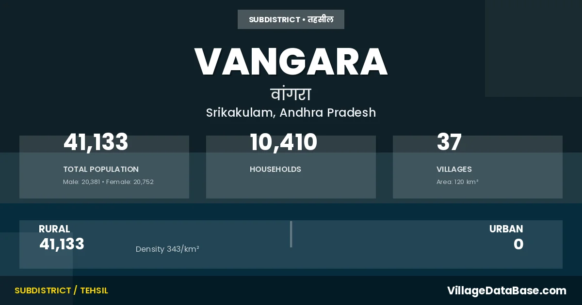
Vangara: A Town and Mandal in Srikakulam district
District → Srikakulam
State → Andhra Pradesh
Vangara is a town and Mandal in the Srikakulam district of the Andhra Pradesh. In India, a Mandal is a subdivision of a district responsible for the administration and revenue collection of a specific area within the district. Mandals play a crucial role in the local governance structure, contributing significantly to the development and administration of their communities.
According to the 2011 census The total area of Vangara Mandal is 120 km², with a population of 41133 people. The population density is 343 inhabitants per square kilometre, and there are approximately 10410 houses in the sub district.
Vangara Mandal comprises about 37 villages. Below is a list of these villages along with information about their respective gram panchayats and the nearest town:
| # | Village Name | Gram Panchayat | Nearest Town |
|---|---|---|---|
| 1 | Arasada | Arasada | Rajam (20 km) |
| 2 | Bangaruvalasa | Kopparavalasa | Rajam (32 km) |
| 3 | Bhagempeta | Bhagempeta | Rajam (26 km) |
| 4 | Chandrampeta | Konangipadu | Rajam (40 km) |
| 5 | Devakivada | Devakivada | Rajam (30 km) |
| 6 | Geethanapalle | Geetanapalli | Rajam (35 km) |
| 7 | Gudivada Agraharam | Rajam (39 km) | |
| 8 | Iruvada | Konangipadu | Rajam (32 km) |
| 9 | J K Gumada | V V R Peta | Parvathipuram (28 km) |
| 10 | Jagannadhavalasa | Madduvalasa | Rajam (25 km) |
| 11 | K Ch Palle | K Ch Palli | Rajam (40 km) |
| 12 | Kinjangi | Kinjangi | Rajam (32 km) |
| 13 | Konangipadu | Konangipadu | Rajam (46 km) |
| 14 | Koppara | Kopara | Rajam (35 km) |
| 15 | Kopparavalasa | Kopparavalasa | Rajam (33 km) |
| 16 | Kottisa | Kottisa | Rajam (36 km) |
| 17 | Laxmipeta | Laxmipeta | Rajam (36 km) |
| 18 | M S Puram | M S R Puram | Rajam (25 km) |
| 19 | Maddivalasa | Maddivalasa | Rajam (32 km) |
| 20 | Madduvalasa | Madduvalasa | Rajam (20 km) |
| 21 | Maruvada | Maruvada | Rajam (32 km) |
| 22 | Mugguru | Magguru | Rajam (25 km) |
| 23 | Narendrapuram | Sriharipuram | Rajam (36 km) |
| 24 | Neelayyavalasa | Neelayyavalasa | Rajam (26 km) |
| 25 | Patuvardhanam | Patuvardhanam | Rajam (20 km) |
| 26 | Rajulagumada | Rajulagumada | Rajam (45 km) |
| 27 | Rushingi | Rushingi | Rajam (28 km) |
| 28 | Sangam | Sangam | Rajam (26 km) |
| 29 | Seethadevipuram | Maruvada | Rajam (27 km) |
| 30 | Sivvam | Sivvam | Rajam (28 km) |
| 31 | Sreeharipuram | Sriharipuram | Rajam (36 km) |
| 32 | T D Krishnaraya Puram | Rushingi | Rajam (28 km) |
| 33 | Talagam | Talagam | Rajam (31 km) |
| 34 | U Venkatapathi Raju Peta | V V R Peta | Parvathipuram (28 km) |
| 35 | V P R Peta | Kinjangi | Rajam (32 km) |
| 36 | Vangara | Vangara | Rajam (28 km) |
| 37 | Voni Agraharam | Voni Agraharam | Rajam (24 km) |
The population is distributed between urban and rural areas as follows:
| Particulars | Rural | Urban | Total |
|---|---|---|---|
| Total Population | 41133 | 0 | 41133 |
| Male Population | 20381 | 0 | 20381 |
| Female Population | 20752 | 0 | 20752 | Population Density | 343 / km² | 343 / km² |
The distribution of households in the Vangara is:
| Rural Households | Urban Households | Total Households |
|---|---|---|
| 10410 | 0 | 10410 |
Q: What is Vangara?
A: Vangara is a town and in the Srikakulam district of the Andhra Pradesh.
Q: What is the total area of Vangara Mandal?
A: The total area of Vangara Mandal is 120 km².
Q: What is the population of Vangara Mandal according to the 2011 census?
A: According to the 2011 census, the population of Vangara Mandal is 41133.
Q: What is the population density of Vangara Mandal?
A: The population density of Vangara Mandal is 343 inhabitants per square kilometre.
Q: How many houses are there in Vangara Mandal?
A: There are approximately 10410 houses in Vangara Mandal.
Q: How many villages are there in Vangara Mandal?
A: There are about 37 villages in Vangara Mandal.
Q: Which is the largest village by population in Vangara Mandal?
A: The largest village by population in Vangara Mandal is Koppara, with 2968 people.
Q: Which is the smallest village by population in Vangara Mandal?
A: The smallest village by population in Vangara Mandal is Gudivada Agraharam, with 0 people.
Q: Which is the largest village by area in Vangara Mandal?
A: The largest village by area in Vangara Mandal is Arasada, with 730 km².
Q: Which is the smallest village by area in Vangara Mandal?
A: The smallest village by area in Vangara Mandal is Seethadevipuram, with 72 km².
Q: What is the population distribution between urban and rural areas in Vangara Mandal?
A: The population distribution in Vangara Mandal is entirely rural, with a total rural population of 41133.
Q: What is the male population of Vangara Mandal?
A: The male population of Vangara Mandal is 20381.
Q: What is the female population of Vangara Mandal?
A: The female population of Vangara Mandal is 20752.
Q: How is the household distribution in Vangara Mandal?
A: The household distribution in Vangara Mandal is entirely rural, with a total of 10410 households.
Q: How many villages in Vangara Mandal have a population of less than 100?
A: There are 6 villages in Vangara Mandal with a population of less than 100.
Q: How many villages in Vangara Mandal have a population between 100 and 499?
A: There are 2 villages in Vangara Mandal with a population between 100 and 499.
Q: How many villages in Vangara Mandal have a population between 500 and 999?
A: There are 7 villages in Vangara Mandal with a population between 500 and 999.
Q: How many villages in Vangara Mandal have a population between 1000 and 1999?
A: There are 18 villages in Vangara Mandal with a population between 1000 and 1999.
Q: How many villages in Vangara Mandal have a population between 2000 and 2999?
A: There is 4 village in Vangara Mandal with a population between 2000 and 2999.
| Total Population | Villages in Sub District Of Vangara |
|---|---|
| Less than 100 | 6 |
| 100-499 | 2 |
| 500-999 | 7 |
| 1000-1999 | 18 |
| 2000-2999 | 4 |