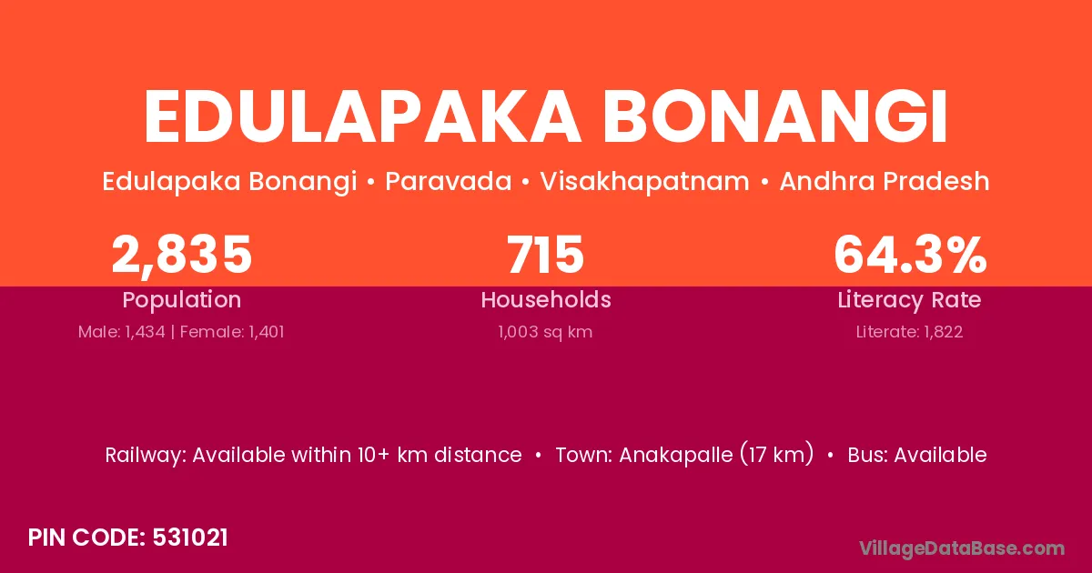
Edulapaka Bonangi village is located in the Paravada Mandal of the Visakhapatnam district in Andhra Pradesh .
Block / Mandal → Paravada
District → Visakhapatnam
State → Andhra Pradesh
According to Census 2011 information, the village code of Edulapaka Bonangi village is 531021.
Edulapaka Bonangi village has a total population of 2,835 people, of which 1,434 are males and 1,401 are females.
The literacy rate of Edulapaka Bonangi village is 64.27%. Male literacy stands at 72.87% and female literacy at 55.46%.
There are approximately 715 households in Edulapaka Bonangi village.
Anakapalle (17 km) is the nearest town to Edulapaka Bonangi village for major economic activities and is located approximately 17 km away.
The population of Edulapaka Bonangi village is distributed between literate and illiterate residents as follows:
| Particulars | Male | Female | Total |
|---|---|---|---|
| Literate | 1,045 | 777 | 1,822 |
| Illiterate | 389 | 624 | 1,013 |
| Total | 1,434 | 1,401 | 2,835 |
Source: Census 2011
| Village | District |
|---|---|
| Bharinikam | Visakhapatnam |
| Jagannadhapuram Agraharam | East Godavari |
| Jagannadhapuram Agraharam | Visakhapatnam |
| Lemarthi Agraharam | Visakhapatnam |
| Paravada | Visakhapatnam |
| Paravada | Porbandar |
| Payakarao Bonangi | Visakhapatnam |
| Pentaseema Bonangi | Visakhapatnam |
| Pinamadaka | Visakhapatnam |
| Ponnuruagraharam | Visakhapatnam |
| Ravada | Srikakulam |
| Ravada | Visakhapatnam |
| Ravada | Vizianagaram |
| Ravada | Vizianagaram |
| Swayambuvaram | Visakhapatnam |
| Thanam | Visakhapatnam |
No reviews yet. Be the first to review this village!
Available within 10+ km distance
Available within village
Available within <5 km distance