Srungavarapukota: A Town and Mandal in Vizianagaram district
District → Vizianagaram
State → Andhra Pradesh
Srungavarapukota is a town and Mandal in the Vizianagaram district of the Andhra Pradesh. In India, a Mandal is a subdivision of a district responsible for the administration and revenue collection of a specific area within the district. Mandals play a crucial role in the local governance structure, contributing significantly to the development and administration of their communities.
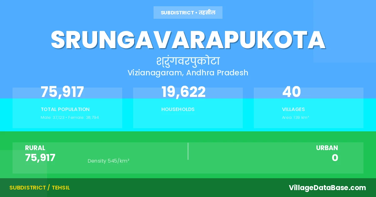
According to the 2011 census The total area of Srungavarapukota Mandal is 139 km², with a population of 75917 people. The population density is 545 inhabitants per square kilometre, and there are approximately 19622 houses in the sub district.
Srungavarapukota Mandal comprises about 40 villages. Below is a list of these villages along with information about their respective gram panchayats and the nearest town:
| # | Village Name | Gram Panchayat | Nearest Town |
|---|---|---|---|
| 1 | Alugubilli | Alugubilli | Vizianagaram (35 km) |
| 2 | Balakrishna Rajapuram | Sivaramarajupeta | Vizianagaram (38 km) |
| 3 | Chamalapalle | Chamalapalli | Vizianagaram (30 km) |
| 4 | Cheedipalem | Musidipalli | Vizianagaram (30 km) |
| 5 | Chinakhandepalle | Musidipalli | Vizianagaram (30 km) |
| 6 | Dampuram | Venkataramanapeta | Vizianagaram (38 km) |
| 7 | Daraparthi | Daraparthi | Vizianagaram (45 km) |
| 8 | Dharmavaram | Dharmavaram | Vizianagaram (28 km) |
| 9 | Gopalapalle | Gopalapalli | Vizianagaram (32 km) |
| 10 | Gunapadu | Daraparthi | Vizianagaram (48 km) |
| 11 | Jirayathi Kumaram | Kiltampalem | Vizianagaram (30 km) |
| 12 | Jirayathi Mukundapuram | Kiltampalem | Vizianagaram (30 km) |
| 13 | Kapusompuram | Mulaboddavara | Vizianagaram (30 km) |
| 14 | Kasipathi Rajapuram | Venkataramanapeta | Vizianagaram (40 km) |
| 15 | Kiltampalem | Kiltampalem | Vizianagaram (30 km) |
| 16 | Kondamallipudi | Venkataramanapeta | Vizianagaram (41 km) |
| 17 | Kothakota | Chamalapalli | Vizianagaram (20 km) |
| 18 | Kothavooru | Kothavuru | Vizianagaram (38 km) |
| 19 | Kottam | Kottam | Vizianagaram (30 km) |
| 20 | Krishnamahanti Puram | Kiltampalem | Vizianagaram (30 km) |
| 21 | Krishnapuram | Krishnapuram | Vizianagaram (35 km) |
| 22 | Kuridi | Daraparthi | Vizianagaram (50 km) |
| 23 | Mallipudi | Venkataramanapeta | Vizianagaram (38 km) |
| 24 | Mamidipalle | Mamidipalli | Vizianagaram (25 km) |
| 25 | Marupalle | Mulaboddavara | Vizianagaram (30 km) |
| 26 | Moolaboddavara | Mulaboddavara | Vizianagaram (30 km) |
| 27 | Mushidipalle | Musidipalli | Vizianagaram (24 km) |
| 28 | Pedakhandepalle | Pedakanepalli | Vizianagaram (35 km) |
| 29 | Pothanapalle | Pothanapalli | Vizianagaram (32 km) |
| 30 | S Kotatalari | S Kota Talari | Vizianagaram (30 km) |
| 31 | Santagavarampeta | S G Peta | Vizianagaram (30 km) |
| 32 | Srungavarapukota | Srungavarapukota | Vizianagaram (35 km) |
| 33 | Tennuboddavara | Mulaboddavara | Vizianagaram (30 km) |
| 34 | Thimidi | Thimidi | Vizianagaram (39 km) |
| 35 | Usiri | S Kota Talari | Vizianagaram (32 km) |
| 36 | Vasi | Vasi | Vizianagaram (41 km) |
| 37 | Veeranarayanam | Veeranarayanam | Vizianagaram (45 km) |
| 38 | Vemulapalle | Vemulapalli | Vizianagaram (28 km) |
| 39 | Vinayakapalle | Vinayakapali | Vizianagaram (30 km) |
| 40 | Viswanadhapuram | Musidipalli | Vizianagaram (30 km) |
The population is distributed between urban and rural areas as follows:
| Particulars | Rural | Urban | Total |
|---|---|---|---|
| Total Population | 75917 | 0 | 75917 |
| Male Population | 37123 | 0 | 37123 |
| Female Population | 38794 | 0 | 38794 | Population Density | 545 / km² | 545 / km² |
The distribution of households in the Srungavarapukota is:
| Rural Households | Urban Households | Total Households |
|---|---|---|
| 19622 | 0 | 19622 |
Q: What is Srungavarapukota?
A: Srungavarapukota is a town and in the Vizianagaram district of the Andhra Pradesh.
Q: What is the total area of Srungavarapukota Mandal?
A: The total area of Srungavarapukota Mandal is 139 km².
Q: What is the population of Srungavarapukota Mandal according to the 2011 census?
A: According to the 2011 census, the population of Srungavarapukota Mandal is 75917.
Q: What is the population density of Srungavarapukota Mandal?
A: The population density of Srungavarapukota Mandal is 545 inhabitants per square kilometre.
Q: How many houses are there in Srungavarapukota Mandal?
A: There are approximately 19622 houses in Srungavarapukota Mandal.
Q: How many villages are there in Srungavarapukota Mandal?
A: There are about 40 villages in Srungavarapukota Mandal.
Q: Which is the largest village by population in Srungavarapukota Mandal?
A: The largest village by population in Srungavarapukota Mandal is Srungavarapukota, with 28304 people.
Q: Which is the smallest village by population in Srungavarapukota Mandal?
A: The smallest village by population in Srungavarapukota Mandal is Jirayathi Mukundapuram, with 0 people.
Q: Which is the largest village by area in Srungavarapukota Mandal?
A: The largest village by area in Srungavarapukota Mandal is Moolaboddavara, with 2081 km².
Q: Which is the smallest village by area in Srungavarapukota Mandal?
A: The smallest village by area in Srungavarapukota Mandal is Gunapadu, with 13 km².
Q: What is the population distribution between urban and rural areas in Srungavarapukota Mandal?
A: The population distribution in Srungavarapukota Mandal is entirely rural, with a total rural population of 75917.
Q: What is the male population of Srungavarapukota Mandal?
A: The male population of Srungavarapukota Mandal is 37123.
Q: What is the female population of Srungavarapukota Mandal?
A: The female population of Srungavarapukota Mandal is 38794.
Q: How is the household distribution in Srungavarapukota Mandal?
A: The household distribution in Srungavarapukota Mandal is entirely rural, with a total of 19622 households.
Q: How many villages in Srungavarapukota Mandal have a population of less than 100?
A: There are 5 villages in Srungavarapukota Mandal with a population of less than 100.
Q: How many villages in Srungavarapukota Mandal have a population between 100 and 499?
A: There are 9 villages in Srungavarapukota Mandal with a population between 100 and 499.
Q: How many villages in Srungavarapukota Mandal have a population between 500 and 999?
A: There are 6 villages in Srungavarapukota Mandal with a population between 500 and 999.
Q: How many villages in Srungavarapukota Mandal have a population between 1000 and 1999?
A: There are 11 villages in Srungavarapukota Mandal with a population between 1000 and 1999.
Q: How many villages in Srungavarapukota Mandal have a population between 2000 and 2999?
A: There is 5 village in Srungavarapukota Mandal with a population between 2000 and 2999.
Q: How many villages in Srungavarapukota Mandal have a population between 3000 and 3999?
A: There is 1 village in Srungavarapukota Mandal with a population between 3000 and 3999.
Q: How many villages in Srungavarapukota Mandal have a population between 4000 and 4999?
A: There is 2 village in Srungavarapukota Mandal with a population between 4000 and 4999.
Q: How many villages in Srungavarapukota Mandal have a population of 5000 and above?
A: There is 1 village in Srungavarapukota Mandal with a population of 5000 and above.
| Total Population | Villages in Sub District Of Srungavarapukota |
|---|---|
| Less than 100 | 5 |
| 100-499 | 9 |
| 500-999 | 6 |
| 1000-1999 | 11 |
| 2000-2999 | 5 |
| 3000-3999 | 1 |
| 4000-4999 | 2 |
| 5000 And Above | 1 |