Therlam: A Town and Mandal in Vizianagaram district
District → Vizianagaram
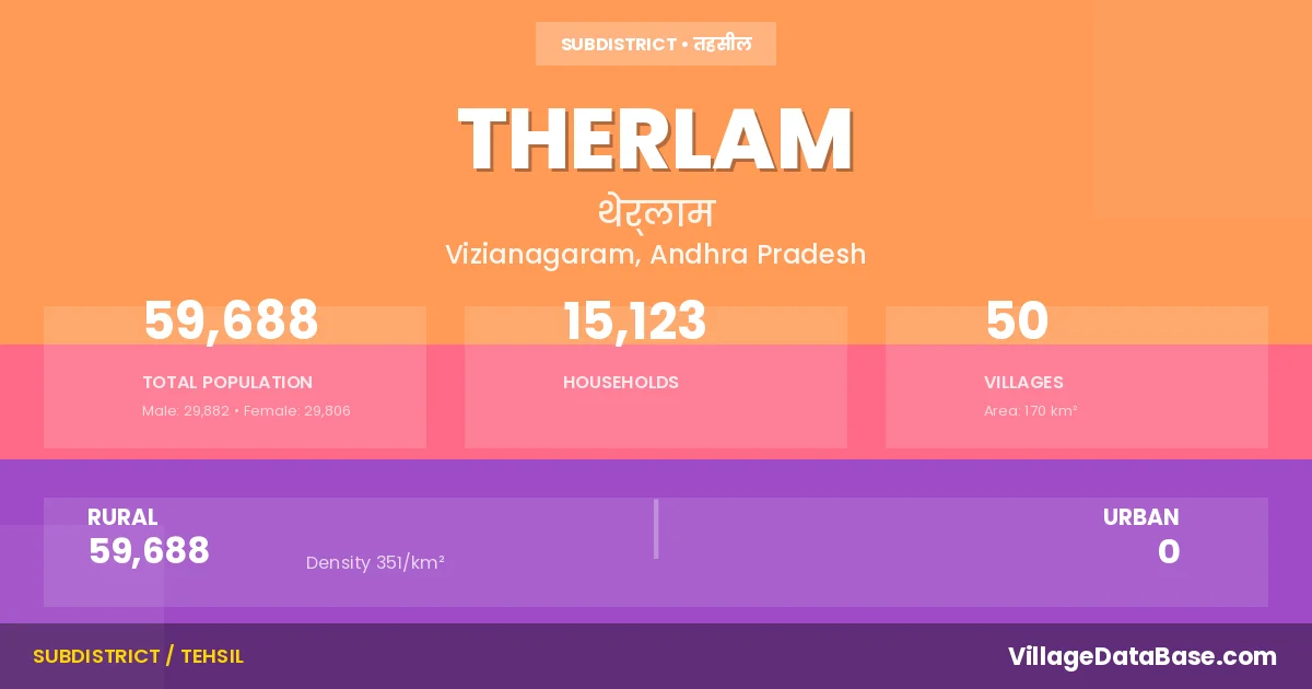
State → Andhra Pradesh
Therlam is a town and Mandal in the Vizianagaram district of the Andhra Pradesh. In India, a Mandal is a subdivision of a district responsible for the administration and revenue collection of a specific area within the district. Mandals play a crucial role in the local governance structure, contributing significantly to the development and administration of their communities.
According to the 2011 census The total area of Therlam Mandal is 170 km², with a population of 59688 people. The population density is 351 inhabitants per square kilometre, and there are approximately 15123 houses in the sub district.
Therlam Mandal comprises about 50 villages. Below is a list of these villages along with information about their respective gram panchayats and the nearest town:
| # | Village Name | Gram Panchayat | Nearest Town |
|---|---|---|---|
| 1 | Amity | Amity | Rajam (21 km) |
| 2 | Antlavara | Lingapuram | Bobbili (21 km) |
| 3 | Appalammapeta | Vijayarampuram | Rajam (28 km) |
| 4 | Arasabalaga | Arasabalaga | Rajam (10 km) |
| 5 | Burjavalasa Amity | N Burjavalsa | Rajam (22 km) |
| 6 | Chinapalavalasa | Punuvalasa | Rajam (13 km) |
| 7 | Chinnayyapeta | Chinnayapeta | Rajam (12 km) |
| 8 | Chukkavalasa | Chinnayapeta | Rajam (12 km) |
| 9 | Dommigani Gadabavalasa | D Gadabavalasa | Rajam (11 km) |
| 10 | Gangannapadu | Gangannapadu | Bobbili (21 km) |
| 11 | Goluguvalasa | Goluguvalsa | Rajam (29 km) |
| 12 | Jadavari Kothavalasa | Punuvalasa | Rajam (13 km) |
| 13 | Jannivalasa | Kunayavalasa | Bobbili (35 km) |
| 14 | Kagam | Kagam | Rajam (12 km) |
| 15 | Kavirayanivalasa | Kavirayanivalasa | Rajam (22 km) |
| 16 | Kollivalasa | Vijayarampuram | Rajam (25 km) |
| 17 | Koratam | Koratam | Bobbili (23 km) |
| 18 | Kunayavalasa | Kunayavalasa | Bobbili (30 km) |
| 19 | Kusumuru | Kusumuru | Bobbili (25 km) |
| 20 | Lingapuram | Lingapuram | Bobbili (20 km) |
| 21 | Locherla | Locherla | Bobbili (20 km) |
| 22 | Madhavarangarayapura Agraharam | Madhavarangarayapuram | Rajam (27 km) |
| 23 | Nandabalaga | Nandabalaga | Bobbili (16 km) |
| 24 | Nandigam | Nandigam | Bobbili (17 km) |
| 25 | Nemalam | Nemalam | Bobbili (42 km) |
| 26 | Panukuvalasa | Gapalavalasa | Rajam (13 km) |
| 27 | Pedapalavalasa | Punuvalasa | Rajam (13 km) |
| 28 | Perumali | Perumali | Rajam (10 km) |
| 29 | Pulleruvalasa | D Gadabavalasa | Bobbili (32 km) |
| 30 | Punuvalasa | Punuvalasa | Rajam (13 km) |
| 31 | Rajayyapeta | Rajayyapeta | Bobbili (19 km) |
| 32 | Ramachandrapuram Amity | Kavirayanivalasa | Rajam (22 km) |
| 33 | Ramachandrapuram Perumal | Velagavalasa | Bobbili (33 km) |
| 34 | Ramachandrapuram Velagavalasa | Arasabalaga | Bobbili (12 km) |
| 35 | Ramanna Agraharam | Rajayyapeta | Bobbili (17 km) |
| 36 | Rangappavalasa | Rangappavalasa | Bobbili (20 km) |
| 37 | Ravimanu Gadabavalasa | Nemalam | Bobbili (43 km) |
| 38 | Sathivada | Sathivada | Rajam (25 km) |
| 39 | Seetharampuram Amity | Kavirayanivalasa | Rajam (22 km) |
| 40 | Seetharampuram Koratam | Koratam | Bobbili (30 km) |
| 41 | Somidavalasa | Panukuvalasa | Rajam (12 km) |
| 42 | Sundarada | Sundarada | Rajam (22 km) |
| 43 | Tekkalivalasa | Perumali | Rajam (12 km) |
| 44 | Therlam | Rangappavalasa | Bobbili (23 km) |
| 45 | Uddavolu | Uddavolu | Rajam (25 km) |
| 46 | Velagavalasa | Velagavalasa | Bobbili (29 km) |
| 47 | Venkampeta Kummaripeta | Madhavarangarayapuram | Bobbili (24 km) |
| 48 | Venkatapuram | Chinnayapeta | Rajam (12 km) |
| 49 | Viziarampuram Buripeta | Vijayarampuram | Bobbili (27 km) |
| 50 | Viziarampuram Koratam | Koratam | Rajam (30 km) |
The population is distributed between urban and rural areas as follows:
| Particulars | Rural | Urban | Total |
|---|---|---|---|
| Total Population | 59688 | 0 | 59688 |
| Male Population | 29882 | 0 | 29882 |
| Female Population | 29806 | 0 | 29806 | Population Density | 351 / km² | 351 / km² |
The distribution of households in the Therlam is:
| Rural Households | Urban Households | Total Households |
|---|---|---|
| 15123 | 0 | 15123 |
Q: What is Therlam?
A: Therlam is a town and in the Vizianagaram district of the Andhra Pradesh.
Q: What is the total area of Therlam Mandal?
A: The total area of Therlam Mandal is 170 km².
Q: What is the population of Therlam Mandal according to the 2011 census?
A: According to the 2011 census, the population of Therlam Mandal is 59688.
Q: What is the population density of Therlam Mandal?
A: The population density of Therlam Mandal is 351 inhabitants per square kilometre.
Q: How many houses are there in Therlam Mandal?
A: There are approximately 15123 houses in Therlam Mandal.
Q: How many villages are there in Therlam Mandal?
A: There are about 50 villages in Therlam Mandal.
Q: Which is the largest village by population in Therlam Mandal?
A: The largest village by population in Therlam Mandal is Therlam, with 5793 people.
Q: Which is the smallest village by population in Therlam Mandal?
A: The smallest village by population in Therlam Mandal is Pulleruvalasa, with 0 people.
Q: Which is the largest village by area in Therlam Mandal?
A: The largest village by area in Therlam Mandal is Nandabalaga, with 1223 km².
Q: Which is the smallest village by area in Therlam Mandal?
A: The smallest village by area in Therlam Mandal is Ramachandrapuram Amity, with 42 km².
Q: What is the population distribution between urban and rural areas in Therlam Mandal?
A: The population distribution in Therlam Mandal is entirely rural, with a total rural population of 59688.
Q: What is the male population of Therlam Mandal?
A: The male population of Therlam Mandal is 29882.
Q: What is the female population of Therlam Mandal?
A: The female population of Therlam Mandal is 29806.
Q: How is the household distribution in Therlam Mandal?
A: The household distribution in Therlam Mandal is entirely rural, with a total of 15123 households.
Q: How many villages in Therlam Mandal have a population of less than 100?
A: There are 3 villages in Therlam Mandal with a population of less than 100.
Q: How many villages in Therlam Mandal have a population between 100 and 499?
A: There are 12 villages in Therlam Mandal with a population between 100 and 499.
Q: How many villages in Therlam Mandal have a population between 500 and 999?
A: There are 15 villages in Therlam Mandal with a population between 500 and 999.
Q: How many villages in Therlam Mandal have a population between 1000 and 1999?
A: There are 10 villages in Therlam Mandal with a population between 1000 and 1999.
Q: How many villages in Therlam Mandal have a population between 2000 and 2999?
A: There is 6 village in Therlam Mandal with a population between 2000 and 2999.
Q: How many villages in Therlam Mandal have a population between 3000 and 3999?
A: There is 3 village in Therlam Mandal with a population between 3000 and 3999.
Q: How many villages in Therlam Mandal have a population of 5000 and above?
A: There is 1 village in Therlam Mandal with a population of 5000 and above.
| Total Population | Villages in Sub District Of Therlam |
|---|---|
| Less than 100 | 3 |
| 100-499 | 12 |
| 500-999 | 15 |
| 1000-1999 | 10 |
| 2000-2999 | 6 |
| 3000-3999 | 3 |
| 5000 And Above | 1 |