Jairampur: A Town and Circle in Changlang district
District → Changlang
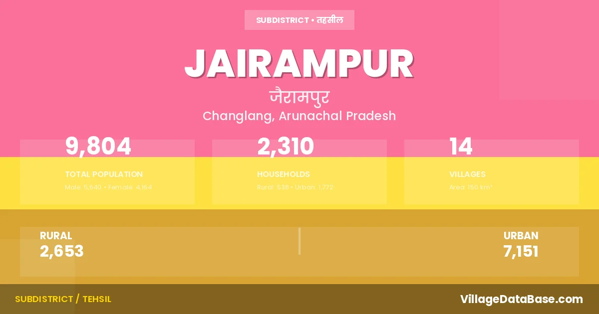
State → Arunachal Pradesh
Jairampur is a town and Circle in the Changlang district of the Arunachal Pradesh. In India, a Circle is a subdivision of a district responsible for the administration and revenue collection of a specific area within the district. Circles play a crucial role in the local governance structure, contributing significantly to the development and administration of their communities.
According to the 2011 census The total area of Jairampur Circle is 150 km², with a population of 9804 people. The population density is 65 inhabitants per square kilometre, and there are approximately 2310 houses in the sub district.
Jairampur Circle comprises about 14 villages. Below is a list of these villages along with information about their respective gram panchayats and the nearest town:
| # | Village Name | Gram Panchayat | Nearest Town |
|---|---|---|---|
| 1 | 3 K M Pwd Camp | Jairampur | |
| 2 | 8 K M Tea Garden | Jairampur | |
| 3 | Chamro | Jairampur | |
| 4 | Hetlong | Jairampur | |
| 5 | Honkap | Jairampur | |
| 6 | Khamdu | Jairampur | |
| 7 | Kovin | Jairampur | |
| 8 | Longman | Jairampur | |
| 9 | Longvi | Jairampur | |
| 10 | Namchik Pwd Camp | Jairampur | |
| 11 | New Khamdu | Jairampur | |
| 12 | Tengmo | Jairampur | |
| 13 | Tikhak Taipi | Jairampur | |
| 14 | Typong | Jairampur |
The population is distributed between urban and rural areas as follows:
| Particulars | Rural | Urban | Total |
|---|---|---|---|
| Total Population | 2653 | 7151 | 9804 |
| Male Population | 1420 | 4220 | 5640 |
| Female Population | 1233 | 2931 | 4164 | Population Density | 65 / km² |
The distribution of households in the Jairampur is:
| Rural Households | Urban Households | Total Households |
|---|---|---|
| 538 | 1772 | 2310 |
Q: What is Jairampur?
A: Jairampur is a town and in the Changlang district of the Arunachal Pradesh.
Q: What is the total area of Jairampur Circle?
A: The total area of Jairampur Circle is 150 km².
Q: What is the population of Jairampur Circle according to the 2011 census?
A: According to the 2011 census, the population of Jairampur Circle is 9804.
Q: What is the population density of Jairampur Circle?
A: The population density of Jairampur Circle is 65 inhabitants per square kilometre.
Q: How many houses are there in Jairampur Circle?
A: There are approximately 2310 houses in Jairampur Circle.
Q: How many villages are there in Jairampur Circle?
A: There are about 14 villages in Jairampur Circle.
Q: Which is the largest village by population in Jairampur Circle?
A: The largest village by population in Jairampur Circle is Chamro, with 580 people.
Q: Which is the smallest village by population in Jairampur Circle?
A: The smallest village by population in Jairampur Circle is 3 K M Pwd Camp, with 0 people.
Q: Which is the largest village by area in Jairampur Circle?
A: The largest village by area in Jairampur Circle is 3 K M Pwd Camp, with 0 km².
Q: Which is the smallest village by area in Jairampur Circle?
A: The smallest village by area in Jairampur Circle is 3 K M Pwd Camp, with 0 km².
Q: What is the male population of Jairampur Circle?
A: The male population of Jairampur Circle is 5640.
Q: What is the female population of Jairampur Circle?
A: The female population of Jairampur Circle is 4164.
Q: How many villages in Jairampur Circle have a population of less than 100?
A: There are 4 villages in Jairampur Circle with a population of less than 100.
Q: How many villages in Jairampur Circle have a population between 100 and 499?
A: There are 9 villages in Jairampur Circle with a population between 100 and 499.
Q: How many villages in Jairampur Circle have a population between 500 and 999?
A: There are 1 villages in Jairampur Circle with a population between 500 and 999.
| Total Population | Villages in Sub District Of Jairampur |
|---|---|
| Less than 100 | 4 |
| 100-499 | 9 |
| 500-999 | 1 |