Chayangtajo: A Town and Circle in East Kameng district
District → East Kameng
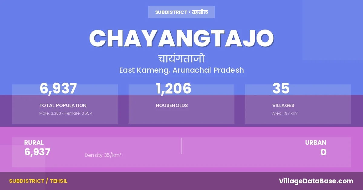
State → Arunachal Pradesh
Chayangtajo is a town and Circle in the East Kameng district of the Arunachal Pradesh. In India, a Circle is a subdivision of a district responsible for the administration and revenue collection of a specific area within the district. Circles play a crucial role in the local governance structure, contributing significantly to the development and administration of their communities.
According to the 2011 census The total area of Chayangtajo Circle is 197 km², with a population of 6937 people. The population density is 35 inhabitants per square kilometre, and there are approximately 1206 houses in the sub district.
Chayangtajo Circle comprises about 35 villages. Below is a list of these villages along with information about their respective gram panchayats and the nearest town:
| # | Village Name | Gram Panchayat | Nearest Town |
|---|---|---|---|
| 1 | Basu Camp | Domdila | Seppa (56 km) |
| 2 | Chankiu Yangfo | Seppa (94 km) | |
| 3 | Chayangtajo H Q | Seppa (81 km) | |
| 4 | Dache Sullung | Seppa (100 km) | |
| 5 | Dambua Tajo | Seppa (76 km) | |
| 6 | Domdila Tajo | Seppa (63 km) | |
| 7 | Doripu Bagang | Laching Bagang | Seppa (103 km) |
| 8 | Hara Yangfo | Seppa (105 km) | |
| 9 | Jattom Sullung | Sepopa (106 km) | |
| 10 | Jayang Bagang | Seppa (98 km) | |
| 11 | Kamke | Killo | Seppa (94 km) |
| 12 | Kapik Sullung | Seppa (90 km) | |
| 13 | Kesse Bagang | Jayang Bagang | Seppa (103 km) |
| 14 | Keyong | Seppa (93 km) | |
| 15 | Killo | Killo | Seppa (91 km) |
| 16 | Laching Bagang | Seppa (109 km) | |
| 17 | Langruk Tajo | Seppa (61 km) | |
| 18 | Mara Tassar Sullung | Seppa (107 km) | |
| 19 | Namchar Bagang | Namchar Bagang | Seppa (102 km) |
| 20 | Nampe Bagang | Seppa (54 km) | |
| 21 | Paje Tassar | Seppa (108 km) | |
| 22 | Rayak Sullung | Seppa (107 km) | |
| 23 | Rebe | Seppa (87 km) | |
| 24 | Saliwa Yangfo | Seppa (93 km) | |
| 25 | Sangchu Sullung | Seppa (86 km) | |
| 26 | Sangriwa | Seppa (86 km) | |
| 27 | Soshi Bagang | Seppa (100 km) | |
| 28 | Tagampu Sullung | Seppa (95 km) | |
| 29 | Tajo | Seppa (69 km) | |
| 30 | Tamak Sullung | Seppa (115 km) | |
| 31 | Tamsang Yangfo | Seppa (93 km) | |
| 32 | Tarawa Yangfo | Seppa (94 km) | |
| 33 | Tassar Sullung | Seppa (106 km) | |
| 34 | Wada Bagang | Seppa (88 km) | |
| 35 | Yangfo | Seppa (93 km) |
The population is distributed between urban and rural areas as follows:
| Particulars | Rural | Urban | Total |
|---|---|---|---|
| Total Population | 6937 | 0 | 6937 |
| Male Population | 3383 | 0 | 3383 |
| Female Population | 3554 | 0 | 3554 | Population Density | 35 / km² | 35 / km² |
The distribution of households in the Chayangtajo is:
| Rural Households | Urban Households | Total Households |
|---|---|---|
| 1206 | 0 | 1206 |
Q: What is Chayangtajo?
A: Chayangtajo is a town and in the East Kameng district of the Arunachal Pradesh.
Q: What is the total area of Chayangtajo Circle?
A: The total area of Chayangtajo Circle is 197 km².
Q: What is the population of Chayangtajo Circle according to the 2011 census?
A: According to the 2011 census, the population of Chayangtajo Circle is 6937.
Q: What is the population density of Chayangtajo Circle?
A: The population density of Chayangtajo Circle is 35 inhabitants per square kilometre.
Q: How many houses are there in Chayangtajo Circle?
A: There are approximately 1206 houses in Chayangtajo Circle.
Q: How many villages are there in Chayangtajo Circle?
A: There are about 35 villages in Chayangtajo Circle.
Q: Which is the largest village by population in Chayangtajo Circle?
A: The largest village by population in Chayangtajo Circle is Chayangtajo H Q, with 1329 people.
Q: Which is the smallest village by population in Chayangtajo Circle?
A: The smallest village by population in Chayangtajo Circle is Langruk Tajo, with 15 people.
Q: Which is the largest village by area in Chayangtajo Circle?
A: The largest village by area in Chayangtajo Circle is Basu Camp, with 0 km².
Q: Which is the smallest village by area in Chayangtajo Circle?
A: The smallest village by area in Chayangtajo Circle is Basu Camp, with 0 km².
Q: What is the population distribution between urban and rural areas in Chayangtajo Circle?
A: The population distribution in Chayangtajo Circle is entirely rural, with a total rural population of 6937.
Q: What is the male population of Chayangtajo Circle?
A: The male population of Chayangtajo Circle is 3383.
Q: What is the female population of Chayangtajo Circle?
A: The female population of Chayangtajo Circle is 3554.
Q: How is the household distribution in Chayangtajo Circle?
A: The household distribution in Chayangtajo Circle is entirely rural, with a total of 1206 households.
Q: How many villages in Chayangtajo Circle have a population of less than 100?
A: There are 13 villages in Chayangtajo Circle with a population of less than 100.
Q: How many villages in Chayangtajo Circle have a population between 100 and 499?
A: There are 19 villages in Chayangtajo Circle with a population between 100 and 499.
Q: How many villages in Chayangtajo Circle have a population between 500 and 999?
A: There are 2 villages in Chayangtajo Circle with a population between 500 and 999.
Q: How many villages in Chayangtajo Circle have a population between 1000 and 1999?
A: There are 1 villages in Chayangtajo Circle with a population between 1000 and 1999.
| Total Population | Villages in Sub District Of Chayangtajo |
|---|---|
| Less than 100 | 13 |
| 100-499 | 19 |
| 500-999 | 2 |
| 1000-1999 | 1 |