District → Kurung Kumey
State → Arunachal Pradesh
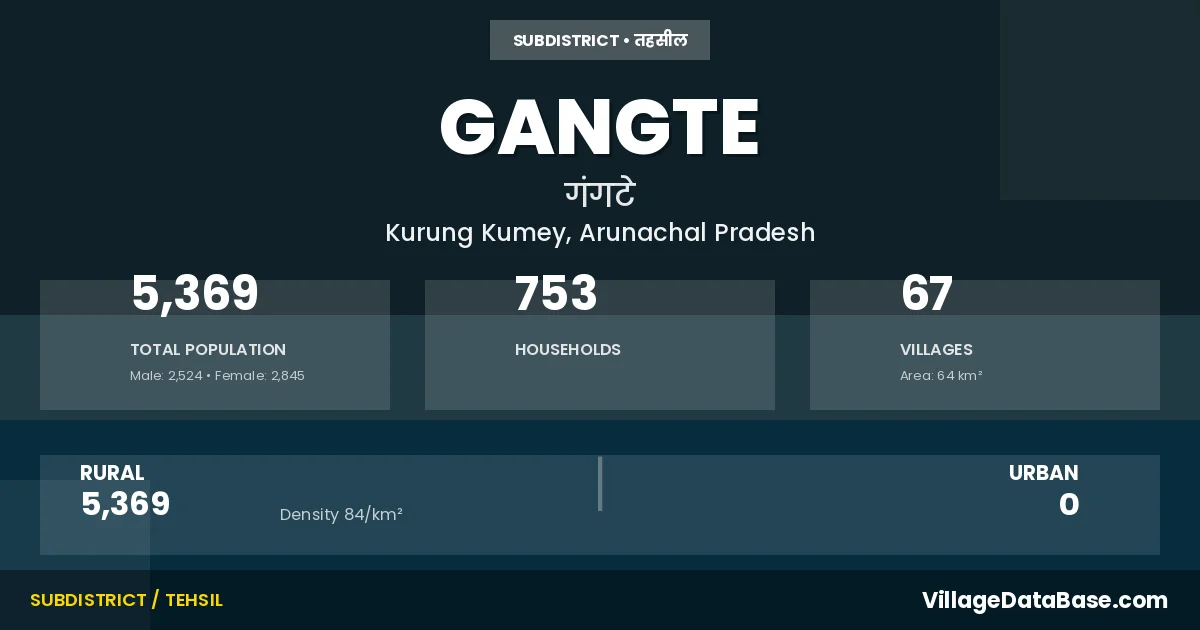
Gangte is a town and Circle in the Kurung Kumey district of the Arunachal Pradesh. In India, a Circle is a subdivision of a district responsible for the administration and revenue collection of a specific area within the district. Circles play a crucial role in the local governance structure, contributing significantly to the development and administration of their communities.
According to the 2011 census The total area of Gangte Circle is 64 km², with a population of 5369 people. The population density is 84 inhabitants per square kilometre, and there are approximately 753 houses in the sub district.
Gangte Circle comprises about 67 villages. Below is a list of these villages along with information about their respective gram panchayats and the nearest town:
| # | Village Name | Gram Panchayat | Nearest Town |
|---|---|---|---|
| 1 | Amprakpak | Koloriang (170 km) | |
| 2 | Ballo I | Gangte (25 km) | |
| 3 | Ballo Ii | Koloriang (180 km) | |
| 4 | Banga Kotho | Koloriang (180 km) | |
| 5 | Bindo | Gangte | |
| 6 | Boa | Gangte (30 km) | |
| 7 | Boa Ii | Gangte (14 km) | |
| 8 | Bomahapa | Koloriang (180 km) | |
| 9 | Boring | Koloriang (160 km) | |
| 10 | Bungkung | Koloriang (180 km) | |
| 11 | Chakbang | Koloriang (176 km) | |
| 12 | Dayam Hapa | Koloriang (200 km) | |
| 13 | Gad | Ganagte (25 km) | |
| 14 | Gai Ii | Kolorianf (175 km) | |
| 15 | Gai Iii | Gangte (25 km) | |
| 16 | Gai Iv | Gangte (23 km) | |
| 17 | Gangte | Koloriang (180 km) | |
| 18 | Gangte Ii | Koloriang (186 km) | |
| 19 | Genchi | Koloriang (180 km) | |
| 20 | Gongbing | Koloriang (175 km) | |
| 21 | Hidung Songo | Koloriang (150 km) | |
| 22 | Higio | Higio | Koloriang (170 km) |
| 23 | Higio Ii | Gangte (25 km) | |
| 24 | Huryung | Gangte (18 km) | |
| 25 | Kamrong Ii | Koloriang (180 km) | |
| 26 | Kamrung Iii | Koloriang (180 km) | |
| 27 | Korayer | Koloriang (180 km) | |
| 28 | Lapte | Koloriang (182 km) | |
| 29 | Lengdi I | Koloriang (180 km) | |
| 30 | Lomak Hapa | Koloriang (180 km) | |
| 31 | Lungchi | Koloriang (180 km) | |
| 32 | Malin | Gangte (15 km) | |
| 33 | Mebia | Ganhte (22 km) | |
| 34 | Mencha | Koloriang (180 km) | |
| 35 | Mugli | Koloriang (180 km) | |
| 36 | Pakung | Koloriang (180 km) | |
| 37 | Paring | Koloriang (200 km) | |
| 38 | Pha | Gangte (15 km) | |
| 39 | Phacha | Gangte (14 km) | |
| 40 | Phoi | Kolorianf (180 km) | |
| 41 | Pitak | Koloriang (200 km) | |
| 42 | Pokpu | Koloriang (200 km) | |
| 43 | Pukpe | Gangte (3 km) | |
| 44 | Rai | Koloriang (180 km) | |
| 45 | Rai Ii | Koloriang (170 km) | |
| 46 | Raibalo | Koloriang (105 km) | |
| 47 | Raibalo Ii | Gangte (30 km) | |
| 48 | Raibalo Iii | Gangte (25 km) | |
| 49 | Raiga | Koloriang (180 km) | |
| 50 | Raiga Ii | Koloriang (185 km) | |
| 51 | Sango | Gangte (14 km) | |
| 52 | Sango Ii | Gangte (14 km) | |
| 53 | Tabum | Gangte (25 km) | |
| 54 | Tabyer | Koloriang (180 km) | |
| 55 | Tagiaraha | Koloriang (150 km) | |
| 56 | Taliyer | Gangte (25 km) | |
| 57 | Tamak Poring | Gangte (2 km) | |
| 58 | Tarha | Koloriang (180 km) | |
| 59 | Tatung Koter | Koloriang (150 km) | |
| 60 | Taya Rimpa | Koloriang (170 km) | |
| 61 | Techipu | Gaangte (25 km) | |
| 62 | Techipu Koto | Koloriang (190 km) | |
| 63 | Tumhaming | Koloriang (180 km) | |
| 64 | Tungte | Gangte (25 km) | |
| 65 | Yangte | Gangte (36 km) | |
| 66 | Yangte Ii | Gangte (23 km) | |
| 67 | Yorte | Koloriang (180 km) |
The population is distributed between urban and rural areas as follows:
| Particulars | Rural | Urban | Total |
|---|---|---|---|
| Total Population | 5369 | 0 | 5369 |
| Male Population | 2524 | 0 | 2524 |
| Female Population | 2845 | 0 | 2845 | Population Density | 84 / km² | 84 / km² |
The distribution of households in the Gangte is:
| Rural Households | Urban Households | Total Households |
|---|---|---|
| 753 | 0 | 753 |
Q: What is Gangte?
A: Gangte is a town and in the Kurung Kumey district of the Arunachal Pradesh.
Q: What is the total area of Gangte Circle?
A: The total area of Gangte Circle is 64 km².
Q: What is the population of Gangte Circle according to the 2011 census?
A: According to the 2011 census, the population of Gangte Circle is 5369.
Q: What is the population density of Gangte Circle?
A: The population density of Gangte Circle is 84 inhabitants per square kilometre.
Q: How many houses are there in Gangte Circle?
A: There are approximately 753 houses in Gangte Circle.
Q: How many villages are there in Gangte Circle?
A: There are about 67 villages in Gangte Circle.
Q: Which is the largest village by population in Gangte Circle?
A: The largest village by population in Gangte Circle is Paring, with 270 people.
Q: Which is the smallest village by population in Gangte Circle?
A: The smallest village by population in Gangte Circle is Genchi, with 11 people.
Q: Which is the largest village by area in Gangte Circle?
A: The largest village by area in Gangte Circle is Amprakpak, with 0 km².
Q: Which is the smallest village by area in Gangte Circle?
A: The smallest village by area in Gangte Circle is Amprakpak, with 0 km².
Q: What is the population distribution between urban and rural areas in Gangte Circle?
A: The population distribution in Gangte Circle is entirely rural, with a total rural population of 5369.
Q: What is the male population of Gangte Circle?
A: The male population of Gangte Circle is 2524.
Q: What is the female population of Gangte Circle?
A: The female population of Gangte Circle is 2845.
Q: How is the household distribution in Gangte Circle?
A: The household distribution in Gangte Circle is entirely rural, with a total of 753 households.
Q: How many villages in Gangte Circle have a population of less than 100?
A: There are 47 villages in Gangte Circle with a population of less than 100.
Q: How many villages in Gangte Circle have a population between 100 and 499?
A: There are 20 villages in Gangte Circle with a population between 100 and 499.
| Total Population | Villages in Sub District Of Gangte |
|---|---|
| Less than 100 | 47 |
| 100-499 | 20 |