Koloriang: A Town and Circle in Kurung Kumey district
District → Kurung Kumey
State → Arunachal Pradesh
Koloriang is a town and Circle in the Kurung Kumey district of the Arunachal Pradesh. In India, a Circle is a subdivision of a district responsible for the administration and revenue collection of a specific area within the district. Circles play a crucial role in the local governance structure, contributing significantly to the development and administration of their communities.
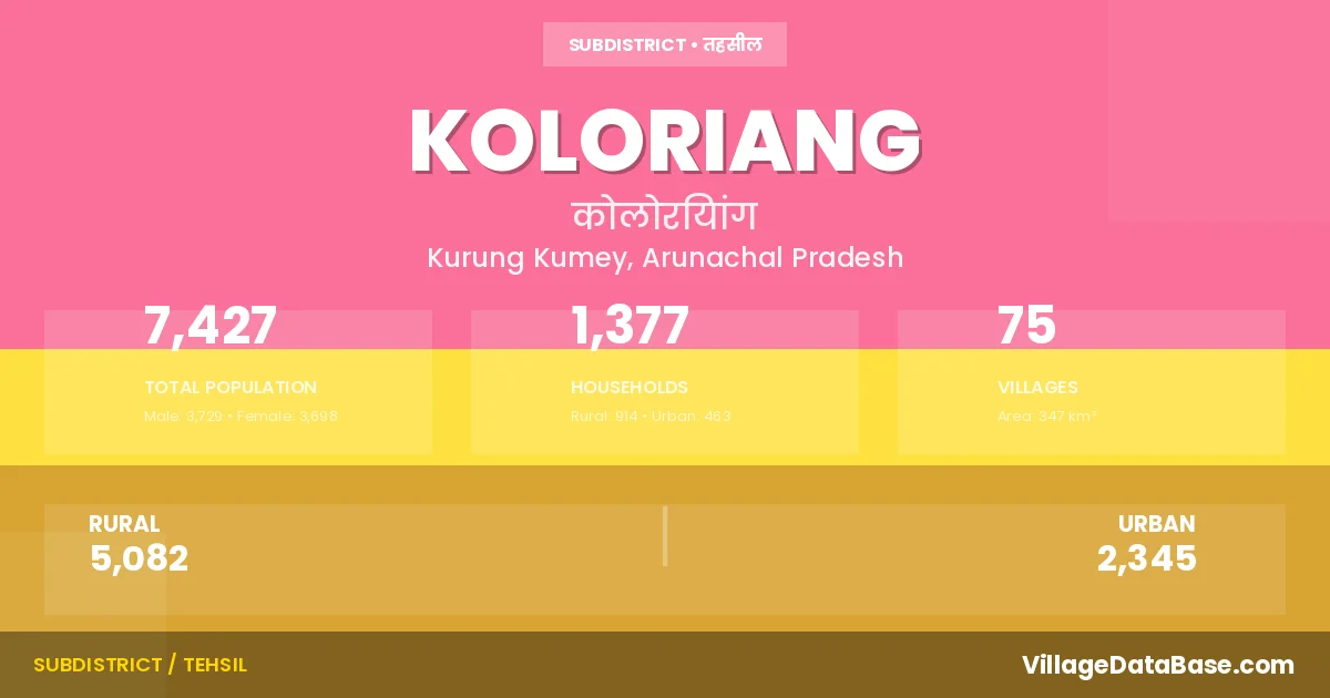
According to the 2011 census The total area of Koloriang Circle is 347 km², with a population of 7427 people. The population density is 21 inhabitants per square kilometre, and there are approximately 1377 houses in the sub district.
Koloriang Circle comprises about 75 villages. Below is a list of these villages along with information about their respective gram panchayats and the nearest town:
| # | Village Name | Gram Panchayat | Nearest Town |
|---|---|---|---|
| 1 | Ampongne | Koloriang | |
| 2 | Bridge Point | Koloriang | |
| 3 | Buhan | Koloriang | |
| 4 | Buyang | Koloriang | |
| 5 | Buyang Ii | Koloriang | |
| 6 | Chello | Koloriang | |
| 7 | Chimpu | Koloriang | |
| 8 | Chinkongne Village | Koloriang | |
| 9 | Chomi | Koloriang | |
| 10 | Chote | Koloriang | |
| 11 | Degging I | Koloriang | |
| 12 | Degging Ii | Koloriang | |
| 13 | Deyang | Koloriang | |
| 14 | Digging | Koloriang | |
| 15 | Dillang New | Koloriang | |
| 16 | Dome | Koloriang | |
| 17 | Fua | Koloriang | |
| 18 | Furek | Koloriang | |
| 19 | Harang | Koloriang | |
| 20 | Jeevandept | Koloriang | |
| 21 | Jiri | Koloriang | |
| 22 | Johat | Koloriang | |
| 23 | Kachanjane | Koloriang | |
| 24 | Kele | Koloriang | |
| 25 | Keya | Koloriang | |
| 26 | Kiodhriang | Koloriang | |
| 27 | Kokpu Nyoyer | Koloriang | |
| 28 | Kush | Koloriang | |
| 29 | Mange | Koloriang | |
| 30 | Manghe I | Koloriang | |
| 31 | Manghe Ii | Koloriang | |
| 32 | Mara | Koloriang | |
| 33 | Naji Bibok | Koloriang | |
| 34 | Nangram | Koloriang | |
| 35 | Nikja | Koloriang | |
| 36 | Nyobia | Koloriang | |
| 37 | Nyolo | Koloriang | |
| 38 | Pakba | Koloriang | |
| 39 | Pani | Koloriang | |
| 40 | Papin | Koloriang | |
| 41 | Papu | Koloriang | |
| 42 | Pari | Koloriang | |
| 43 | Pinging | Koloriang | |
| 44 | Puriok | Koloriang | |
| 45 | Radang | Koloriang | |
| 46 | Rakte | Koloriang | |
| 47 | Rambo | Koloriang | |
| 48 | Rare | Koloriang | |
| 49 | Ratell | Koloriang | |
| 50 | Relung | Koloriang | |
| 51 | Relung New Camp | Koloriang | |
| 52 | Rengchi | Koloriang | |
| 53 | Rite | Koloriang | |
| 54 | Sangchu | Koloriang | |
| 55 | Sangkun | Koloriang | |
| 56 | Sangsar | Koloriang | |
| 57 | Sarte Village | Koloriang | |
| 58 | Satum | Koloriang | |
| 59 | Sebi | Koloriang | |
| 60 | Sebiangriang | Koloriang | |
| 61 | Sollung Tapin | Koloriang | |
| 62 | Sulungyar | Koloriang | |
| 63 | Taba | Koloriang | |
| 64 | Tabuma | Koloriang | |
| 65 | Taipa | Koloriang | |
| 66 | Tamia | Koloriang | |
| 67 | Tapin | Koloriang | |
| 68 | Tapone | Koloriang | |
| 69 | Tate | Koloriang | |
| 70 | Tayeng | Koloriang | |
| 71 | Yapak Ii | Koloriang | |
| 72 | Yapha | Koloriang | |
| 73 | Yarkam | Koloriang | |
| 74 | Yarpu | Koloriang | |
| 75 | Yumlam | Koloriang |
The population is distributed between urban and rural areas as follows:
| Particulars | Rural | Urban | Total |
|---|---|---|---|
| Total Population | 5082 | 2345 | 7427 |
| Male Population | 2483 | 1246 | 3729 |
| Female Population | 2599 | 1099 | 3698 | Population Density | 21 / km² |
The distribution of households in the Koloriang is:
| Rural Households | Urban Households | Total Households |
|---|---|---|
| 914 | 463 | 1377 |
Q: What is Koloriang?
A: Koloriang is a town and in the Kurung Kumey district of the Arunachal Pradesh.
Q: What is the total area of Koloriang Circle?
A: The total area of Koloriang Circle is 347 km².
Q: What is the population of Koloriang Circle according to the 2011 census?
A: According to the 2011 census, the population of Koloriang Circle is 7427.
Q: What is the population density of Koloriang Circle?
A: The population density of Koloriang Circle is 21 inhabitants per square kilometre.
Q: How many houses are there in Koloriang Circle?
A: There are approximately 1377 houses in Koloriang Circle.
Q: How many villages are there in Koloriang Circle?
A: There are about 75 villages in Koloriang Circle.
Q: Which is the largest village by population in Koloriang Circle?
A: The largest village by population in Koloriang Circle is Nangram, with 350 people.
Q: Which is the smallest village by population in Koloriang Circle?
A: The smallest village by population in Koloriang Circle is Ampongne, with 0 people.
Q: Which is the largest village by area in Koloriang Circle?
A: The largest village by area in Koloriang Circle is Ampongne, with 0 km².
Q: Which is the smallest village by area in Koloriang Circle?
A: The smallest village by area in Koloriang Circle is Ampongne, with 0 km².
Q: What is the male population of Koloriang Circle?
A: The male population of Koloriang Circle is 3729.
Q: What is the female population of Koloriang Circle?
A: The female population of Koloriang Circle is 3698.
Q: How many villages in Koloriang Circle have a population of less than 100?
A: There are 60 villages in Koloriang Circle with a population of less than 100.
Q: How many villages in Koloriang Circle have a population between 100 and 499?
A: There are 15 villages in Koloriang Circle with a population between 100 and 499.
| Total Population | Villages in Sub District Of Koloriang |
|---|---|
| Less than 100 | 60 |
| 100-499 | 15 |