District → Lohit
State → Arunachal Pradesh
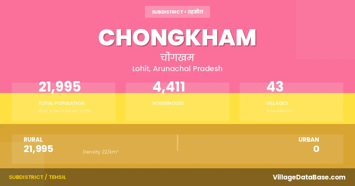
Chongkham is a town and Circle in the Lohit district of the Arunachal Pradesh. In India, a Circle is a subdivision of a district responsible for the administration and revenue collection of a specific area within the district. Circles play a crucial role in the local governance structure, contributing significantly to the development and administration of their communities.
According to the 2011 census The total area of Chongkham Circle is 996 km², with a population of 21995 people. The population density is 22 inhabitants per square kilometre, and there are approximately 4411 houses in the sub district.
Chongkham Circle comprises about 43 villages. Below is a list of these villages along with information about their respective gram panchayats and the nearest town:
| # | Village Name | Gram Panchayat | Nearest Town |
|---|---|---|---|
| 1 | Alubari | Alubari | Namsai (36 km) |
| 2 | Alubari Ghat | Namsai (37 km) | |
| 3 | Alubari Main Wood Area | Namsai (34 km) | |
| 4 | Chakma I | Namsai (35 km) | |
| 5 | Chakma Ii | Namsai (37 km) | |
| 6 | Chakma Iii | Namsai (38 km) | |
| 7 | Chongkham H Q | Chongkham Hq | Namsai (30 km) |
| 8 | Chowkham | Namsai (32 km) | |
| 9 | Chowkham I | Chongkham I | Chongkham |
| 10 | Chowkham Ii | Chongkham Ii | Namsai (31 km) |
| 11 | Chowkham Iii | Chongkham Iii | Namsai (31 km) |
| 12 | Chowkham Iv | Chongkham Iv | Namsai (30 km) |
| 13 | Chowkham Tengapani Area | Namsai (23 km) | |
| 14 | Embong | Namsai (67 km) | |
| 15 | Emphum | Emphum | Namsai (46 km) |
| 16 | Empong | Namsai (33 km) | |
| 17 | Guna Nagar I | Guna Nagar | Chongkham |
| 18 | Guna Nagar Ii | Guna Nagar | Namsai (33 km) |
| 19 | Injo | Namsai (115 km) | |
| 20 | Insa | Insa | Namsai (75 km) |
| 21 | Kherem | Kherem | Namsai (40 km) |
| 22 | Lathoo | Namsai (61 km) | |
| 23 | Lonka Village | Namsai (70 km) | |
| 24 | Mabira | Mabira | Namsai (35 km) |
| 25 | Mankao | Mankao | Namsai (45 km) |
| 26 | Mankong Seng | Namsai (35 km) | |
| 27 | Manmaw | Chongkham | |
| 28 | Marua Camp | Namsai (41 km) | |
| 29 | Mazgaon | Namsai (32 km) | |
| 30 | Mimey | Mimey | Namsai (50 km) |
| 31 | Momong | Momong | Namsai (25 km) |
| 32 | Morapat | Namsai (40 km) | |
| 33 | Munglang | Munglang | Namsai (67 km) |
| 34 | Nalong | Namsai (26 km) | |
| 35 | Namgo | Namsai (55 km) | |
| 36 | Namliang | Namliang | Namsai (36 km) |
| 37 | Namliang Tea Garden Area | Namliang | Namsai (36 km) |
| 38 | Napatia | Nopatia | Namsai (37 km) |
| 39 | Pankhao | Namsai (46 km) | |
| 40 | Paseng | Namsai (60 km) | |
| 41 | Tingwa Camp | Namsai (60 km) | |
| 42 | Tissue | Tissue | Namsai (33 km) |
| 43 | Tuling | Namsai (114 km) |
The population is distributed between urban and rural areas as follows:
| Particulars | Rural | Urban | Total |
|---|---|---|---|
| Total Population | 21995 | 0 | 21995 |
| Male Population | 11716 | 0 | 11716 |
| Female Population | 10279 | 0 | 10279 | Population Density | 22 / km² | 22 / km² |
The distribution of households in the Chongkham is:
| Rural Households | Urban Households | Total Households |
|---|---|---|
| 4411 | 0 | 4411 |
Q: What is Chongkham?
A: Chongkham is a town and in the Lohit district of the Arunachal Pradesh.
Q: What is the total area of Chongkham Circle?
A: The total area of Chongkham Circle is 996 km².
Q: What is the population of Chongkham Circle according to the 2011 census?
A: According to the 2011 census, the population of Chongkham Circle is 21995.
Q: What is the population density of Chongkham Circle?
A: The population density of Chongkham Circle is 22 inhabitants per square kilometre.
Q: How many houses are there in Chongkham Circle?
A: There are approximately 4411 houses in Chongkham Circle.
Q: How many villages are there in Chongkham Circle?
A: There are about 43 villages in Chongkham Circle.
Q: Which is the largest village by population in Chongkham Circle?
A: The largest village by population in Chongkham Circle is Chakma I, with 2283 people.
Q: Which is the smallest village by population in Chongkham Circle?
A: The smallest village by population in Chongkham Circle is Manmaw, with 0 people.
Q: Which is the largest village by area in Chongkham Circle?
A: The largest village by area in Chongkham Circle is Alubari, with 0 km².
Q: Which is the smallest village by area in Chongkham Circle?
A: The smallest village by area in Chongkham Circle is Alubari, with 0 km².
Q: What is the population distribution between urban and rural areas in Chongkham Circle?
A: The population distribution in Chongkham Circle is entirely rural, with a total rural population of 21995.
Q: What is the male population of Chongkham Circle?
A: The male population of Chongkham Circle is 11716.
Q: What is the female population of Chongkham Circle?
A: The female population of Chongkham Circle is 10279.
Q: How is the household distribution in Chongkham Circle?
A: The household distribution in Chongkham Circle is entirely rural, with a total of 4411 households.
Q: How many villages in Chongkham Circle have a population of less than 100?
A: There are 12 villages in Chongkham Circle with a population of less than 100.
Q: How many villages in Chongkham Circle have a population between 100 and 499?
A: There are 12 villages in Chongkham Circle with a population between 100 and 499.
Q: How many villages in Chongkham Circle have a population between 500 and 999?
A: There are 12 villages in Chongkham Circle with a population between 500 and 999.
Q: How many villages in Chongkham Circle have a population between 1000 and 1999?
A: There are 6 villages in Chongkham Circle with a population between 1000 and 1999.
Q: How many villages in Chongkham Circle have a population between 2000 and 2999?
A: There is 1 village in Chongkham Circle with a population between 2000 and 2999.
| Total Population | Villages in Sub District Of Chongkham |
|---|---|
| Less than 100 | 12 |
| 100-499 | 12 |
| 500-999 | 12 |
| 1000-1999 | 6 |
| 2000-2999 | 1 |