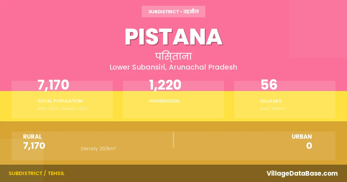
Pistana: A Town and Circle in Lower Subansiri district
District → Lower Subansiri
State → Arunachal Pradesh
Pistana is a town and Circle in the Lower Subansiri district of the Arunachal Pradesh. In India, a Circle is a subdivision of a district responsible for the administration and revenue collection of a specific area within the district. Circles play a crucial role in the local governance structure, contributing significantly to the development and administration of their communities.
According to the 2011 census The total area of Pistana Circle is 364 km², with a population of 7170 people. The population density is 20 inhabitants per square kilometre, and there are approximately 1220 houses in the sub district.
Pistana Circle comprises about 56 villages. Below is a list of these villages along with information about their respective gram panchayats and the nearest town:
| # | Village Name | Gram Panchayat | Nearest Town |
|---|---|---|---|
| 1 | Ambam | Ambam | Yazali (50 km) |
| 2 | Bello | Ziro (91 km) | |
| 3 | Bentam | Ziro (90 km) | |
| 4 | Beram | Rupa (228 km) | |
| 5 | Bikh | Kugi Tago | Zior (70 km) |
| 6 | Dapo Geka | Neelam | Ziro (45 km) |
| 7 | Deed | Ziro (50 km) | |
| 8 | Dem I | Ziro (59 km) | |
| 9 | Dem Ii | Ziro (60 km) | |
| 10 | Dem Iii | Pistana | |
| 11 | Dora | Ambam | Yazali (50 km) |
| 12 | Ekhataya | Radhpu | Ziro (60 km) |
| 13 | Hitu | Shally | Rupa (240 km) |
| 14 | Khach | Ziro (51 km) | |
| 15 | Khowoo | Ziro (55 km) | |
| 16 | Korli | Shally | Rupa (240 km) |
| 17 | Kugitago | Kugi Tago | Ziro (64 km) |
| 18 | Kulu Tago | Pistana | |
| 19 | Lai | Zior (80 km) | |
| 20 | Libia | Yoglu | Yachuli (45 km) |
| 21 | Miya | Hapoli (140 km) | |
| 22 | Mudo | Pistana | |
| 23 | Murta | Ziro (47 km) | |
| 24 | Namko Deed | Deed | Ziro (52 km) |
| 25 | Neelam | Neelam | Ziro (45 km) |
| 26 | Neri | Seya | Ziro (55 km) |
| 27 | Neuliber | Ziro (56 km) | |
| 28 | New Moya | Yazali (50 km) | |
| 29 | New Neelam | Neelam | Ziro (45 km) |
| 30 | New Paniya | Pania | Ziro (42 km) |
| 31 | New Poru | Rupa (235 km) | |
| 32 | Oram Geko | Dem | Ziro (60 km) |
| 33 | Paniya | Pania | Ziro (46 km) |
| 34 | Pinru | Ziro (68 km) | |
| 35 | Pistana H Q | Shally | Pistana |
| 36 | Pochu | Yoglu | Yachuli (45 km) |
| 37 | Poru | Rupa (240 km) | |
| 38 | Radhpu | Radhpu | Ziro (65 km) |
| 39 | Rher | Radhpu | Ziro (60 km) |
| 40 | Ruech Geka | Rupa (237 km) | |
| 41 | Sally | Shally | Rupa (235 km) |
| 42 | Sarak | Pistana | |
| 43 | Sekhe | Pistana | |
| 44 | Seya | Ziro (47 km) | |
| 45 | Seya Ii | Ziro (55 km) | |
| 46 | Sito | Yazali (35 km) | |
| 47 | Takha | Ziro (90 km) | |
| 48 | Tako | Belo | Ziro (89 km) |
| 49 | Talo Yorda | Dem | Pistana |
| 50 | Tapa Happa | Ziro (61 km) | |
| 51 | Tepi | Sitho | Pistana |
| 52 | Tod | Ziro (69 km) | |
| 53 | Tom | Kugi Tago | Ziro (66 km) |
| 54 | Yebin | Yachuli (55 km) | |
| 55 | Yebin Lebir | Pistana | |
| 56 | Yoglu | Yoglu | Yachuli (45 km) |
The population is distributed between urban and rural areas as follows:
| Particulars | Rural | Urban | Total |
|---|---|---|---|
| Total Population | 7170 | 0 | 7170 |
| Male Population | 3539 | 0 | 3539 |
| Female Population | 3631 | 0 | 3631 | Population Density | 20 / km² | 20 / km² |
The distribution of households in the Pistana is:
| Rural Households | Urban Households | Total Households |
|---|---|---|
| 1220 | 0 | 1220 |
Q: What is Pistana?
A: Pistana is a town and in the Lower Subansiri district of the Arunachal Pradesh.
Q: What is the total area of Pistana Circle?
A: The total area of Pistana Circle is 364 km².
Q: What is the population of Pistana Circle according to the 2011 census?
A: According to the 2011 census, the population of Pistana Circle is 7170.
Q: What is the population density of Pistana Circle?
A: The population density of Pistana Circle is 20 inhabitants per square kilometre.
Q: How many houses are there in Pistana Circle?
A: There are approximately 1220 houses in Pistana Circle.
Q: How many villages are there in Pistana Circle?
A: There are about 56 villages in Pistana Circle.
Q: Which is the largest village by population in Pistana Circle?
A: The largest village by population in Pistana Circle is Deed, with 363 people.
Q: Which is the smallest village by population in Pistana Circle?
A: The smallest village by population in Pistana Circle is Ruech Geka, with 34 people.
Q: Which is the largest village by area in Pistana Circle?
A: The largest village by area in Pistana Circle is Tom, with 200 km².
Q: Which is the smallest village by area in Pistana Circle?
A: The smallest village by area in Pistana Circle is Ambam, with 0 km².
Q: What is the population distribution between urban and rural areas in Pistana Circle?
A: The population distribution in Pistana Circle is entirely rural, with a total rural population of 7170.
Q: What is the male population of Pistana Circle?
A: The male population of Pistana Circle is 3539.
Q: What is the female population of Pistana Circle?
A: The female population of Pistana Circle is 3631.
Q: How is the household distribution in Pistana Circle?
A: The household distribution in Pistana Circle is entirely rural, with a total of 1220 households.
Q: How many villages in Pistana Circle have a population of less than 100?
A: There are 25 villages in Pistana Circle with a population of less than 100.
Q: How many villages in Pistana Circle have a population between 100 and 499?
A: There are 31 villages in Pistana Circle with a population between 100 and 499.
| Total Population | Villages in Sub District Of Pistana |
|---|---|
| Less than 100 | 25 |
| 100-499 | 31 |