Yazali: A Town and Circle in Lower Subansiri district
District → Lower Subansiri
State → Arunachal Pradesh
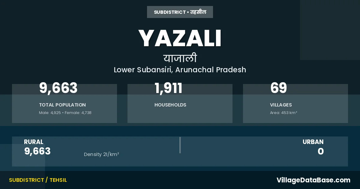
Yazali is a town and Circle in the Lower Subansiri district of the Arunachal Pradesh. In India, a Circle is a subdivision of a district responsible for the administration and revenue collection of a specific area within the district. Circles play a crucial role in the local governance structure, contributing significantly to the development and administration of their communities.
According to the 2011 census The total area of Yazali Circle is 453 km², with a population of 9663 people. The population density is 21 inhabitants per square kilometre, and there are approximately 1911 houses in the sub district.
Yazali Circle comprises about 69 villages. Below is a list of these villages along with information about their respective gram panchayats and the nearest town:
| # | Village Name | Gram Panchayat | Nearest Town |
|---|---|---|---|
| 1 | Amgi | Ziro (50 km) | |
| 2 | Bilo | Ziro (43 km) | |
| 3 | Chod | Yazali | |
| 4 | Chulyu | Ziro (51 km) | |
| 5 | Comp | Ziro (63 km) | |
| 6 | Dapogeka | Yazali | |
| 7 | Dee Happa | Yazali | |
| 8 | Dekh | Yazali (4 km) | |
| 9 | Deli | Ziro (82 km) | |
| 10 | Depo | Ziro (59 km) | |
| 11 | Did | Yazali | |
| 12 | Dillipaji | Ziro (62 km) | |
| 13 | Dodo | North Lakhimpur (108 km) | |
| 14 | Dyuk Happa | Yazali | |
| 15 | Emchi | Rupa (371 km) | |
| 16 | Howu Happa | Rupa (362 km) | |
| 17 | Kamcho | Hapoli (14 km) | |
| 18 | Kamcho Taram | Pitapool (10 km) | |
| 19 | Kebi | Ziro (80 km) | |
| 20 | Khompu | Yazali | |
| 21 | Khompu Nyoli | Yazali (10 km) | |
| 22 | Komru | Ziro (44 km) | |
| 23 | Kotu Nampam | Yazali | |
| 24 | Kuch Kut | Ziro (58 km) | |
| 25 | Lichi Ochi | Ziro (39 km) | |
| 26 | Lichlit | Ziro (88 km) | |
| 27 | Loly | Ziro (60 km) | |
| 28 | Machin | Ziro (44 km) | |
| 29 | Mego | Yazali | |
| 30 | Moob Happa | Ziro (40 km) | |
| 31 | Namdum Nampum | Yazali (3 km) | |
| 32 | Neepco Complex | Yazali | |
| 33 | New Pitapool | Yazali | |
| 34 | New Yazali | Ziro (35 km) | |
| 35 | Nyllo | Ziro (44 km) | |
| 36 | Paa Yorda | Rupa (371 km) | |
| 37 | Pagha Putu | Yazali (1 km) | |
| 38 | Pakhi | Ziro (57 km) | |
| 39 | Parmaar | Yazali (7 km) | |
| 40 | Peji Tabi | Yazali | |
| 41 | Pekir Passa | Ziro (44 km) | |
| 42 | Peni | Ziro (51 km) | |
| 43 | Phop | Rupa (376 km) | |
| 44 | Pitapool | Ziro (47 km) | |
| 45 | Pith | Ziro (69 km) | |
| 46 | Pogi Happa | Rupa (376 km) | |
| 47 | Polu Happa | Yazali | |
| 48 | Possa | Yazali | |
| 49 | Potin | Ziro (56 km) | |
| 50 | Rewa Deli | Yazali | |
| 51 | Rub | Ziro (51 km) | |
| 52 | Rubde | Rubdi | Yazali |
| 53 | Rubdi | Rupa (380 km) | |
| 54 | Seer | Yazali (18 km) | |
| 55 | Seer Hou | Yazali (5 km) | |
| 56 | Sellew | Ziro (47 km) | |
| 57 | Sikhe | Ziro(hapoli) (80 km) | |
| 58 | Swry Daaga | Ziro (40 km) | |
| 59 | Tabi | Ziro (73 km) | |
| 60 | Tadosilly | Ziro (61 km) | |
| 61 | Takampassa | Ziro (45 km) | |
| 62 | Taoh | Rupa (378 km) | |
| 63 | Tekir | Yazali | |
| 64 | Tepin Happa | Yazali (8 km) | |
| 65 | Thowu | Yazali (10 km) | |
| 66 | Toll | Ziro (60 km) | |
| 67 | Trattabi | Yazali | |
| 68 | Yaizat | Yazali | |
| 69 | Yazali | Ziro (35 km) |
The population is distributed between urban and rural areas as follows:
| Particulars | Rural | Urban | Total |
|---|---|---|---|
| Total Population | 9663 | 0 | 9663 |
| Male Population | 4925 | 0 | 4925 |
| Female Population | 4738 | 0 | 4738 | Population Density | 21 / km² | 21 / km² |
The distribution of households in the Yazali is:
| Rural Households | Urban Households | Total Households |
|---|---|---|
| 1911 | 0 | 1911 |
Q: What is Yazali?
A: Yazali is a town and in the Lower Subansiri district of the Arunachal Pradesh.
Q: What is the total area of Yazali Circle?
A: The total area of Yazali Circle is 453 km².
Q: What is the population of Yazali Circle according to the 2011 census?
A: According to the 2011 census, the population of Yazali Circle is 9663.
Q: What is the population density of Yazali Circle?
A: The population density of Yazali Circle is 21 inhabitants per square kilometre.
Q: How many houses are there in Yazali Circle?
A: There are approximately 1911 houses in Yazali Circle.
Q: How many villages are there in Yazali Circle?
A: There are about 69 villages in Yazali Circle.
Q: Which is the largest village by population in Yazali Circle?
A: The largest village by population in Yazali Circle is Yazali, with 1768 people.
Q: Which is the smallest village by population in Yazali Circle?
A: The smallest village by population in Yazali Circle is Dapogeka, with 0 people.
Q: Which is the largest village by area in Yazali Circle?
A: The largest village by area in Yazali Circle is Chulyu, with 90000 km².
Q: Which is the smallest village by area in Yazali Circle?
A: The smallest village by area in Yazali Circle is Dee Happa, with 0 km².
Q: What is the population distribution between urban and rural areas in Yazali Circle?
A: The population distribution in Yazali Circle is entirely rural, with a total rural population of 9663.
Q: What is the male population of Yazali Circle?
A: The male population of Yazali Circle is 4925.
Q: What is the female population of Yazali Circle?
A: The female population of Yazali Circle is 4738.
Q: How is the household distribution in Yazali Circle?
A: The household distribution in Yazali Circle is entirely rural, with a total of 1911 households.
Q: How many villages in Yazali Circle have a population of less than 100?
A: There are 38 villages in Yazali Circle with a population of less than 100.
Q: How many villages in Yazali Circle have a population between 100 and 499?
A: There are 27 villages in Yazali Circle with a population between 100 and 499.
Q: How many villages in Yazali Circle have a population between 500 and 999?
A: There are 3 villages in Yazali Circle with a population between 500 and 999.
Q: How many villages in Yazali Circle have a population between 1000 and 1999?
A: There are 1 villages in Yazali Circle with a population between 1000 and 1999.
| Total Population | Villages in Sub District Of Yazali |
|---|---|
| Less than 100 | 38 |
| 100-499 | 27 |
| 500-999 | 3 |
| 1000-1999 | 1 |