KITPI CIRCLE: A Town and Circle in Tawang district
District → Tawang
State → Arunachal Pradesh
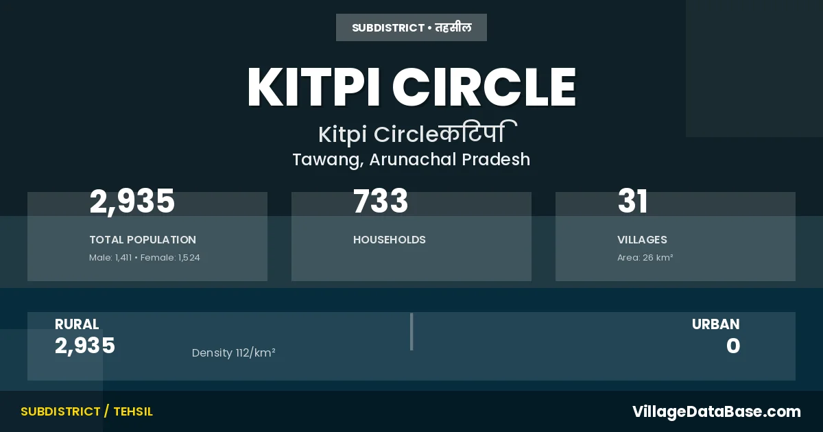
KITPI CIRCLE is a town and Circle in the Tawang district of the Arunachal Pradesh. In India, a Circle is a subdivision of a district responsible for the administration and revenue collection of a specific area within the district. Circles play a crucial role in the local governance structure, contributing significantly to the development and administration of their communities.
According to the 2011 census The total area of KITPI CIRCLE Circle is 26 km², with a population of 2935 people. The population density is 112 inhabitants per square kilometre, and there are approximately 733 houses in the sub district.
KITPI CIRCLE Circle comprises about 31 villages. Below is a list of these villages along with information about their respective gram panchayats and the nearest town:
| # | Village Name | Gram Panchayat | Nearest Town |
|---|---|---|---|
| 1 | Audung | Kitpi | Tawang (26 km) |
| 2 | Bathung | Jamkhar | Tawang (23 km) |
| 3 | Beghar | Jamkhar | Tawang (22 km) |
| 4 | Boimkang | Tawang (17 km) | |
| 5 | Boksar | Khardung | Tawang (25 km) |
| 6 | Bomdir Basti | Lagong | Tawang (17 km) |
| 7 | Bongbong Chaksam | Tawang (34 km) | |
| 8 | Bragyap | Tawang (20 km) | |
| 9 | Grenghar | Shernup | Tawang (39 km) |
| 10 | Jamkhar | Jamkhar | Tawang (24 km) |
| 11 | Jyarmang Ani Gonpa | Tawang (17 km) | |
| 12 | Khardung | Khardung | Tawang (32 km) |
| 13 | Khrimu | Khrimu Meith | Tawang (22 km) |
| 14 | Khromten Gonpa | Tawang (22 km) | |
| 15 | Kitpi | Kitpi | Tawang (23 km) |
| 16 | Kitpi Ii | Kitpi | Tawang (23 km) |
| 17 | Kralling | Khrimu Meith | Tawang (24 km) |
| 18 | Langateng | Jamkhar | Tawang (23 km) |
| 19 | Langbutse | Lagong | Tawang (16 km) |
| 20 | Lhargong | Shernup | Tawang (35 km) |
| 21 | Namet | Lagong | Tawang (13 km) |
| 22 | Namtungtse | Tawang (12 km) | |
| 23 | Ruighar | Jamkhar | Tawang (25 km) |
| 24 | Shernup | Shernup | Tawang (31 km) |
| 25 | Soma | Khardung | Tawang (25 km) |
| 26 | Tarmang Gonpa | Tawang (18 km) | |
| 27 | Tengteng | Shernup | Tawang (35 km) |
| 28 | Themkhar | Jamkhar | Tawang (22 km) |
| 29 | Thongmin Gonpa | Tawang (30 km) | |
| 30 | Waikher | Tawang (18 km) | |
| 31 | Zyemteng | Tawang (11 km) |
The population is distributed between urban and rural areas as follows:
| Particulars | Rural | Urban | Total |
|---|---|---|---|
| Total Population | 2935 | 0 | 2935 |
| Male Population | 1411 | 0 | 1411 |
| Female Population | 1524 | 0 | 1524 | Population Density | 112 / km² | 112 / km² |
The distribution of households in the KITPI CIRCLE is:
| Rural Households | Urban Households | Total Households |
|---|---|---|
| 733 | 0 | 733 |
Q: What is KITPI CIRCLE?
A: KITPI CIRCLE is a town and in the Tawang district of the Arunachal Pradesh.
Q: What is the total area of KITPI CIRCLE Circle?
A: The total area of KITPI CIRCLE Circle is 26 km².
Q: What is the population of KITPI CIRCLE Circle according to the 2011 census?
A: According to the 2011 census, the population of KITPI CIRCLE Circle is 2935.
Q: What is the population density of KITPI CIRCLE Circle?
A: The population density of KITPI CIRCLE Circle is 112 inhabitants per square kilometre.
Q: How many houses are there in KITPI CIRCLE Circle?
A: There are approximately 733 houses in KITPI CIRCLE Circle.
Q: How many villages are there in KITPI CIRCLE Circle?
A: There are about 31 villages in KITPI CIRCLE Circle.
Q: Which is the largest village by population in KITPI CIRCLE Circle?
A: The largest village by population in KITPI CIRCLE Circle is Khrimu, with 596 people.
Q: Which is the smallest village by population in KITPI CIRCLE Circle?
A: The smallest village by population in KITPI CIRCLE Circle is Khromten Gonpa, with 2 people.
Q: Which is the largest village by area in KITPI CIRCLE Circle?
A: The largest village by area in KITPI CIRCLE Circle is Audung, with 0 km².
Q: Which is the smallest village by area in KITPI CIRCLE Circle?
A: The smallest village by area in KITPI CIRCLE Circle is Audung, with 0 km².
Q: What is the population distribution between urban and rural areas in KITPI CIRCLE Circle?
A: The population distribution in KITPI CIRCLE Circle is entirely rural, with a total rural population of 2935.
Q: What is the male population of KITPI CIRCLE Circle?
A: The male population of KITPI CIRCLE Circle is 1411.
Q: What is the female population of KITPI CIRCLE Circle?
A: The female population of KITPI CIRCLE Circle is 1524.
Q: How is the household distribution in KITPI CIRCLE Circle?
A: The household distribution in KITPI CIRCLE Circle is entirely rural, with a total of 733 households.
Q: How many villages in KITPI CIRCLE Circle have a population of less than 100?
A: There are 21 villages in KITPI CIRCLE Circle with a population of less than 100.
Q: How many villages in KITPI CIRCLE Circle have a population between 100 and 499?
A: There are 9 villages in KITPI CIRCLE Circle with a population between 100 and 499.
Q: How many villages in KITPI CIRCLE Circle have a population between 500 and 999?
A: There are 1 villages in KITPI CIRCLE Circle with a population between 500 and 999.
| Total Population | Villages in Sub District Of KITPI CIRCLE |
|---|---|
| Less than 100 | 21 |
| 100-499 | 9 |
| 500-999 | 1 |