Kalaktang: A Town and Circle in West Kameng district
District → West Kameng
State → Arunachal Pradesh
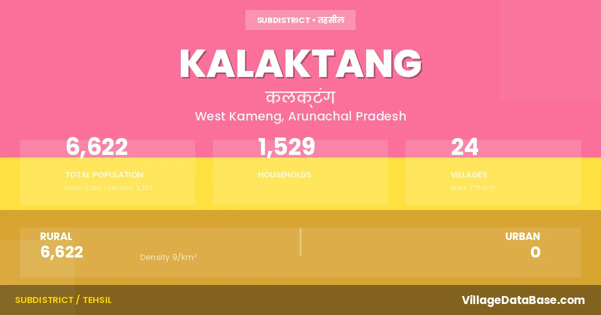
Kalaktang is a town and Circle in the West Kameng district of the Arunachal Pradesh. In India, a Circle is a subdivision of a district responsible for the administration and revenue collection of a specific area within the district. Circles play a crucial role in the local governance structure, contributing significantly to the development and administration of their communities.
According to the 2011 census The total area of Kalaktang Circle is 775 km², with a population of 6622 people. The population density is 9 inhabitants per square kilometre, and there are approximately 1529 houses in the sub district.
Kalaktang Circle comprises about 24 villages. Below is a list of these villages along with information about their respective gram panchayats and the nearest town:
| # | Village Name | Gram Panchayat | Nearest Town |
|---|---|---|---|
| 1 | 700 Chain Pwd Labour Camp | Rupa (94 km) | |
| 2 | 900 Chain Pwd Labour Camp | Rupa (94 km) | |
| 3 | Ankalin Pwd Rwd Labour Camp | Rupa (90 km) | |
| 4 | Ankalin Village | Angkaling | Rupa (94 km) |
| 5 | Betchilling | Lungdur | Kalaktang |
| 6 | Boha | Boha | Rupa (98 km) |
| 7 | Brokpalangchen | Liphakpu | Rupa (97 km) |
| 8 | Chingi | Chingi | Bomdila (115 km) |
| 9 | Dengzi | Denzi | Rupa (85 km) |
| 10 | Domkho | Domkho | Bomdila (76 km) |
| 11 | Kalaktang H Q | Kalaktang | Rupa (82 km) |
| 12 | Kalaktang Village | Kalaktang | Rupa (80 km) |
| 13 | Kamallangchen | Kalaktang | Bomdila (88 km) |
| 14 | Lazala Gompa | Bomdila (88 km) | |
| 15 | Liphakpu | Liphakpu | Rupa (97 km) |
| 16 | Lungdur | Lungdur | Kalaktang |
| 17 | Morshing | Morsing | Bomdila (80 km) |
| 18 | Rongthangjurpam | Rangthajorpam | Rupa (94 km) |
| 19 | Samphung | Kalaktang | Bomdila (95 km) |
| 20 | Samteng | Rupa (49 km) | |
| 21 | Sanglem | Bomdila (83 km) | |
| 22 | Sumdrung | Warrangpam Samdrung | Bomdila (131 km) |
| 23 | Warrangpam | Warrangpam Samdrung | Bomdila (125 km) |
| 24 | Weizer | Denzi | Rupa (84 km) |
The population is distributed between urban and rural areas as follows:
| Particulars | Rural | Urban | Total |
|---|---|---|---|
| Total Population | 6622 | 0 | 6622 |
| Male Population | 3369 | 0 | 3369 |
| Female Population | 3253 | 0 | 3253 | Population Density | 9 / km² | 9 / km² |
The distribution of households in the Kalaktang is:
| Rural Households | Urban Households | Total Households |
|---|---|---|
| 1529 | 0 | 1529 |
Q: What is Kalaktang?
A: Kalaktang is a town and in the West Kameng district of the Arunachal Pradesh.
Q: What is the total area of Kalaktang Circle?
A: The total area of Kalaktang Circle is 775 km².
Q: What is the population of Kalaktang Circle according to the 2011 census?
A: According to the 2011 census, the population of Kalaktang Circle is 6622.
Q: What is the population density of Kalaktang Circle?
A: The population density of Kalaktang Circle is 9 inhabitants per square kilometre.
Q: How many houses are there in Kalaktang Circle?
A: There are approximately 1529 houses in Kalaktang Circle.
Q: How many villages are there in Kalaktang Circle?
A: There are about 24 villages in Kalaktang Circle.
Q: Which is the largest village by population in Kalaktang Circle?
A: The largest village by population in Kalaktang Circle is Kalaktang H Q, with 2089 people.
Q: Which is the smallest village by population in Kalaktang Circle?
A: The smallest village by population in Kalaktang Circle is 700 Chain Pwd Labour Camp, with 5 people.
Q: Which is the largest village by area in Kalaktang Circle?
A: The largest village by area in Kalaktang Circle is Morshing, with 660 km².
Q: Which is the smallest village by area in Kalaktang Circle?
A: The smallest village by area in Kalaktang Circle is 700 Chain Pwd Labour Camp, with 0 km².
Q: What is the population distribution between urban and rural areas in Kalaktang Circle?
A: The population distribution in Kalaktang Circle is entirely rural, with a total rural population of 6622.
Q: What is the male population of Kalaktang Circle?
A: The male population of Kalaktang Circle is 3369.
Q: What is the female population of Kalaktang Circle?
A: The female population of Kalaktang Circle is 3253.
Q: How is the household distribution in Kalaktang Circle?
A: The household distribution in Kalaktang Circle is entirely rural, with a total of 1529 households.
Q: How many villages in Kalaktang Circle have a population of less than 100?
A: There are 5 villages in Kalaktang Circle with a population of less than 100.
Q: How many villages in Kalaktang Circle have a population between 100 and 499?
A: There are 17 villages in Kalaktang Circle with a population between 100 and 499.
Q: How many villages in Kalaktang Circle have a population between 500 and 999?
A: There are 1 villages in Kalaktang Circle with a population between 500 and 999.
Q: How many villages in Kalaktang Circle have a population between 2000 and 2999?
A: There is 1 village in Kalaktang Circle with a population between 2000 and 2999.
| Total Population | Villages in Sub District Of Kalaktang |
|---|---|
| Less than 100 | 5 |
| 100-499 | 17 |
| 500-999 | 1 |
| 2000-2999 | 1 |