District → West Kameng
State → Arunachal Pradesh
Rupa is a town and Circle in the West Kameng district of the Arunachal Pradesh. In India, a Circle is a subdivision of a district responsible for the administration and revenue collection of a specific area within the district. Circles play a crucial role in the local governance structure, contributing significantly to the development and administration of their communities.
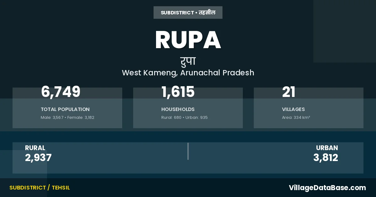
According to the 2011 census The total area of Rupa Circle is 334 km², with a population of 6749 people. The population density is 20 inhabitants per square kilometre, and there are approximately 1615 houses in the sub district.
Rupa Circle comprises about 21 villages. Below is a list of these villages along with information about their respective gram panchayats and the nearest town:
| # | Village Name | Gram Panchayat | Nearest Town |
|---|---|---|---|
| 1 | Aktam Thungre | Rupa (10 km) | |
| 2 | Boock | Rupa (6 km) | |
| 3 | Brokpublang | Rupa (5 km) | |
| 4 | Chhikrimu | Rupa (5 km) | |
| 5 | Chillipam | Rupa (15 km) | |
| 6 | Dakahng | Rupa (7 km) | |
| 7 | Dikshipam | Rupa (17 km) | |
| 8 | Dringshingpam | Rupa (12 km) | |
| 9 | Dukumpani | Rupa (12 km) | |
| 10 | Durga Mandir | Rupa (15 km) | |
| 11 | Gachambow | Rupa (7 km) | |
| 12 | Garbow | Rupa (12 km) | |
| 13 | Jungpam | Rupa (7 km) | |
| 14 | Khangpam | Rupa (12 km) | |
| 15 | Lumbaktang | Lumbaktang | Rupa (25 km) |
| 16 | Membachur | Mukuthing | Rupa (25 km) |
| 17 | Mukuthing | Mukuthing | Rupa (18 km) |
| 18 | Rupa | Rupa | |
| 19 | Thungri | Thungri | Rupa (10 km) |
| 20 | Zekmasu Thekan | Rupa (5 km) | |
| 21 | Zomoje | Rupa (1 km) |
The population is distributed between urban and rural areas as follows:
| Particulars | Rural | Urban | Total |
|---|---|---|---|
| Total Population | 2937 | 3812 | 6749 |
| Male Population | 1521 | 2046 | 3567 |
| Female Population | 1416 | 1766 | 3182 | Population Density | 20 / km² |
The distribution of households in the Rupa is:
| Rural Households | Urban Households | Total Households |
|---|---|---|
| 680 | 935 | 1615 |
Q: What is Rupa?
A: Rupa is a town and in the West Kameng district of the Arunachal Pradesh.
Q: What is the total area of Rupa Circle?
A: The total area of Rupa Circle is 334 km².
Q: What is the population of Rupa Circle according to the 2011 census?
A: According to the 2011 census, the population of Rupa Circle is 6749.
Q: What is the population density of Rupa Circle?
A: The population density of Rupa Circle is 20 inhabitants per square kilometre.
Q: How many houses are there in Rupa Circle?
A: There are approximately 1615 houses in Rupa Circle.
Q: How many villages are there in Rupa Circle?
A: There are about 21 villages in Rupa Circle.
Q: Which is the largest village by population in Rupa Circle?
A: The largest village by population in Rupa Circle is Chillipam, with 415 people.
Q: Which is the smallest village by population in Rupa Circle?
A: The smallest village by population in Rupa Circle is Rupa, with 0 people.
Q: Which is the largest village by area in Rupa Circle?
A: The largest village by area in Rupa Circle is Membachur, with 105 km².
Q: Which is the smallest village by area in Rupa Circle?
A: The smallest village by area in Rupa Circle is Rupa, with 0 km².
Q: What is the male population of Rupa Circle?
A: The male population of Rupa Circle is 3567.
Q: What is the female population of Rupa Circle?
A: The female population of Rupa Circle is 3182.
Q: How many villages in Rupa Circle have a population of less than 100?
A: There are 9 villages in Rupa Circle with a population of less than 100.
Q: How many villages in Rupa Circle have a population between 100 and 499?
A: There are 12 villages in Rupa Circle with a population between 100 and 499.
| Total Population | Villages in Sub District Of Rupa |
|---|---|
| Less than 100 | 9 |
| 100-499 | 12 |