Monigong: A Town and Circle in West Siang district
District → West Siang
State → Arunachal Pradesh
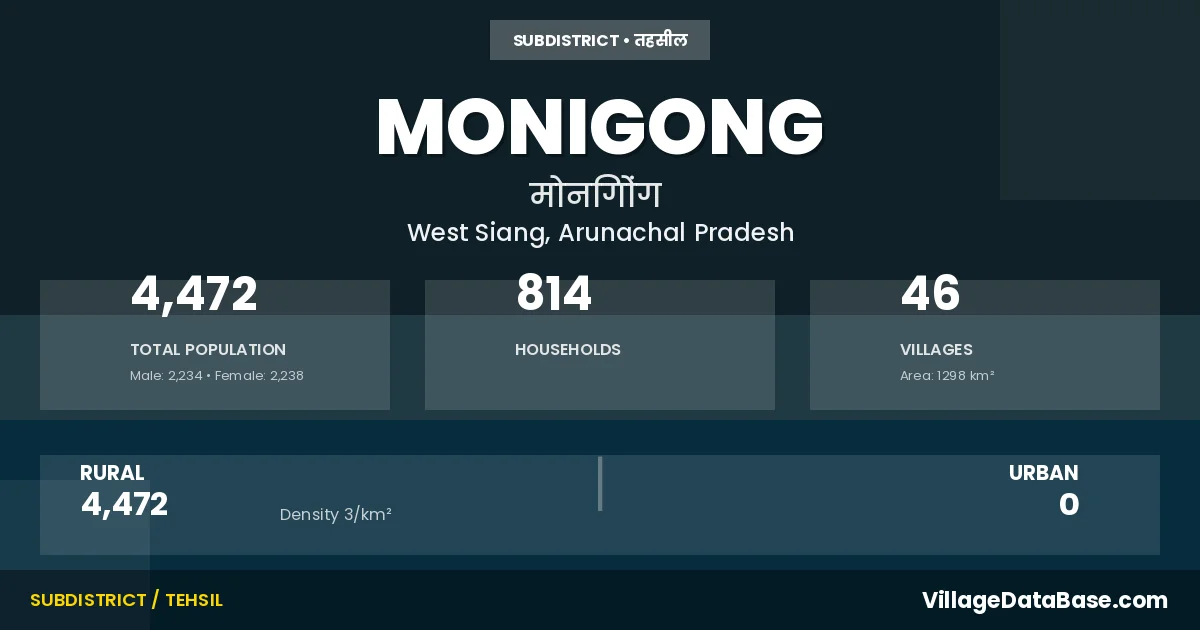
Monigong is a town and Circle in the West Siang district of the Arunachal Pradesh. In India, a Circle is a subdivision of a district responsible for the administration and revenue collection of a specific area within the district. Circles play a crucial role in the local governance structure, contributing significantly to the development and administration of their communities.
According to the 2011 census The total area of Monigong Circle is 1298 km², with a population of 4472 people. The population density is 3 inhabitants per square kilometre, and there are approximately 814 houses in the sub district.
Monigong Circle comprises about 46 villages. Below is a list of these villages along with information about their respective gram panchayats and the nearest town:
| # | Village Name | Gram Panchayat | Nearest Town |
|---|---|---|---|
| 1 | Changrang | Saji I | Monigong (15 km) |
| 2 | Chingo | Monigong (16 km) | |
| 3 | Damsong | Monigong (8 km) | |
| 4 | Dipu | Dunyo Ii | Monigong (10 km) |
| 5 | Gahglong | Dunyo I | Monigong (7 km) |
| 6 | Gapur | Dunyo Ii | Monigong (4 km) |
| 7 | Geching | Tamang Ii | Monigong (14 km) |
| 8 | Gekar | Monigong (9 km) | |
| 9 | Hemi | Hedo Hemi | Monigong (18 km) |
| 10 | Jereling | Ningiohedo | Monigong (7 km) |
| 11 | Kambe Dom | Monigong (10 km) | |
| 12 | Karle | Hedo Hemi | Monigong (10 km) |
| 13 | Komte | Monigong (19 km) | |
| 14 | Korle | Monigong (5 km) | |
| 15 | Kote Sokong | Monigong (4 km) | |
| 16 | Labukar | Saji Iii | Monigong (13 km) |
| 17 | Lusing Yingbe | Monigong (12 km) | |
| 18 | Monigong H Q | Monigong | Mechuka (110 km) |
| 19 | Nema Sibo | Saji I | Monigong (18 km) |
| 20 | Panglum | Dunyo I | Monigong (5 km) |
| 21 | Pangri | Monigong (27 km) | |
| 22 | Paning | Monigong (8 km) | |
| 23 | Pape Krong | Saji I | Monigong (16 km) |
| 24 | Pepu Nute | Monigong (10 km) | |
| 25 | Pongte | Tamang I | Monigong (9 km) |
| 26 | Pullom | Saji Iii | Monigong (6 km) |
| 27 | Puning | Dunyo I | Monigong (1 km) |
| 28 | Ramo Sumi | Monigong (20 km) | |
| 29 | Remang Village | Saji Iv | Monigong (7 km) |
| 30 | Ruku | Monigong (3 km) | |
| 31 | Saline | Monigong (1 km) | |
| 32 | Sejigong | Saji Iv | Monigong (4 km) |
| 33 | Sheet | Tamang I | Monigong (21 km) |
| 34 | Sijak | Tamang Ii | Monigong (22 km) |
| 35 | Simuging | Saji Iii | Monigong (13 km) |
| 36 | Singbu | Tamang I | Monigong (12 km) |
| 37 | Soyorgong | Monigong (14 km) | |
| 38 | Sukudom | Saji Iii | Monigong (10 km) |
| 39 | Tabha | Monigong (27 km) | |
| 40 | Takinglitak | Monigong (20 km) | |
| 41 | Talamying | Hedo Hemi | Monigong (18 km) |
| 42 | Tanghak Yingkiong | Monigong (14 km) | |
| 43 | Tasum | Saji Ii | Monigong (14 km) |
| 44 | Yadang | Monigong (2 km) | |
| 45 | Yangrang | Monigong (17 km) | |
| 46 | Yorkodom | Saji Ii | Monigong (15 km) |
The population is distributed between urban and rural areas as follows:
| Particulars | Rural | Urban | Total |
|---|---|---|---|
| Total Population | 4472 | 0 | 4472 |
| Male Population | 2234 | 0 | 2234 |
| Female Population | 2238 | 0 | 2238 | Population Density | 3 / km² | 3 / km² |
The distribution of households in the Monigong is:
| Rural Households | Urban Households | Total Households |
|---|---|---|
| 814 | 0 | 814 |
Q: What is Monigong?
A: Monigong is a town and in the West Siang district of the Arunachal Pradesh.
Q: What is the total area of Monigong Circle?
A: The total area of Monigong Circle is 1298 km².
Q: What is the population of Monigong Circle according to the 2011 census?
A: According to the 2011 census, the population of Monigong Circle is 4472.
Q: What is the population density of Monigong Circle?
A: The population density of Monigong Circle is 3 inhabitants per square kilometre.
Q: How many houses are there in Monigong Circle?
A: There are approximately 814 houses in Monigong Circle.
Q: How many villages are there in Monigong Circle?
A: There are about 46 villages in Monigong Circle.
Q: Which is the largest village by population in Monigong Circle?
A: The largest village by population in Monigong Circle is Monigong H Q, with 588 people.
Q: Which is the smallest village by population in Monigong Circle?
A: The smallest village by population in Monigong Circle is Sijak, with 15 people.
Q: Which is the largest village by area in Monigong Circle?
A: The largest village by area in Monigong Circle is Changrang, with 0 km².
Q: Which is the smallest village by area in Monigong Circle?
A: The smallest village by area in Monigong Circle is Changrang, with 0 km².
Q: What is the population distribution between urban and rural areas in Monigong Circle?
A: The population distribution in Monigong Circle is entirely rural, with a total rural population of 4472.
Q: What is the male population of Monigong Circle?
A: The male population of Monigong Circle is 2234.
Q: What is the female population of Monigong Circle?
A: The female population of Monigong Circle is 2238.
Q: How is the household distribution in Monigong Circle?
A: The household distribution in Monigong Circle is entirely rural, with a total of 814 households.
Q: How many villages in Monigong Circle have a population of less than 100?
A: There are 32 villages in Monigong Circle with a population of less than 100.
Q: How many villages in Monigong Circle have a population between 100 and 499?
A: There are 13 villages in Monigong Circle with a population between 100 and 499.
Q: How many villages in Monigong Circle have a population between 500 and 999?
A: There are 1 villages in Monigong Circle with a population between 500 and 999.
| Total Population | Villages in Sub District Of Monigong |
|---|---|
| Less than 100 | 32 |
| 100-499 | 13 |
| 500-999 | 1 |