Rumgong: A Town and Circle in West Siang district
District → West Siang
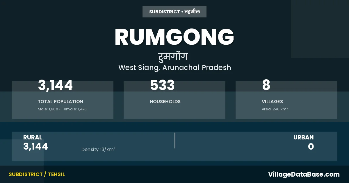
State → Arunachal Pradesh
Rumgong is a town and Circle in the West Siang district of the Arunachal Pradesh. In India, a Circle is a subdivision of a district responsible for the administration and revenue collection of a specific area within the district. Circles play a crucial role in the local governance structure, contributing significantly to the development and administration of their communities.
According to the 2011 census The total area of Rumgong Circle is 246 km², with a population of 3144 people. The population density is 13 inhabitants per square kilometre, and there are approximately 533 houses in the sub district.
Rumgong Circle comprises about 8 villages. Below is a list of these villages along with information about their respective gram panchayats and the nearest town:
| # | Village Name | Gram Panchayat | Nearest Town |
|---|---|---|---|
| 1 | Bingung | Bingung | Rumgong |
| 2 | Jomo | Jomo I | Rumgong |
| 3 | Molom | Rumgong | |
| 4 | Mopung | Mopung | Rumgong |
| 5 | Rumgong | Rumgong | |
| 6 | Rumgong H Q | Rumgong | |
| 7 | Yasing | Yosing | Rumgong |
| 8 | Yogong | Yogong | Rumgong |
The population is distributed between urban and rural areas as follows:
| Particulars | Rural | Urban | Total |
|---|---|---|---|
| Total Population | 3144 | 0 | 3144 |
| Male Population | 1668 | 0 | 1668 |
| Female Population | 1476 | 0 | 1476 | Population Density | 13 / km² | 13 / km² |
The distribution of households in the Rumgong is:
| Rural Households | Urban Households | Total Households |
|---|---|---|
| 533 | 0 | 533 |
Q: What is Rumgong?
A: Rumgong is a town and in the West Siang district of the Arunachal Pradesh.
Q: What is the total area of Rumgong Circle?
A: The total area of Rumgong Circle is 246 km².
Q: What is the population of Rumgong Circle according to the 2011 census?
A: According to the 2011 census, the population of Rumgong Circle is 3144.
Q: What is the population density of Rumgong Circle?
A: The population density of Rumgong Circle is 13 inhabitants per square kilometre.
Q: How many houses are there in Rumgong Circle?
A: There are approximately 533 houses in Rumgong Circle.
Q: How many villages are there in Rumgong Circle?
A: There are about 8 villages in Rumgong Circle.
Q: Which is the largest village by population in Rumgong Circle?
A: The largest village by population in Rumgong Circle is Jomo, with 722 people.
Q: Which is the smallest village by population in Rumgong Circle?
A: The smallest village by population in Rumgong Circle is Yogong, with 224 people.
Q: Which is the largest village by area in Rumgong Circle?
A: The largest village by area in Rumgong Circle is Bingung, with 0 km².
Q: Which is the smallest village by area in Rumgong Circle?
A: The smallest village by area in Rumgong Circle is Bingung, with 0 km².
Q: What is the population distribution between urban and rural areas in Rumgong Circle?
A: The population distribution in Rumgong Circle is entirely rural, with a total rural population of 3144.
Q: What is the male population of Rumgong Circle?
A: The male population of Rumgong Circle is 1668.
Q: What is the female population of Rumgong Circle?
A: The female population of Rumgong Circle is 1476.
Q: How is the household distribution in Rumgong Circle?
A: The household distribution in Rumgong Circle is entirely rural, with a total of 533 households.
Q: How many villages in Rumgong Circle have a population between 100 and 499?
A: There are 6 villages in Rumgong Circle with a population between 100 and 499.
Q: How many villages in Rumgong Circle have a population between 500 and 999?
A: There are 2 villages in Rumgong Circle with a population between 500 and 999.
| Total Population | Villages in Sub District Of Rumgong |
|---|---|
| 100-499 | 6 |
| 500-999 | 2 |