District → West Siang
State → Arunachal Pradesh
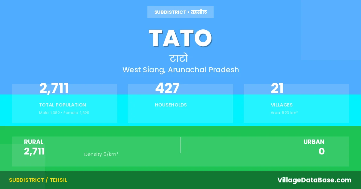
Tato is a town and Circle in the West Siang district of the Arunachal Pradesh. In India, a Circle is a subdivision of a district responsible for the administration and revenue collection of a specific area within the district. Circles play a crucial role in the local governance structure, contributing significantly to the development and administration of their communities.
According to the 2011 census The total area of Tato Circle is 523 km², with a population of 2711 people. The population density is 5 inhabitants per square kilometre, and there are approximately 427 houses in the sub district.
Tato Circle comprises about 21 villages. Below is a list of these villages along with information about their respective gram panchayats and the nearest town:
| # | Village Name | Gram Panchayat | Nearest Town |
|---|---|---|---|
| 1 | Charu | Tado Gitu Yapu Charu Lipo | Tato |
| 2 | Gai | Tubung Balijan | Aalo (100 km) |
| 3 | Hone | Tagur Quying Heyo Pabuying | Aalo (95 km) |
| 4 | Irgo | Irgo | Aalo (112 km) |
| 5 | Kamging | Aalo (130 km) | |
| 6 | Kammo | Aalo (130 km) | |
| 7 | Lipo | Tado Gitu Yapu Charu Lipo | Aalo (102 km) |
| 8 | Lower Heyo | Aalo (140 km) | |
| 9 | Pabuying | Tagur Quying Heyo Pabuying | Aalo (146 km) |
| 10 | Paum | Yapik Paum | Aalo (94 km) |
| 11 | Pene | Aalo (91 km) | |
| 12 | Quing | Tagur Quying Heyo Pabuying | Tato |
| 13 | Road Labour Camp | Aalo (105 km) | |
| 14 | Tadogita | Tado Gitu Yapu Charu Lipo | Aalo (109 km) |
| 15 | Tagur | Tagur Quying Heyo Pabuying | Aalo (123 km) |
| 16 | Tato H Q | Gemotali Yaki | Aalo (130 km) |
| 17 | Tato Village | Gemotali Yaki | Aalo (131 km) |
| 18 | Upper Heyo | Aalo (135 km) | |
| 19 | V B Camp | Aalo (145 km) | |
| 20 | Yapik | Yapik Paum | Aalo (106 km) |
| 21 | Yapu | Tado Gitu Yapu Charu Lipo | Aalo (114 km) |
The population is distributed between urban and rural areas as follows:
| Particulars | Rural | Urban | Total |
|---|---|---|---|
| Total Population | 2711 | 0 | 2711 |
| Male Population | 1382 | 0 | 1382 |
| Female Population | 1329 | 0 | 1329 | Population Density | 5 / km² | 5 / km² |
The distribution of households in the Tato is:
| Rural Households | Urban Households | Total Households |
|---|---|---|
| 427 | 0 | 427 |
Q: What is Tato?
A: Tato is a town and in the West Siang district of the Arunachal Pradesh.
Q: What is the total area of Tato Circle?
A: The total area of Tato Circle is 523 km².
Q: What is the population of Tato Circle according to the 2011 census?
A: According to the 2011 census, the population of Tato Circle is 2711.
Q: What is the population density of Tato Circle?
A: The population density of Tato Circle is 5 inhabitants per square kilometre.
Q: How many houses are there in Tato Circle?
A: There are approximately 427 houses in Tato Circle.
Q: How many villages are there in Tato Circle?
A: There are about 21 villages in Tato Circle.
Q: Which is the largest village by population in Tato Circle?
A: The largest village by population in Tato Circle is Tato H Q, with 748 people.
Q: Which is the smallest village by population in Tato Circle?
A: The smallest village by population in Tato Circle is Charu, with 0 people.
Q: Which is the largest village by area in Tato Circle?
A: The largest village by area in Tato Circle is Charu, with 0 km².
Q: Which is the smallest village by area in Tato Circle?
A: The smallest village by area in Tato Circle is Charu, with 0 km².
Q: What is the population distribution between urban and rural areas in Tato Circle?
A: The population distribution in Tato Circle is entirely rural, with a total rural population of 2711.
Q: What is the male population of Tato Circle?
A: The male population of Tato Circle is 1382.
Q: What is the female population of Tato Circle?
A: The female population of Tato Circle is 1329.
Q: How is the household distribution in Tato Circle?
A: The household distribution in Tato Circle is entirely rural, with a total of 427 households.
Q: How many villages in Tato Circle have a population of less than 100?
A: There are 12 villages in Tato Circle with a population of less than 100.
Q: How many villages in Tato Circle have a population between 100 and 499?
A: There are 8 villages in Tato Circle with a population between 100 and 499.
Q: How many villages in Tato Circle have a population between 500 and 999?
A: There are 1 villages in Tato Circle with a population between 500 and 999.
| Total Population | Villages in Sub District Of Tato |
|---|---|
| Less than 100 | 12 |
| 100-499 | 8 |
| 500-999 | 1 |