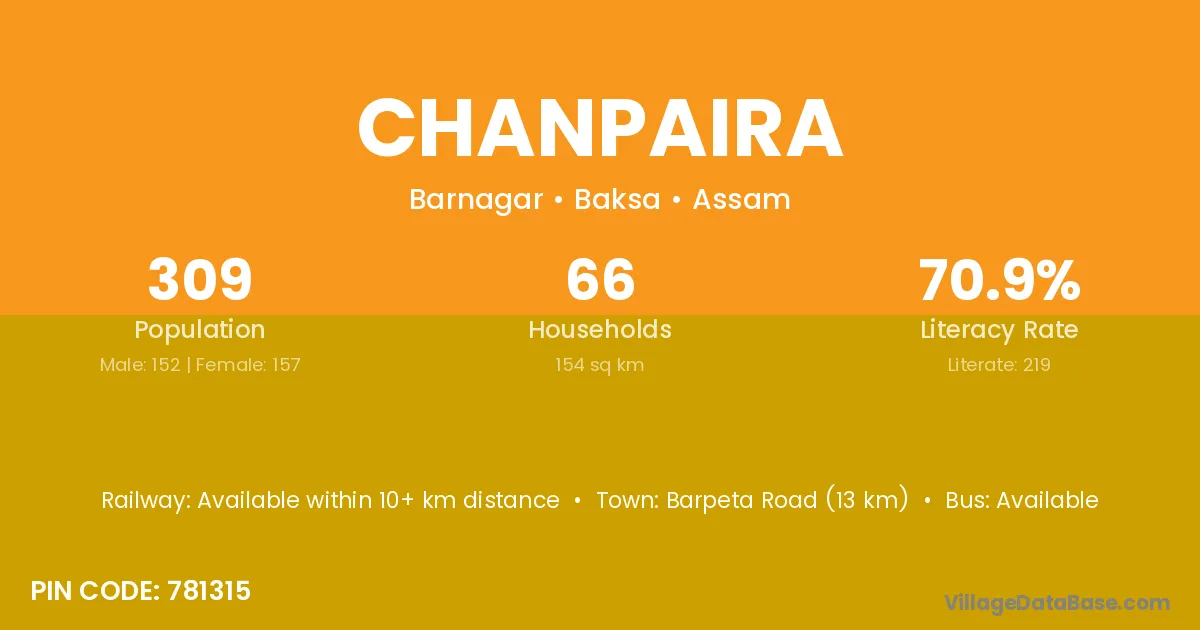
Chanpaira village is located in the Barnagar Subdivision of the Baksa district in Assam .
Block / Subdivision → Barnagar
District → Baksa
State → Assam
According to Census 2011 information, the village code of Chanpaira village is 781315.
Chanpaira village has a total population of 309 people, of which 152 are males and 157 are females.
The literacy rate of Chanpaira village is 70.87%. Male literacy stands at 80.92% and female literacy at 61.15%.
There are approximately 66 households in Chanpaira village.
Barpeta Road (13 km) is the nearest town to Chanpaira village for major economic activities and is located approximately 13 km away.
The population of Chanpaira village is distributed between literate and illiterate residents as follows:
| Particulars | Male | Female | Total |
|---|---|---|---|
| Literate | 123 | 96 | 219 |
| Illiterate | 29 | 61 | 90 |
| Total | 152 | 157 | 309 |
Source: Census 2011
| Village | District |
|---|---|
| Barghopa Bilar Pathar | Baksa |
| Bhakuamari | Baksa |
| Bhakuamari | Barpeta |
| Bhakuamari | Dhubri |
| Bhakuamari | Kokrajhar |
| Bhala Pukhuri | Baksa |
| Bunmaja Gaon | Baksa |
| Bunmaja Pathar | Baksa |
| Dalogaon | Baksa |
| Dhekiajani Gaon | Baksa |
| Dhekiajani Pathar | Baksa |
| Kachugaon | Baksa |
| Kachugaon | Golaghat |
| Kawaimari | Baksa |
| Kawaimari | Darrang |
| Kawaimari | Dhemaji |
| Kawaimari | Nagaon |
| Kawaimari | Nagaon |
| Kawaimari | Nagaon |
| Nimua | Baksa |
| Nimua | Barpeta |
| Nimua | Ranchi |
No reviews yet. Be the first to review this village!
Available within 10+ km distance
Available within village
Available within 5 - 10 km distance