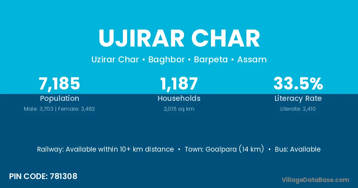
Ujirar Char village is located in the Baghbor Subdivision of the Barpeta district in Assam .
Block / Subdivision → Baghbor
District → Barpeta
State → Assam
According to Census 2011 information, the village code of Ujirar Char village is 781308.
Ujirar Char village has a total population of 7,185 people, of which 3,703 are males and 3,482 are females.
The literacy rate of Ujirar Char village is 33.54%. Male literacy stands at 36.54% and female literacy at 30.36%.
There are approximately 1,187 households in Ujirar Char village.
Goalpara (14 km) is the nearest town to Ujirar Char village for major economic activities and is located approximately 14 km away.
The population of Ujirar Char village is distributed between literate and illiterate residents as follows:
| Particulars | Male | Female | Total |
|---|---|---|---|
| Literate | 1,353 | 1,057 | 2,410 |
| Illiterate | 2,350 | 2,425 | 4,775 |
| Total | 3,703 | 3,482 | 7,185 |
Source: Census 2011
| Village | District |
|---|---|
| Balikuri Pam | Barpeta |
| Chapari Gaon | Barpeta |
| Chapari Pathar | Barpeta |
| Jahanar Gaon | Barpeta |
| Kalgachi | Barpeta |
| Kalpani N C | Barpeta |
| Kapah Toli | Barpeta |
| Matha Ranga | Barpeta |
| Mowkhowa Char N C | Barpeta |
| Rowmari | Baksa |
| Rowmari | Barpeta |
| Rowmari | Chirang |
| Rowmari | Darrang |
| Rowmari | Goalpara |
| Rowmari | Nagaon |
| Rowmari | Sonitpur |
| Rowmari | Udalguri |
| Tekla Chuti | Barpeta |
No reviews yet. Be the first to review this village!
Available within 10+ km distance
Available within village
Available within 5 - 10 km distance