Pathorighat: A Town and Subdivision in Darrang district
District → Darrang
State → Assam
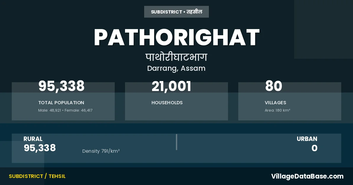
Pathorighat is a town and Subdivision in the Darrang district of the Assam. In India, a Subdivision is a subdivision of a district responsible for the administration and revenue collection of a specific area within the district. Subdivisions play a crucial role in the local governance structure, contributing significantly to the development and administration of their communities.
According to the 2011 census The total area of Pathorighat Subdivision is 180 km², with a population of 95338 people. The population density is 791 inhabitants per square kilometre, and there are approximately 21001 houses in the sub district.
Pathorighat Subdivision comprises about 80 villages. Below is a list of these villages along with information about their respective gram panchayats and the nearest town:
| # | Village Name | Gram Panchayat | Nearest Town |
|---|---|---|---|
| 1 | Alikhapara | Mangaldai (12 km) | |
| 2 | Athkuria | Pathorighat | |
| 3 | Bagachala | Chengeliajhar | Mangaldai (27 km) |
| 4 | Baghmarapukhuri | Chengeliajhar | Mangaldai (20 km) |
| 5 | Bairagipara | Mangaldai (15 km) | |
| 6 | Balikuchi | Pathorighat | |
| 7 | Baneikuchi | Mangaldai (20 km) | |
| 8 | Barbari | Mangaldai (35 km) | |
| 9 | Bareri | Mongaldoi (15 km) | |
| 10 | Barkaliajhar | Turai | Mangaldai (10 km) |
| 11 | Barpathar | Duni | Mangaldai (25 km) |
| 12 | Batabari | Mangaldai (18 km) | |
| 13 | Bheruadal | Duni | Mangaldai (22 km) |
| 14 | Bheruadolgaon | Duni | Mangaldai (20 km) |
| 15 | Bihaigaon | Duni | Mangaldai (22 km) |
| 16 | Bishnupur | Burha | Mangaldai (18 km) |
| 17 | Borigaon | Pathorighat | |
| 18 | Burahdaichapara | Burha | Mangaldai (20 km) |
| 19 | Burahkhat | Sarabari | Mangaldai (22 km) |
| 20 | Burhagaon | Burha | Mangaldai (18 km) |
| 21 | Chakarmukh | Burha | Mangaldai (35 km) |
| 22 | Chamukha Dol | Chengeliajhar | Mangaldai (26 km) |
| 23 | Chengapara No 1 | Patharighat | Mangaldai (16 km) |
| 24 | Dagiapara | Mangaldai (22 km) | |
| 25 | Duni | Duni | Mangaldai (21 km) |
| 26 | Durduria | Chengeliajhar | Mangaldai (28 km) |
| 27 | Gangapukhuri | Sarabari | Mangaldai (22 km) |
| 28 | Ghavara | Duni | Mangaldai (25 km) |
| 29 | Ghilakuri | Pathorighat | |
| 30 | Ghopeli | Chengeliajhar | Mangaldai (20 km) |
| 31 | Ghorasal | Turai | Mangaldai (16 km) |
| 32 | Goalpara | Chengeliajhar | Mangaldai (18 km) |
| 33 | Hangalpara | Mangaldai (35 km) | |
| 34 | Haripur | Chengeliajhar | Mangaldai (18 km) |
| 35 | Hirapara | Mongaldoi (12 km) | |
| 36 | Hussain Chuburi | Duni | Mangaldai (22 km) |
| 37 | Jayantipur | Burha | Mangaldai (35 km) |
| 38 | Jayapur | Mangaldai (30 km) | |
| 39 | Kahitali | Mangaldai (25 km) | |
| 40 | Kamargaon | Mangaldai (21 km) | |
| 41 | Kaoikaragaon | Pathorighat | |
| 42 | Karaibari | Mangaldai (25 km) | |
| 43 | Katahi | Sarabari | Mangaldai (22 km) |
| 44 | Kenduguri | Chengeliajhar | Mangaldai (18 km) |
| 45 | Kharkhowapara | Mangaldai (16 km) | |
| 46 | Khasdipila | Mangaldai (18 km) | |
| 47 | Khatara | Mangaldai (20 km) | |
| 48 | Kumarpara | Chengeliajhar | Pathorighat |
| 49 | Lathapara | Sarabari | Mangaldai (24 km) |
| 50 | Lozora | Mangaldai (16 km) | |
| 51 | Maharipara | Mangaldai (25 km) | |
| 52 | Mahtali | Mangaldai (25 km) | |
| 53 | Malibaritari | Mangaldai (35 km) | |
| 54 | Mohaliapara | Mangaldai (15 km) | |
| 55 | Muslimghopa | Ghorabandha | Pathorighat |
| 56 | Nagaon | Mangaldai (20 km) | |
| 57 | Naodingerdal | Burha | Mangaldai (35 km) |
| 58 | Naopota | Chengeliajhar | Mangaldai (27 km) |
| 59 | Naptapara | Sarabari | Mangaldai (25 km) |
| 60 | Niranchuba | Turai | Mangaldai (12 km) |
| 61 | Niz Barampur | Mangaldai (12 km) | |
| 62 | Niz Sarabari | Sarabari | Mangaldai (25 km) |
| 63 | No 2 Chengapara | Ghorabandha | Mangaldai (14 km) |
| 64 | Padmajhar | Burha | Mangaldai (25 km) |
| 65 | Patharighat | Patharighat | Mongaldoi (17 km) |
| 66 | Patidarrang | Mangaldai (16 km) | |
| 67 | Pipirakuchi | Patharighat | Pathorighat |
| 68 | Potapukhuri | Mangaldai (25 km) | |
| 69 | Ramgaon | Mangaldai (18 km) | |
| 70 | Ramraipara | Patharighat | Pathorighat |
| 71 | Sakiapara | Mangaldai (25 km) | |
| 72 | Salikajhar | Mangaldai (35 km) | |
| 73 | Samatiapara | Mangaldai (22 km) | |
| 74 | Sanapatipara | Burhinagar | Mangaldai (15 km) |
| 75 | Santipukhuri | Sarabari | Mangaldai (30 km) |
| 76 | Sarabari Barampur | Mangaldai (13 km) | |
| 77 | Sonarisal | Burha | Mangaldoi (30 km) |
| 78 | Taragaon | Turai | Mangaldai (17 km) |
| 79 | Tengara | Duni | Pathorighat |
| 80 | Titkuchi | Burha | Mangaldai (35 km) |
The population is distributed between urban and rural areas as follows:
| Particulars | Rural | Urban | Total |
|---|---|---|---|
| Total Population | 95338 | 0 | 95338 |
| Male Population | 48921 | 0 | 48921 |
| Female Population | 46417 | 0 | 46417 | Population Density | 791 / km² | 791 / km² |
The distribution of households in the Pathorighat is:
| Rural Households | Urban Households | Total Households |
|---|---|---|
| 21001 | 0 | 21001 |
Q: What is Pathorighat?
A: Pathorighat is a town and in the Darrang district of the Assam.
Q: What is the total area of Pathorighat Subdivision?
A: The total area of Pathorighat Subdivision is 180 km².
Q: What is the population of Pathorighat Subdivision according to the 2011 census?
A: According to the 2011 census, the population of Pathorighat Subdivision is 95338.
Q: What is the population density of Pathorighat Subdivision?
A: The population density of Pathorighat Subdivision is 791 inhabitants per square kilometre.
Q: How many houses are there in Pathorighat Subdivision?
A: There are approximately 21001 houses in Pathorighat Subdivision.
Q: How many villages are there in Pathorighat Subdivision?
A: There are about 80 villages in Pathorighat Subdivision.
Q: Which is the largest village by population in Pathorighat Subdivision?
A: The largest village by population in Pathorighat Subdivision is Muslimghopa, with 2705 people.
Q: Which is the smallest village by population in Pathorighat Subdivision?
A: The smallest village by population in Pathorighat Subdivision is Chamukha Dol, with 159 people.
Q: Which is the largest village by area in Pathorighat Subdivision?
A: The largest village by area in Pathorighat Subdivision is Ghorasal, with 428 km².
Q: Which is the smallest village by area in Pathorighat Subdivision?
A: The smallest village by area in Pathorighat Subdivision is Bihaigaon, with 43 km².
Q: What is the population distribution between urban and rural areas in Pathorighat Subdivision?
A: The population distribution in Pathorighat Subdivision is entirely rural, with a total rural population of 95338.
Q: What is the male population of Pathorighat Subdivision?
A: The male population of Pathorighat Subdivision is 48921.
Q: What is the female population of Pathorighat Subdivision?
A: The female population of Pathorighat Subdivision is 46417.
Q: How is the household distribution in Pathorighat Subdivision?
A: The household distribution in Pathorighat Subdivision is entirely rural, with a total of 21001 households.
Q: How many villages in Pathorighat Subdivision have a population between 100 and 499?
A: There are 5 villages in Pathorighat Subdivision with a population between 100 and 499.
Q: How many villages in Pathorighat Subdivision have a population between 500 and 999?
A: There are 32 villages in Pathorighat Subdivision with a population between 500 and 999.
Q: How many villages in Pathorighat Subdivision have a population between 1000 and 1999?
A: There are 37 villages in Pathorighat Subdivision with a population between 1000 and 1999.
Q: How many villages in Pathorighat Subdivision have a population between 2000 and 2999?
A: There is 6 village in Pathorighat Subdivision with a population between 2000 and 2999.
| Total Population | Villages in Sub District Of Pathorighat |
|---|---|
| 100-499 | 5 |
| 500-999 | 32 |
| 1000-1999 | 37 |
| 2000-2999 | 6 |