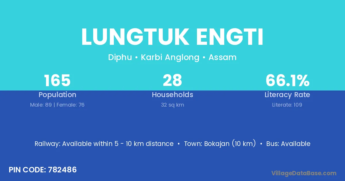
Lungtuk Engti village is located in the Diphu Subdivision of the Karbi Anglong district in Assam .
Block / Subdivision → Diphu
District → Karbi Anglong
State → Assam
According to Census 2011 information, the village code of Lungtuk Engti village is 782486.
Lungtuk Engti village has a total population of 165 people, of which 89 are males and 76 are females.
The literacy rate of Lungtuk Engti village is 66.06%. Male literacy stands at 75.28% and female literacy at 55.26%.
There are approximately 28 households in Lungtuk Engti village.
Bokajan (10 km) is the nearest town to Lungtuk Engti village for major economic activities and is located approximately 10 km away.
The population of Lungtuk Engti village is distributed between literate and illiterate residents as follows:
| Particulars | Male | Female | Total |
|---|---|---|---|
| Literate | 67 | 42 | 109 |
| Illiterate | 22 | 34 | 56 |
| Total | 89 | 76 | 165 |
Source: Census 2011
| Village | District |
|---|---|
| Anjok Teron | Karbi Anglong |
| Chandra Teron | Karbi Anglong |
| Chandra Teron | Karbi Anglong |
| Chandra Teron | Karbi Anglong |
| Habe Timung | Karbi Anglong |
| Kai Terang | Karbi Anglong |
| Kathar Engti | Karbi Anglong |
| Khoken | Karbi Anglong |
| Khoken | Churachandpur |
| Lungtuk Rongpi | Karbi Anglong |
| Maising Timung | Karbi Anglong |
| Ram Nath Kathar | Karbi Anglong |
| Risso Ronghang | Karbi Anglong |
| Sarthe Timung | Karbi Anglong |
| Sarthe Timung | Karbi Anglong |
| Sarthe Timung | Karbi Anglong |
No reviews yet. Be the first to review this village!
Available within 5 - 10 km distance
Available within 10+ km distance
Available within <5 km distance