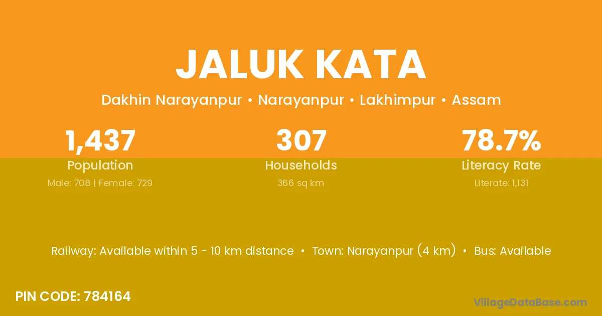
Jaluk Kata village is located in the Narayanpur Subdivision of the Lakhimpur district in Assam .
Block / Subdivision → Narayanpur
District → Lakhimpur
State → Assam
According to Census 2011 information, the village code of Jaluk Kata village is 784164.
Jaluk Kata village has a total population of 1,437 people, of which 708 are males and 729 are females.
The literacy rate of Jaluk Kata village is 78.71%. Male literacy stands at 81.92% and female literacy at 75.58%.
There are approximately 307 households in Jaluk Kata village.
Narayanpur (4 km) is the nearest town to Jaluk Kata village for major economic activities and is located approximately 4 km away.
The population of Jaluk Kata village is distributed between literate and illiterate residents as follows:
| Particulars | Male | Female | Total |
|---|---|---|---|
| Literate | 580 | 551 | 1,131 |
| Illiterate | 128 | 178 | 306 |
| Total | 708 | 729 | 1,437 |
Source: Census 2011
| Village | District |
|---|---|
| Chamaguri | Goalpara |
| Chamaguri | Lakhimpur |
| Chamaguri | Sivasagar |
| Chamaguri | Sonitpur |
| Chamaguri | West Garo Hills |
| Chamaguri | West Garo Hills |
| Dhangulai Pathar | Lakhimpur |
| Duliagaon | Jorhat |
| Duliagaon | Lakhimpur |
| Jalbharia | Lakhimpur |
| No 1 Bahupathar | Lakhimpur |
| No 2 Bahupathar | Lakhimpur |
| No 2 Sonaribari | Lakhimpur |
| No 3 Bahupathar | Lakhimpur |
| No 4 Pichala | Lakhimpur |
| Pichala No 3 | Lakhimpur |
| Raidangia | Dibrugarh |
| Raidangia | Lakhimpur |
No reviews yet. Be the first to review this village!
Available within 5 - 10 km distance
Available within <5 km distance
Available within village