District → Aurangabad
Aurangabad is a district in the Bihar of India. Covering a total area of 3305 km², Aurangabad is home to a population of 2540073 people as per the 2011 census. The district has a population density of 769 inhabitants per square kilometre and comprises about 391898 houses. district includes approximately 1742 villages.
For administrative purposes, the Aurangabad district is divided into Subdivisions, Blocks, Police Stations (PS), and Community Development Blocks (C.D.Blocks). In India, a C.D.Block represents the next level of administrative division after the Subdivision in many regions. Its important to note that in some Indian states, C.D.Blocks are synonymous with Subdivisions.
A C.D.Block is a designated rural area for administration and development in India. It is managed by a Block Development Officer (BDO) and encompasses several gram panchayats, which are local administrative units at the village level.
The largest Subdivision in Aurangabad district is Nabinagar, which spans an area of 546 km², while Haspura is the smallest Subdivision with an area of 143 km². Rafiganj is also the most populous Subdivision with 312367 people, whereas Haspura is the least populous with 160820 people. There are 11 Subdivisions in Aurangabad district.
| # | Subdivisions(CD Block) | Area (km²) | Population (2011) | Density (km²) |
|---|---|---|---|---|
| 1 | Aurangabad | 269 | 283193 | 1,052 |
| 2 | Barun | 313 | 200052 | 640 |
| 3 | Daudnagar | 184 | 206854 | 1,122 |
| 4 | Deo | 276 | 173216 | 628 |
| 5 | Goh | 305 | 234400 | 768 |
| 6 | Haspura | 143 | 160820 | 1,128 |
| 7 | Kutumba | 255 | 226599 | 890 |
| 8 | Madanpur | 358 | 211329 | 591 |
| 9 | Nabinagar | 546 | 305236 | 559 |
| 10 | Obra | 270 | 226007 | 838 |
| 11 | Rafiganj | 388 | 312367 | 806 |
The population is distributed between urban and rural areas as follows:
| Particulars | Rural | Urban | Total |
|---|---|---|---|
| Total Population | 2303219 | 236854 | 2540073 |
| Male Population | 1194619 | 124065 | 1318684 |
| Female Population | 1108600 | 112789 | 1221389 | Population Density | 710 / km² | 3891 / km² | 769 / km² |
The distribution of households in the Aurangabad is:
| Rural Households | Urban Households | Total Households |
|---|---|---|
| 355036 | 36862 | 391898 |
Showing 2 of 2 places
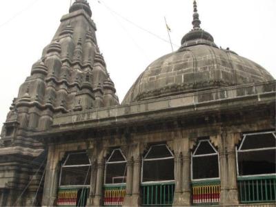
The Vishnupada Mandir, Bihar is a prominent Temple dedicated to Lord Vishnu located in Jagaya, Aurangabad, Bihar, India
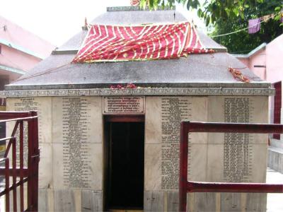
The Mangla Gauri Temple, Bihar is a prominent Temple dedicated to Bihar located in Jagaya, Aurangabad, Bihar, India. Th
Q: What is the total area of Aurangabad district?
A: The total area of Aurangabad district is 3305 km².
Q: What is the population of Aurangabad district according to the 2011 census?
A: According to the 2011 census, the population of Aurangabad district is 2540073.
Q: How many villages are there in Aurangabad district?
A: There are approximately 1742 villages in Aurangabad district.
Q: What is the population density of Aurangabad district?
A: The population density of Aurangabad district is 769 inhabitants per square kilometre.
Q: How many houses are there in Aurangabad district?
A: There are about 391898 houses in Aurangabad district.
Q: How is the Aurangabad district administratively divided?
A: For administrative purposes, Aurangabad district is divided into Subdivisions, Blocks, Police Stations (PS), and Community Development Blocks (C.D.Blocks).
Q: What is a C.D.Block in India?
A: A C.D.Block (Community Development Block) is a designated rural area for administration and development in India, managed by a Block Development Officer (BDO) and encompassing several gram panchayats.
Q: Which is the largest Subdivision in Aurangabad district by area?
A: The largest Subdivision in Aurangabad district by area is Nabinagar, which spans an area of 546 km².
Q: Which is the smallest Subdivision in Aurangabad district by area?
A: The smallest Subdivision in Aurangabad district by area is Haspura, with an area of 143 km².
Q: Which Subdivision in Aurangabad district has the largest population?
A: The Subdivision with the largest population in Aurangabad district is Rafiganj, with a population of 312367 people.
Q: Which Subdivision in Aurangabad district has the smallest population?
A: The Subdivision with the smallest population in Aurangabad district is , with a population of 160820 people.
Q: How many Subdivisions are there in Aurangabad district?
A: There are 11 Subdivisions in Aurangabad district.
Q: What is the male population of Aurangabad district?
A: The male population of Aurangabad district is 20,727.
Q: What is the female population of Aurangabad district?
A: The female population of Aurangabad district is 16,115.
Q: How many villages in Aurangabad district have a population of less than 100?
A: There are 125 villages in Aurangabad district with a population of less than 100.
Q: How many villages in Aurangabad district have a population between 100 and 499?
A: There are 370 villages in Aurangabad district with a population between 100 and 499.
Q: How many villages in Aurangabad district have a population between 500 and 999?
A: There are 486 villages in Aurangabad district with a population between 500 and 999.
Q: How many villages in Aurangabad district have a population between 1000 and 1999?
A: There are 466 villages in Aurangabad district with a population between 1000 and 1999.
Q: How many villages in Aurangabad district have a population between 2000 and 2999?
A: There is 151 village in Aurangabad district with a population between 2000 and 2999.
Q: How many villages in Aurangabad district have a population between 3000 and 3999?
A: There is 65 village in Aurangabad district with a population between 3000 and 3999.
Q: How many villages in Aurangabad district have a population between 4000 and 4999?
A: There is 32 village in Aurangabad district with a population between 4000 and 4999.
Q: How many villages in Aurangabad district have a population of 5000 and above?
A: There is 40 village in Aurangabad district with a population of 5000 and above.
| Total Population | Villages in Sub District Of Aurangabad |
|---|---|
| Less than 100 | 125 |
| 100-499 | 370 |
| 500-999 | 486 |
| 1000-1999 | 466 |
| 2000-2999 | 151 |
| 3000-3999 | 65 |
| 4000-4999 | 32 |
| 5000 And Above | 40 |