Biraul: A Town and Subdivision in Darbhanga district
District → Darbhanga
State → Bihar
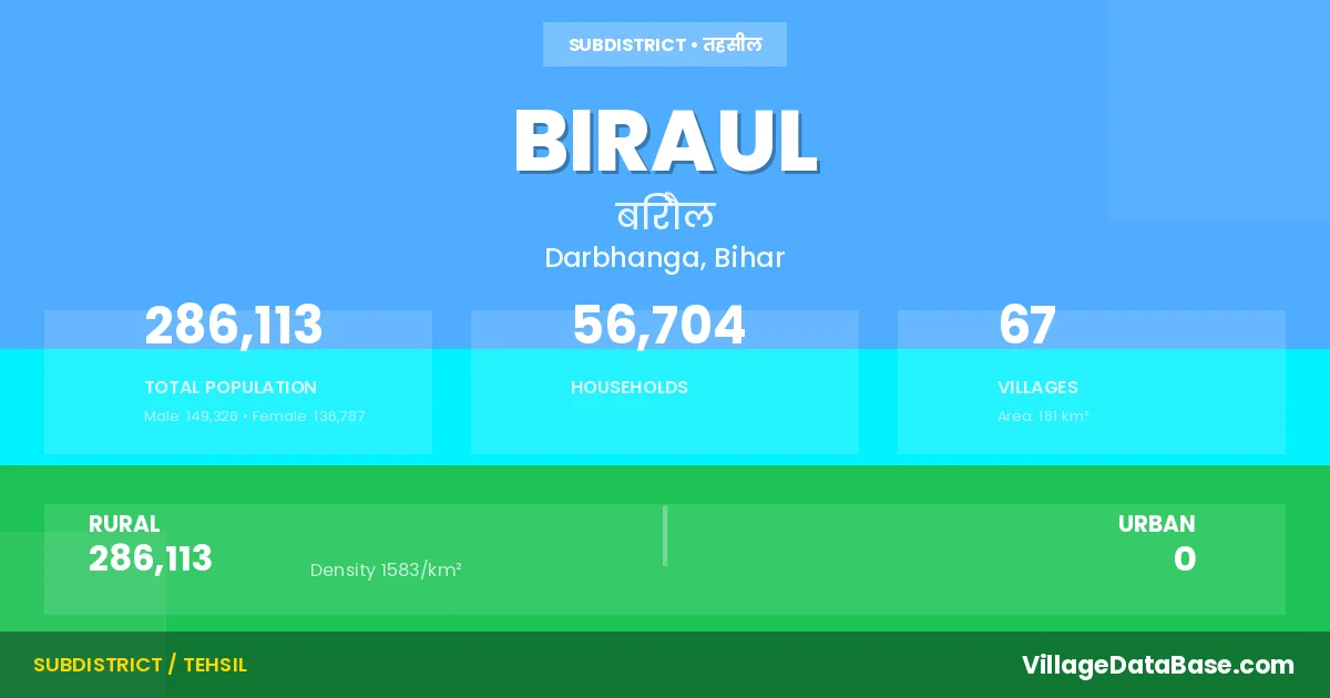
Biraul is a town and Subdivision in the Darbhanga district of the Bihar. In India, a Subdivision is a subdivision of a district responsible for the administration and revenue collection of a specific area within the district. Subdivisions play a crucial role in the local governance structure, contributing significantly to the development and administration of their communities.
According to the 2011 census The total area of Biraul Subdivision is 181 km², with a population of 286113 people. The population density is 1,583 inhabitants per square kilometre, and there are approximately 56704 houses in the sub district.
Biraul Subdivision comprises about 67 villages. Below is a list of these villages along with information about their respective gram panchayats and the nearest town:
| # | Village Name | Gram Panchayat | Nearest Town |
|---|---|---|---|
| 1 | Afzala | Afzala | Darbhanga (40 km) |
| 2 | Akbarpur Baik | Akbarpur Benk | Darbhanga (50 km) |
| 3 | Andhiari | Dekuli Jagnathpur | Darbhanga (37 km) |
| 4 | Aran Pokhram | Pokhram North | Biraul |
| 5 | Arjuna Bijulia | Manor Bhauram | Darbanga (38 km) |
| 6 | Athar | Sahasram | Darbhanga (42 km) |
| 7 | Auranga Usuri | Arga Usari | Darbhanga (30 km) |
| 8 | Awan | Manor Bhauram | Darbhanga (40 km) |
| 9 | Az Rakbe Gobindpur | Dumari | Darbhanga (48 km) |
| 10 | Balia | Dumari | Darbhanga (48 km) |
| 11 | Banpur | Bairampur | Biraul |
| 12 | Belgaun | Ramnagar | Darbhanga (44 km) |
| 13 | Bhaini | Pataniya | Darbhanga (44 km) |
| 14 | Bhanta | Supaul | Darbhanga (48 km) |
| 15 | Birampur | Bairampur | Darbhanga (41 km) |
| 16 | Changwara | Ladaho | Darbhanga (44 km) |
| 17 | Deokali | Dekuli Jagnathpur | Darbhanga (35 km) |
| 18 | Dumri | Dumari | Darbhanga (48 km) |
| 19 | Fakirana | Biraul | Darbhanga (42 km) |
| 20 | Gambhiria | Kamarkala | Darbhanga (41 km) |
| 21 | Gaura | Arga Usari | Darbanga (30 km) |
| 22 | Gayri | Biraul | Darbhanga (43 km) |
| 23 | Golma | Biraul | Biraul |
| 24 | Hanshi | Bairampur | Darbhanga (41 km) |
| 25 | Hanti | Uchati | Darbhanga (48 km) |
| 26 | Harpatti Gobindpur | Dumari | Darbhanga (48 km) |
| 27 | Harpur Kalan | Kamarkala | Darbhanga (41 km) |
| 28 | Jagarnathpur | Dekuli Jagnathpur | Darbhanga (35 km) |
| 29 | Jagdispur | Kahua | Darbhanga (40 km) |
| 30 | Jaikishunpur | Bairampur | Darbhanga (25 km) |
| 31 | Kahuwa | Kahua | Darbhanga (40 km) |
| 32 | Kamar Kalan | Kamarkala | Darbhanga (41 km) |
| 33 | Kataya | Ladaho | Darbhanga (45 km) |
| 34 | Ladha | Ladaho | Darbhanga (44 km) |
| 35 | Lalpur | Pataniya | Darbhanga (44 km) |
| 36 | Mahamadpur | Ladaho | Darbhanga (44 km) |
| 37 | Mahua | Sahasram | Darbhanga (42 km) |
| 38 | Manorbhoram | Manor Bhauram | Darbhanga (37 km) |
| 39 | Mirzapur | Bairampur | Darbhanga (41 km) |
| 40 | Murwara | Arga Usari | Darbanga (30 km) |
| 41 | Naraenpur | Pataniya | Biraul |
| 42 | Nathpatti | Dumari | Biraul |
| 43 | Nausta | Ganaura Tarwara | Darbhanga (50 km) |
| 44 | Nayanagar | Sahasram | Biraul |
| 45 | Neuri | Neuri | Darbhanga (39 km) |
| 46 | Padri | Parri | Darbhanga (40 km) |
| 47 | Paghari | Sonpur Paghari | Darbhanga (50 km) |
| 48 | Pakhram | Pokhram North | Darbhanga (45 km) |
| 49 | Parhat | Biraul | Darbhanga (42 km) |
| 50 | Patania | Pataniya | Darbhanga (44 km) |
| 51 | Ramnagar | Ramnagar | Darbhanga (44 km) |
| 52 | Rampur | Sahasram | Darbhanga (44 km) |
| 53 | Rasulpur | Kamarkala | Darbhanga (41 km) |
| 54 | Rohar | Bhawanipur | Darbhanga (40 km) |
| 55 | Saduka | Pataniya | Darbhanga (44 km) |
| 56 | Sahasram | Sahasram | Darbhanga (45 km) |
| 57 | Saho | Ganaura Tarwara | Darbhanga (40 km) |
| 58 | Shiunagar | Itwa Shiv Nagar | Darbhanga (45 km) |
| 59 | Shiwpur | Ganaura Tarwara | Darbhanga (50 km) |
| 60 | Sihol | Itwa Shiv Nagar | Darbhanga (45 km) |
| 61 | Sirsia | Ganaura Tarwara | Darbhanga (50 km) |
| 62 | Sogaha | Kamarkala | Darbhanga (41 km) |
| 63 | Sonbihat | Rohar Mahmuda | Darbhanga (40 km) |
| 64 | Sonpur | Sonpur Paghari | Darbhanga (49 km) |
| 65 | Supaul | Biraul | Darbhanga (42 km) |
| 66 | Talibpur | Kamarkala | Darbhanga (41 km) |
| 67 | Uchti | Uchati | Darbhanga (50 km) |
The population is distributed between urban and rural areas as follows:
| Particulars | Rural | Urban | Total |
|---|---|---|---|
| Total Population | 286113 | 0 | 286113 |
| Male Population | 149326 | 0 | 149326 |
| Female Population | 136787 | 0 | 136787 | Population Density | 1583 / km² | 1,583 / km² |
The distribution of households in the Biraul is:
| Rural Households | Urban Households | Total Households |
|---|---|---|
| 56704 | 0 | 56704 |
Q: What is Biraul?
A: Biraul is a town and in the Darbhanga district of the Bihar.
Q: What is the total area of Biraul Subdivision?
A: The total area of Biraul Subdivision is 181 km².
Q: What is the population of Biraul Subdivision according to the 2011 census?
A: According to the 2011 census, the population of Biraul Subdivision is 286113.
Q: What is the population density of Biraul Subdivision?
A: The population density of Biraul Subdivision is 1,583 inhabitants per square kilometre.
Q: How many houses are there in Biraul Subdivision?
A: There are approximately 56704 houses in Biraul Subdivision.
Q: How many villages are there in Biraul Subdivision?
A: There are about 67 villages in Biraul Subdivision.
Q: Which is the largest village by population in Biraul Subdivision?
A: The largest village by population in Biraul Subdivision is Pakhram, with 28209 people.
Q: Which is the smallest village by population in Biraul Subdivision?
A: The smallest village by population in Biraul Subdivision is Aran Pokhram, with 0 people.
Q: Which is the largest village by area in Biraul Subdivision?
A: The largest village by area in Biraul Subdivision is Saho, with 1862 km².
Q: Which is the smallest village by area in Biraul Subdivision?
A: The smallest village by area in Biraul Subdivision is Aran Pokhram, with 13 km².
Q: What is the population distribution between urban and rural areas in Biraul Subdivision?
A: The population distribution in Biraul Subdivision is entirely rural, with a total rural population of 286113.
Q: What is the male population of Biraul Subdivision?
A: The male population of Biraul Subdivision is 149326.
Q: What is the female population of Biraul Subdivision?
A: The female population of Biraul Subdivision is 136787.
Q: How is the household distribution in Biraul Subdivision?
A: The household distribution in Biraul Subdivision is entirely rural, with a total of 56704 households.
Q: How many villages in Biraul Subdivision have a population of less than 100?
A: There are 7 villages in Biraul Subdivision with a population of less than 100.
Q: How many villages in Biraul Subdivision have a population between 100 and 499?
A: There are 5 villages in Biraul Subdivision with a population between 100 and 499.
Q: How many villages in Biraul Subdivision have a population between 500 and 999?
A: There are 6 villages in Biraul Subdivision with a population between 500 and 999.
Q: How many villages in Biraul Subdivision have a population between 1000 and 1999?
A: There are 15 villages in Biraul Subdivision with a population between 1000 and 1999.
Q: How many villages in Biraul Subdivision have a population between 2000 and 2999?
A: There is 4 village in Biraul Subdivision with a population between 2000 and 2999.
Q: How many villages in Biraul Subdivision have a population between 3000 and 3999?
A: There is 7 village in Biraul Subdivision with a population between 3000 and 3999.
Q: How many villages in Biraul Subdivision have a population between 4000 and 4999?
A: There is 6 village in Biraul Subdivision with a population between 4000 and 4999.
Q: How many villages in Biraul Subdivision have a population of 5000 and above?
A: There is 17 village in Biraul Subdivision with a population of 5000 and above.
| Total Population | Villages in Sub District Of Biraul |
|---|---|
| Less than 100 | 7 |
| 100-499 | 5 |
| 500-999 | 6 |
| 1000-1999 | 15 |
| 2000-2999 | 4 |
| 3000-3999 | 7 |
| 4000-4999 | 6 |
| 5000 And Above | 17 |