Hayaghat: A Town and Subdivision in Darbhanga district
District → Darbhanga
State → Bihar
Hayaghat is a town and Subdivision in the Darbhanga district of the Bihar. In India, a Subdivision is a subdivision of a district responsible for the administration and revenue collection of a specific area within the district. Subdivisions play a crucial role in the local governance structure, contributing significantly to the development and administration of their communities.
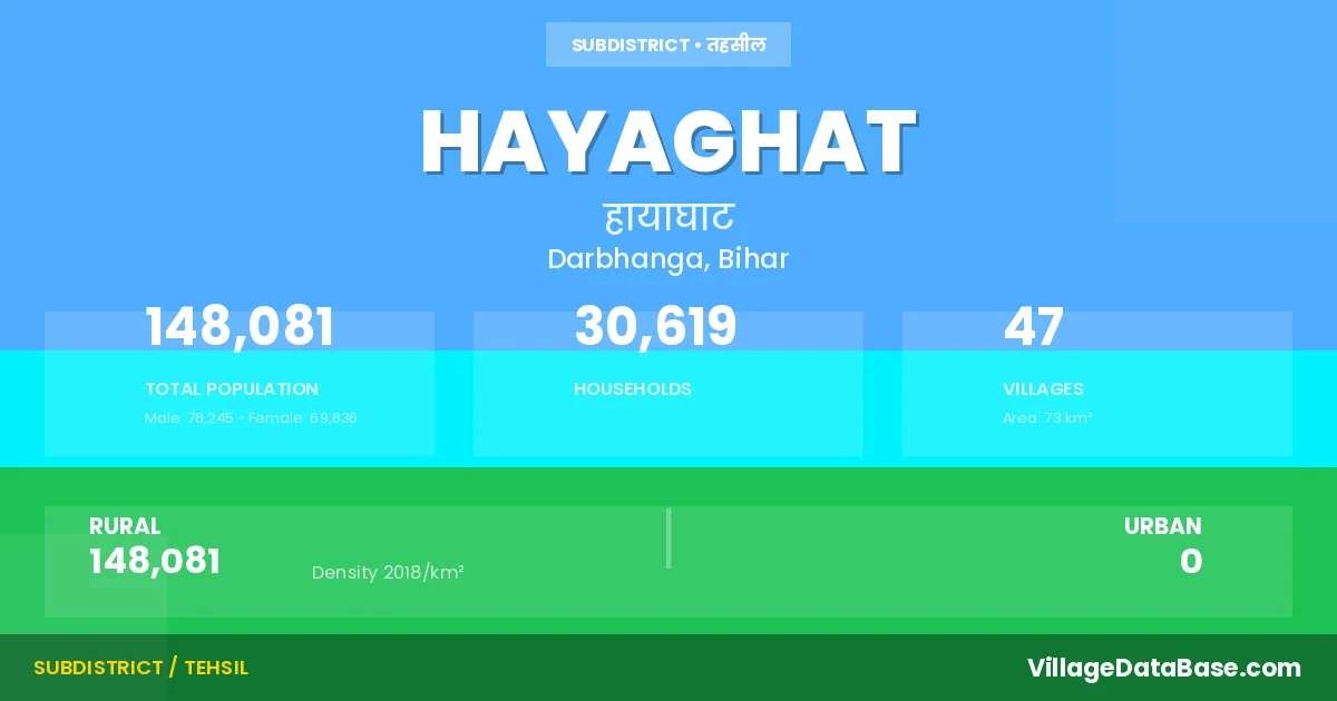
According to the 2011 census The total area of Hayaghat Subdivision is 73 km², with a population of 148081 people. The population density is 2,018 inhabitants per square kilometre, and there are approximately 30619 houses in the sub district.
Hayaghat Subdivision comprises about 47 villages. Below is a list of these villages along with information about their respective gram panchayats and the nearest town:
| # | Village Name | Gram Panchayat | Nearest Town |
|---|---|---|---|
| 1 | Akbarpur | Chandan Patti | Darbhanga (16 km) |
| 2 | Aliabad | Rasalpur | Darbhanga (15 km) |
| 3 | Anantpur | Anand Pur Sahora | Darbhanga (8 km) |
| 4 | Anar | Sidhouli | Darbhanga (10 km) |
| 5 | Anpatti Bishunpur | Sidhouli | Darbhanga (10 km) |
| 6 | Az Rakbe Bhadwar | Mirja Pur | Hayaghat |
| 7 | Bahadurpur | Hayaghat | |
| 8 | Balia | Shri Rampur | Darbhanga (30 km) |
| 9 | Bans Dih | Ghosrama | Darbhanga (20 km) |
| 10 | Berai Patti | Chandan Patti | Darbhanga (5 km) |
| 11 | Bishunpur | Mirja Pur | Darbhanga (15 km) |
| 12 | Chandana | Mirja Pur | Hayaghat |
| 13 | Chandanpatti | Chandan Patti | Darbhanga (5 km) |
| 14 | Chikni | Malhi Patti South | Darbhanga (5 km) |
| 15 | Debipur | Majhoulia | Darbhanga (10 km) |
| 16 | Dhiropatti | Anand Pur Sahora | Darbhanga (16 km) |
| 17 | Ghosrama | Ghosrama | Darbhanga (16 km) |
| 18 | Hajipur | Chandan Patti | Darbhanga (4 km) |
| 19 | Hajipur Biranpatti | Chandan Patti | Darbhanga (3 km) |
| 20 | Hawasa | Shri Rampur | Darbhanga (15 km) |
| 21 | Horil Patti | Majhoulia | Darbhanga (8 km) |
| 22 | Madhu Patti | Anand Pur Sahora | Darbhanga (11 km) |
| 23 | Mahamadpur | Darbhanga (10 km) | |
| 24 | Mahamadpur Sirnia | Malhi Patti South | Darbhanga (12 km) |
| 25 | Majhaulia Bisaipatti | Majhoulia | Darbhanga (5 km) |
| 26 | Makhanpur | Anand Pur Sahora | Darbhanga (12 km) |
| 27 | Maksudpur | Pouram | Darbhanga (16 km) |
| 28 | Malahipatti Bahadurpur | Malhi Patti North | Darbhanga (5 km) |
| 29 | Mannupur Kharra | Pouram | Darbhanga (35 km) |
| 30 | Manorathpur | Shri Rampur | Darbhanga (20 km) |
| 31 | Manorathpur Tulsi | Shri Rampur | Darbhanga (16 km) |
| 32 | Mirzapur | Mirja Pur | Darbhanga (12 km) |
| 33 | Parmanandpur | Shri Rampur | Darbhanga (12 km) |
| 34 | Parmar | Shri Rampur | Darbhanga (24 km) |
| 35 | Parsauni | Hayaghat | |
| 36 | Pator | Pator | Darbhanga (16 km) |
| 37 | Paurao | Pouram | Darbhanga (12 km) |
| 38 | Pipraulia | Chandan Patti | Darbhanga (5 km) |
| 39 | Rasulpur | Rasalpur | Darbhanga (12 km) |
| 40 | Ratanpura | Malhi Patti North | Darbhanga (3 km) |
| 41 | Singhauli | Sidhouli | Darbhanga (16 km) |
| 42 | Sirampur | Shri Rampur | Darbhanga (15 km) |
| 43 | Sirnia | Malhi Patti South | Darbhanga (12 km) |
| 44 | Siwaisinghpur | Majhoulia | Darbhanga (8 km) |
| 45 | Sobhai Patti | Sidhouli | Darbhanga (16 km) |
| 46 | Sobhnath Patti | Sidhouli | Darbhanga (16 km) |
| 47 | Usma | Malhi Patti North | Darbhanga (5 km) |
The population is distributed between urban and rural areas as follows:
| Particulars | Rural | Urban | Total |
|---|---|---|---|
| Total Population | 148081 | 0 | 148081 |
| Male Population | 78245 | 0 | 78245 |
| Female Population | 69836 | 0 | 69836 | Population Density | 2018 / km² | 2,018 / km² |
The distribution of households in the Hayaghat is:
| Rural Households | Urban Households | Total Households |
|---|---|---|
| 30619 | 0 | 30619 |
Q: What is Hayaghat?
A: Hayaghat is a town and in the Darbhanga district of the Bihar.
Q: What is the total area of Hayaghat Subdivision?
A: The total area of Hayaghat Subdivision is 73 km².
Q: What is the population of Hayaghat Subdivision according to the 2011 census?
A: According to the 2011 census, the population of Hayaghat Subdivision is 148081.
Q: What is the population density of Hayaghat Subdivision?
A: The population density of Hayaghat Subdivision is 2,018 inhabitants per square kilometre.
Q: How many houses are there in Hayaghat Subdivision?
A: There are approximately 30619 houses in Hayaghat Subdivision.
Q: How many villages are there in Hayaghat Subdivision?
A: There are about 47 villages in Hayaghat Subdivision.
Q: Which is the largest village by population in Hayaghat Subdivision?
A: The largest village by population in Hayaghat Subdivision is Sirnia, with 26767 people.
Q: Which is the smallest village by population in Hayaghat Subdivision?
A: The smallest village by population in Hayaghat Subdivision is Az Rakbe Bhadwar, with 0 people.
Q: Which is the largest village by area in Hayaghat Subdivision?
A: The largest village by area in Hayaghat Subdivision is Sirnia, with 1108 km².
Q: Which is the smallest village by area in Hayaghat Subdivision?
A: The smallest village by area in Hayaghat Subdivision is Bahadurpur, with 7 km².
Q: What is the population distribution between urban and rural areas in Hayaghat Subdivision?
A: The population distribution in Hayaghat Subdivision is entirely rural, with a total rural population of 148081.
Q: What is the male population of Hayaghat Subdivision?
A: The male population of Hayaghat Subdivision is 78245.
Q: What is the female population of Hayaghat Subdivision?
A: The female population of Hayaghat Subdivision is 69836.
Q: How is the household distribution in Hayaghat Subdivision?
A: The household distribution in Hayaghat Subdivision is entirely rural, with a total of 30619 households.
Q: How many villages in Hayaghat Subdivision have a population of less than 100?
A: There are 5 villages in Hayaghat Subdivision with a population of less than 100.
Q: How many villages in Hayaghat Subdivision have a population between 100 and 499?
A: There are 2 villages in Hayaghat Subdivision with a population between 100 and 499.
Q: How many villages in Hayaghat Subdivision have a population between 500 and 999?
A: There are 6 villages in Hayaghat Subdivision with a population between 500 and 999.
Q: How many villages in Hayaghat Subdivision have a population between 1000 and 1999?
A: There are 14 villages in Hayaghat Subdivision with a population between 1000 and 1999.
Q: How many villages in Hayaghat Subdivision have a population between 2000 and 2999?
A: There is 4 village in Hayaghat Subdivision with a population between 2000 and 2999.
Q: How many villages in Hayaghat Subdivision have a population between 3000 and 3999?
A: There is 5 village in Hayaghat Subdivision with a population between 3000 and 3999.
Q: How many villages in Hayaghat Subdivision have a population between 4000 and 4999?
A: There is 4 village in Hayaghat Subdivision with a population between 4000 and 4999.
Q: How many villages in Hayaghat Subdivision have a population of 5000 and above?
A: There is 7 village in Hayaghat Subdivision with a population of 5000 and above.
| Total Population | Villages in Sub District Of Hayaghat |
|---|---|
| Less than 100 | 5 |
| 100-499 | 2 |
| 500-999 | 6 |
| 1000-1999 | 14 |
| 2000-2999 | 4 |
| 3000-3999 | 5 |
| 4000-4999 | 4 |
| 5000 And Above | 7 |