Keotiranway: A Town and Subdivision in Darbhanga district
District → Darbhanga
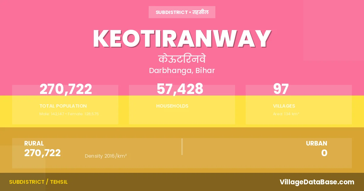
State → Bihar
Keotiranway is a town and Subdivision in the Darbhanga district of the Bihar. In India, a Subdivision is a subdivision of a district responsible for the administration and revenue collection of a specific area within the district. Subdivisions play a crucial role in the local governance structure, contributing significantly to the development and administration of their communities.
According to the 2011 census The total area of Keotiranway Subdivision is 134 km², with a population of 270722 people. The population density is 2,016 inhabitants per square kilometre, and there are approximately 57428 houses in the sub district.
Keotiranway Subdivision comprises about 97 villages. Below is a list of these villages along with information about their respective gram panchayats and the nearest town:
| # | Village Name | Gram Panchayat | Nearest Town |
|---|---|---|---|
| 1 | Agwanpatti | Sarjapur | Keotiranway |
| 2 | Andama | Nanaura | Darbhanga (17 km) |
| 3 | Asrafpur | Shekhpur Dani | Darbhanga (20 km) |
| 4 | Asraha | Asraha | Darbhanga (16 km) |
| 5 | Bansara | Bansara | Darbhanga (20 km) |
| 6 | Banwari Patti | Keoti | Darbhanga (18 km) |
| 7 | Barahi | Barahi | Darbhanga (26 km) |
| 8 | Barahi Abuara | Koila Asthan | Darbhanga (13 km) |
| 9 | Bariaul | Bariaul | Darbhanga (18 km) |
| 10 | Bazidpur | Kothia | Darbhanga (15 km) |
| 11 | Behta | Keoti | Darbhanga (20 km) |
| 12 | Belauna | Koila Asthan | Keotiranway |
| 13 | Bhagwatpur | Bansara | Darbhanga (20 km) |
| 14 | Bharathpur | Bansara | Darbhanga (20 km) |
| 15 | Bheriahi | Koila Asthan | Darbhanga (10 km) |
| 16 | Bhojpatti | Pindaruch | Darbhanga (15 km) |
| 17 | Bhokraha | Nanaura | Keotiranway |
| 18 | Bihatwara | Koila Asthan | Darbhanga (14 km) |
| 19 | Binwara | Khirma | Darbhanga (11 km) |
| 20 | Birkha | Nanaura | Darbhanga (28 km) |
| 21 | Birkhauli | Nanaura | Darbhanga (20 km) |
| 22 | Birna | Karjapatti | Darbhanga (19 km) |
| 23 | Bishunpur | Sarjapur | Darbhanga (22 km) |
| 24 | Chak Ajam | Shekhpur Dani | Darbhanga (12 km) |
| 25 | Chak Bhawani | Keoti | Darbhanga (20 km) |
| 26 | Chakka | Lahwar | Darbhanga (25 km) |
| 27 | Chamarjana Urf Dudhia | Koila Asthan | Darbhanga (20 km) |
| 28 | Chatra | Koila Asthan | Darbhanga (14 km) |
| 29 | Chhachha | Chhachha Pachadhi | Darbhanga (28 km) |
| 30 | Chhatwan | Chhatwan | Darbhanga (26 km) |
| 31 | Dalwa | Koila Asthan | Darbhanga (18 km) |
| 32 | Darma | Paigambarpur | Darbhanga (21 km) |
| 33 | Dheri Chak | Nanaura | Darbhanga (15 km) |
| 34 | Dhobgawan | Ladari | Darbhanga (22 km) |
| 35 | Dhuria | Asraha | Darbhanga (17 km) |
| 36 | Dhuria Chhaunia | Sarjapur | Keotiranway |
| 37 | Dhuria Daharia | Nanaura | Darbhanga (28 km) |
| 38 | Dighiar | Dighiyar | Darbhanga (20 km) |
| 39 | Dome | Koila Asthan | Darbhanga (15 km) |
| 40 | Ekdara | Ladari | Keotiranway |
| 41 | Gobindpur | Pindaruch | Darbhanga (15 km) |
| 42 | Gokhul | Sarjapur | Darbhanga (28 km) |
| 43 | Hajipur | Ladari | Darbhanga (12 km) |
| 44 | Hanuman Nagar | Nanaura | Darbhanga (17 km) |
| 45 | Harpur | Koila Asthan | Darbhanga (10 km) |
| 46 | Jahangirpur | Lahwar | Keotiranway |
| 47 | Jalwara | Jalwara | Darbhanga (22 km) |
| 48 | Jethiahi | Asraha | Darbhanga (16 km) |
| 49 | Jiwar | Sarjapur | Darbhanga (26 km) |
| 50 | Kaem Chak | Majhigama | Darbhanga (22 km) |
| 51 | Kaharia | Bariaul | Darbhanga (18 km) |
| 52 | Kamaldah | Bansara | Darbhanga (20 km) |
| 53 | Karjapatti | Karjapatti | Darbhanga (20 km) |
| 54 | Kasma Balbhadar | Bansara | Darbhanga (20 km) |
| 55 | Kasma Lala | Asraha | Keotiranway |
| 56 | Keoti Ranwe | Keoti | Darbhanga (20 km) |
| 57 | Kheraj Dhuria | Sarjapur | Darbhanga (28 km) |
| 58 | Kheraj Mardan Singh | Barahi | Darbhanga (20 km) |
| 59 | Khirma | Khirma | Darbhanga (10 km) |
| 60 | Kishunpur | Koila Asthan | Darbhanga (20 km) |
| 61 | Koilathan | Koila Asthan | Darbhanga (10 km) |
| 62 | Kopgarh | Bansara | Darbhanga (20 km) |
| 63 | Kothia | Kothia | Darbhanga (15 km) |
| 64 | Kothli Majhiama | Majhigama | Darbhanga (15 km) |
| 65 | Ladari | Ladari | Darbhanga (20 km) |
| 66 | Lahuar | Lahwar | Darbhanga (25 km) |
| 67 | Lalganj Urf Badh | Lalganj | Darbhanga (15 km) |
| 68 | Madhopatti Raghauli | Madho Patti | Darbhanga (22 km) |
| 69 | Mahamadpur | Majhigama | Darbhanga (18 km) |
| 70 | Maheshajan | Ladari | Darbhanga (22 km) |
| 71 | Megha | Koila Asthan | Darbhanga (10 km) |
| 72 | Milki | Majhigama | Darbhanga (18 km) |
| 73 | Mohan Math | Pindaruch | Darbhanga (15 km) |
| 74 | Mohanpur | Bansara | Darbhanga (20 km) |
| 75 | Naya Gaon | Naya Gaon East | Darbhanga (21 km) |
| 76 | Nonaura | Nanaura | Darbhanga (17 km) |
| 77 | Pacharhi | Chhachha Pachadhi | Darbhanga (22 km) |
| 78 | Pachma | Kothia | Darbhanga (15 km) |
| 79 | Paigambarpur | Paigambarpur | Darbhanga (22 km) |
| 80 | Para | Ladari | Darbhanga (14 km) |
| 81 | Pathra | Khirma | Darbhanga (9 km) |
| 82 | Pilakhwar | Lahwar | Darbhanga (25 km) |
| 83 | Pindaruch | Pindaruch | Darbhanga (15 km) |
| 84 | Radha | Karjapatti | Darbhanga (12 km) |
| 85 | Raiam | Rajaura | Darbhanga (25 km) |
| 86 | Rajaura | Rajaura | Darbhanga (25 km) |
| 87 | Rasulpur | Nanaura | Darbhanga (15 km) |
| 88 | Ratauli | Khirma | Darbhanga (12 km) |
| 89 | Sahahpur | Majhigama | Keotiranway |
| 90 | Sahpur Dih | Majhigama | Darbhanga (20 km) |
| 91 | Samaila | Chhachha Pachadhi | Keotiranway |
| 92 | Sarhwara | Shekhpur Dani | Darbhanga (20 km) |
| 93 | Sarjapur | Lahwar | Darbhanga (28 km) |
| 94 | Shekhpatti | Shekhpur Dani | Darbhanga (19 km) |
| 95 | Shekhpura Urf Dagarwara | Shekhpur Dani | Darbhanga (20 km) |
| 96 | Surat Galkar | Paigambarpur | Keotiranway |
| 97 | Tektar | Kothia | Darbhanga (20 km) |
The population is distributed between urban and rural areas as follows:
| Particulars | Rural | Urban | Total |
|---|---|---|---|
| Total Population | 270722 | 0 | 270722 |
| Male Population | 142147 | 0 | 142147 |
| Female Population | 128575 | 0 | 128575 | Population Density | 2016 / km² | 2,016 / km² |
The distribution of households in the Keotiranway is:
| Rural Households | Urban Households | Total Households |
|---|---|---|
| 57428 | 0 | 57428 |
Q: What is Keotiranway?
A: Keotiranway is a town and in the Darbhanga district of the Bihar.
Q: What is the total area of Keotiranway Subdivision?
A: The total area of Keotiranway Subdivision is 134 km².
Q: What is the population of Keotiranway Subdivision according to the 2011 census?
A: According to the 2011 census, the population of Keotiranway Subdivision is 270722.
Q: What is the population density of Keotiranway Subdivision?
A: The population density of Keotiranway Subdivision is 2,016 inhabitants per square kilometre.
Q: How many houses are there in Keotiranway Subdivision?
A: There are approximately 57428 houses in Keotiranway Subdivision.
Q: How many villages are there in Keotiranway Subdivision?
A: There are about 97 villages in Keotiranway Subdivision.
Q: Which is the largest village by population in Keotiranway Subdivision?
A: The largest village by population in Keotiranway Subdivision is Naya Gaon, with 16690 people.
Q: Which is the smallest village by population in Keotiranway Subdivision?
A: The smallest village by population in Keotiranway Subdivision is Agwanpatti, with 0 people.
Q: Which is the largest village by area in Keotiranway Subdivision?
A: The largest village by area in Keotiranway Subdivision is Naya Gaon, with 940 km².
Q: Which is the smallest village by area in Keotiranway Subdivision?
A: The smallest village by area in Keotiranway Subdivision is Kishunpur, with 4 km².
Q: What is the population distribution between urban and rural areas in Keotiranway Subdivision?
A: The population distribution in Keotiranway Subdivision is entirely rural, with a total rural population of 270722.
Q: What is the male population of Keotiranway Subdivision?
A: The male population of Keotiranway Subdivision is 142147.
Q: What is the female population of Keotiranway Subdivision?
A: The female population of Keotiranway Subdivision is 128575.
Q: How is the household distribution in Keotiranway Subdivision?
A: The household distribution in Keotiranway Subdivision is entirely rural, with a total of 57428 households.
Q: How many villages in Keotiranway Subdivision have a population of less than 100?
A: There are 10 villages in Keotiranway Subdivision with a population of less than 100.
Q: How many villages in Keotiranway Subdivision have a population between 100 and 499?
A: There are 10 villages in Keotiranway Subdivision with a population between 100 and 499.
Q: How many villages in Keotiranway Subdivision have a population between 500 and 999?
A: There are 10 villages in Keotiranway Subdivision with a population between 500 and 999.
Q: How many villages in Keotiranway Subdivision have a population between 1000 and 1999?
A: There are 26 villages in Keotiranway Subdivision with a population between 1000 and 1999.
Q: How many villages in Keotiranway Subdivision have a population between 2000 and 2999?
A: There is 11 village in Keotiranway Subdivision with a population between 2000 and 2999.
Q: How many villages in Keotiranway Subdivision have a population between 3000 and 3999?
A: There is 9 village in Keotiranway Subdivision with a population between 3000 and 3999.
Q: How many villages in Keotiranway Subdivision have a population between 4000 and 4999?
A: There is 7 village in Keotiranway Subdivision with a population between 4000 and 4999.
Q: How many villages in Keotiranway Subdivision have a population of 5000 and above?
A: There is 14 village in Keotiranway Subdivision with a population of 5000 and above.
| Total Population | Villages in Sub District Of Keotiranway |
|---|---|
| Less than 100 | 10 |
| 100-499 | 10 |
| 500-999 | 10 |
| 1000-1999 | 26 |
| 2000-2999 | 11 |
| 3000-3999 | 9 |
| 4000-4999 | 7 |
| 5000 And Above | 14 |