District → Gaya
State → Bihar
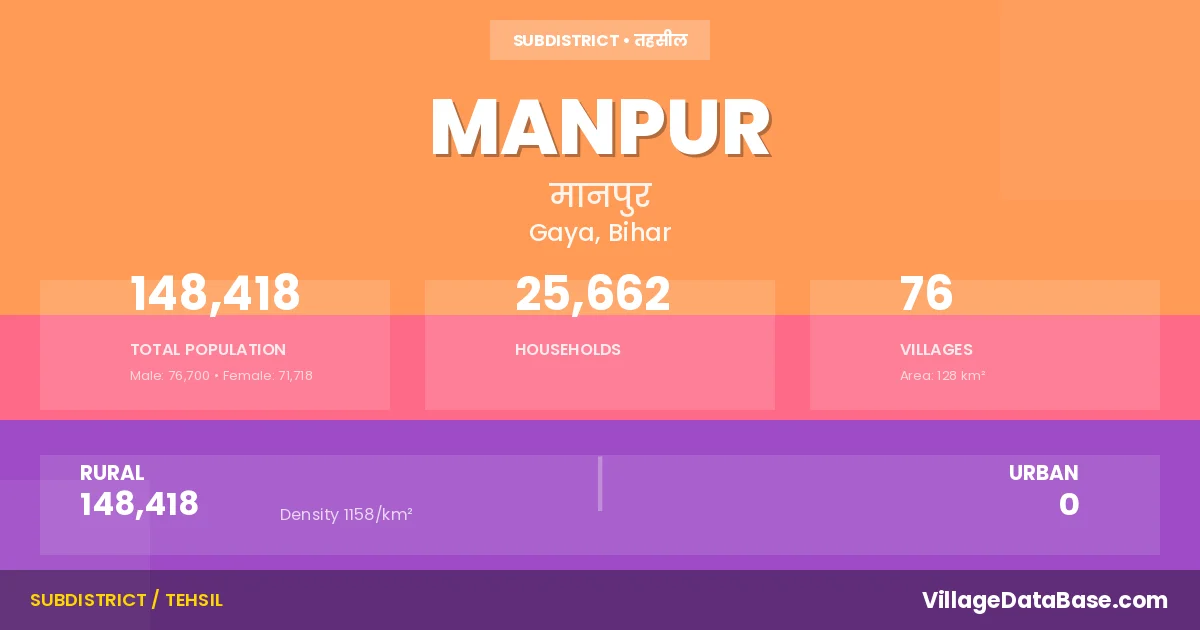
Manpur is a town and Subdivision in the Gaya district of the Bihar. In India, a Subdivision is a subdivision of a district responsible for the administration and revenue collection of a specific area within the district. Subdivisions play a crucial role in the local governance structure, contributing significantly to the development and administration of their communities.
According to the 2011 census The total area of Manpur Subdivision is 128 km², with a population of 148418 people. The population density is 1,158 inhabitants per square kilometre, and there are approximately 25662 houses in the sub district.
Manpur Subdivision comprises about 76 villages. Below is a list of these villages along with information about their respective gram panchayats and the nearest town:
| # | Village Name | Gram Panchayat | Nearest Town |
|---|---|---|---|
| 1 | Abgila | Bara Gandhar | Gaya (4 km) |
| 2 | Alawal Chak | Bhore | Gaya (13 km) |
| 3 | Amari | Sohai Pur | Gaya (15 km) |
| 4 | Amra | Sohai Pur | Gaya (15 km) |
| 5 | Badahpur | Bhore | Gaya (16 km) |
| 6 | Badra | Bhore | Gaya (18 km) |
| 7 | Bagahi Kalan | Sohai Pur | Gaya (15 km) |
| 8 | Baijal Tetariya | Lakhan Pur | Gaya (10 km) |
| 9 | Bandhuwa | Sohai Pur | Gaya (8 km) |
| 10 | Bara | Gere | Gaya (11 km) |
| 11 | Belhanta | Kaiya | Gaya (12 km) |
| 12 | Berewa | Sonaut | Gaya (8 km) |
| 13 | Bhadeja | Bhadeja | Gaya (6 km) |
| 14 | Bhadeji | Bhadeja | Gaya (6 km) |
| 15 | Bheriya | Nanauk | Gaya (18 km) |
| 16 | Bhore | Bhore | Gaya (10 km) |
| 17 | Bhualpur | Sonaut | Gaya (9 km) |
| 18 | Bhusanda | Nauranga | Gaya (4 km) |
| 19 | Biju Bigha | Nanauk | Gaya (12 km) |
| 20 | Bisar | Kaiya | Gaya (14 km) |
| 21 | Burhgere | Lakhan Pur | Gaya (8 km) |
| 22 | Burhi | Bhore | Gaya (18 km) |
| 23 | Chiraila | Kaiya | Gaya (15 km) |
| 24 | Delha | Nanauk | Gaya (12 km) |
| 25 | Dohari | Sonaut | Gaya (10 km) |
| 26 | Dudhaila | Sonaut | Gaya (12 km) |
| 27 | Gandhar | Bara Gandhar | Gaya (8 km) |
| 28 | Gangti | Shadi Pur | Gaya (6 km) |
| 29 | Ganjas | Sohai Pur | Gaya (13 km) |
| 30 | Gaura | Lakhan Pur | Gaya (8 km) |
| 31 | Gere | Gere | Gaya (5 km) |
| 32 | Goga | Kaiya | Gaya (7 km) |
| 33 | Harli | Lakhan Pur | Gaya (15 km) |
| 34 | Hunrrahi | Usari | Gaya (10 km) |
| 35 | Inguna | Bhadeja | Gaya (6 km) |
| 36 | Jamuanwan | Sohai Pur | Gaya (17 km) |
| 37 | Kaiya | Kaiya | Gaya (12 km) |
| 38 | Kamalpur | Bara Gandhar | Gaya (6 km) |
| 39 | Kemun Chak | Usari | Gaya (13 km) |
| 40 | Kharhari | Kaiya | Gaya (13 km) |
| 41 | Khedarpura | Nanauk | Gaya (12 km) |
| 42 | Kukiasin | Shadi Pur | Gaya (10 km) |
| 43 | Lakhanpur | Lakhan Pur | Gaya (8 km) |
| 44 | Lodipur | Gere | Gaya (8 km) |
| 45 | Madarpur | Nanauk | Gaya (12 km) |
| 46 | Mahuar | Nanauk | Gaya (10 km) |
| 47 | Mahuar Kalan | Nanauk | Gaya (15 km) |
| 48 | Majhauli | Bhadeja | Gaya (5 km) |
| 49 | Masautha Kalan | Lakhan Pur | Gaya (10 km) |
| 50 | Masautha Khurd | Lakhan Pur | Gaya (12 km) |
| 51 | Mast Alipur | Nauranga | Gaya (3 km) |
| 52 | Meharban Chak | Sohai Pur | Gaya (13 km) |
| 53 | Mirzapur | Gere | Gaya (6 km) |
| 54 | Nanauk | Nanauk | Gaya (15 km) |
| 55 | Nanhak Chak | Gere | Gaya (12 km) |
| 56 | Naroghat | Sonaut | Gaya (10 km) |
| 57 | Nasirpur | Bhore | Gaya (18 km) |
| 58 | Naudhariya | Usari | Gaya (18 km) |
| 59 | Nauranga | Nauranga | Gaya (4 km) |
| 60 | Nawada | Nanauk | Gaya (10 km) |
| 61 | Nima | Bhore | Gaya (15 km) |
| 62 | Pachamba | Bhore | Gaya (18 km) |
| 63 | Panda Bigha | Usari | Gaya (10 km) |
| 64 | Paroriya | Sohai Pur | Gaya (13 km) |
| 65 | Pathalghatta | Shadi Pur | Gaya (8 km) |
| 66 | Rasalpur | Lakhan Pur | Gaya (6 km) |
| 67 | Rasuna | Gere | Gaya (8 km) |
| 68 | Sadipur | Shadi Pur | Gaya (8 km) |
| 69 | Sikahar | Bara Gandhar | Gaya (6 km) |
| 70 | Sohaipur | Sohai Pur | Gaya (11 km) |
| 71 | Sonaut | Sonaut | Gaya (10 km) |
| 72 | Sondhi | Shadi Pur | Gaya (12 km) |
| 73 | Surheri | Bhadeja | Gaya (6 km) |
| 74 | Tapsi | Bhore | Gaya (10 km) |
| 75 | Telar | Bhore | Manpur |
| 76 | Usri | Usari | Gaya (9 km) |
The population is distributed between urban and rural areas as follows:
| Particulars | Rural | Urban | Total |
|---|---|---|---|
| Total Population | 148418 | 0 | 148418 |
| Male Population | 76700 | 0 | 76700 |
| Female Population | 71718 | 0 | 71718 | Population Density | 1158 / km² | 1,158 / km² |
The distribution of households in the Manpur is:
| Rural Households | Urban Households | Total Households |
|---|---|---|
| 25662 | 0 | 25662 |
Q: What is Manpur?
A: Manpur is a town and in the Gaya district of the Bihar.
Q: What is the total area of Manpur Subdivision?
A: The total area of Manpur Subdivision is 128 km².
Q: What is the population of Manpur Subdivision according to the 2011 census?
A: According to the 2011 census, the population of Manpur Subdivision is 148418.
Q: What is the population density of Manpur Subdivision?
A: The population density of Manpur Subdivision is 1,158 inhabitants per square kilometre.
Q: How many houses are there in Manpur Subdivision?
A: There are approximately 25662 houses in Manpur Subdivision.
Q: How many villages are there in Manpur Subdivision?
A: There are about 76 villages in Manpur Subdivision.
Q: Which is the largest village by population in Manpur Subdivision?
A: The largest village by population in Manpur Subdivision is Nauranga, with 11858 people.
Q: Which is the smallest village by population in Manpur Subdivision?
A: The smallest village by population in Manpur Subdivision is Telar, with 0 people.
Q: Which is the largest village by area in Manpur Subdivision?
A: The largest village by area in Manpur Subdivision is Gere, with 527 km².
Q: Which is the smallest village by area in Manpur Subdivision?
A: The smallest village by area in Manpur Subdivision is Kemun Chak, with 31 km².
Q: What is the population distribution between urban and rural areas in Manpur Subdivision?
A: The population distribution in Manpur Subdivision is entirely rural, with a total rural population of 148418.
Q: What is the male population of Manpur Subdivision?
A: The male population of Manpur Subdivision is 76700.
Q: What is the female population of Manpur Subdivision?
A: The female population of Manpur Subdivision is 71718.
Q: How is the household distribution in Manpur Subdivision?
A: The household distribution in Manpur Subdivision is entirely rural, with a total of 25662 households.
Q: How many villages in Manpur Subdivision have a population of less than 100?
A: There are 2 villages in Manpur Subdivision with a population of less than 100.
Q: How many villages in Manpur Subdivision have a population between 100 and 499?
A: There are 7 villages in Manpur Subdivision with a population between 100 and 499.
Q: How many villages in Manpur Subdivision have a population between 500 and 999?
A: There are 22 villages in Manpur Subdivision with a population between 500 and 999.
Q: How many villages in Manpur Subdivision have a population between 1000 and 1999?
A: There are 17 villages in Manpur Subdivision with a population between 1000 and 1999.
Q: How many villages in Manpur Subdivision have a population between 2000 and 2999?
A: There is 15 village in Manpur Subdivision with a population between 2000 and 2999.
Q: How many villages in Manpur Subdivision have a population between 3000 and 3999?
A: There is 3 village in Manpur Subdivision with a population between 3000 and 3999.
Q: How many villages in Manpur Subdivision have a population between 4000 and 4999?
A: There is 7 village in Manpur Subdivision with a population between 4000 and 4999.
Q: How many villages in Manpur Subdivision have a population of 5000 and above?
A: There is 3 village in Manpur Subdivision with a population of 5000 and above.
| Total Population | Villages in Sub District Of Manpur |
|---|---|
| Less than 100 | 2 |
| 100-499 | 7 |
| 500-999 | 22 |
| 1000-1999 | 17 |
| 2000-2999 | 15 |
| 3000-3999 | 3 |
| 4000-4999 | 7 |
| 5000 And Above | 3 |