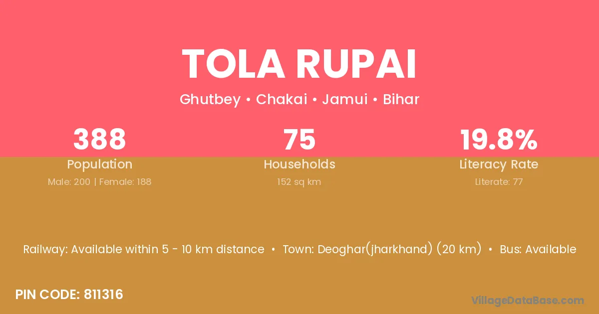
Tola Rupai village is located in the Chakai Subdivision of the Jamui district in Bihar .
Block / Subdivision → Chakai
District → Jamui
State → Bihar
According to Census 2011 information, the village code of Tola Rupai village is 811316.
Tola Rupai village has a total population of 388 people, of which 200 are males and 188 are females.
The literacy rate of Tola Rupai village is 19.85%. Male literacy stands at 29.50% and female literacy at 9.57%.
There are approximately 75 households in Tola Rupai village.
Deoghar(jharkhand) (20 km) is the nearest town to Tola Rupai village for major economic activities and is located approximately 20 km away.
The population of Tola Rupai village is distributed between literate and illiterate residents as follows:
| Particulars | Male | Female | Total |
|---|---|---|---|
| Literate | 59 | 18 | 77 |
| Illiterate | 141 | 170 | 311 |
| Total | 200 | 188 | 388 |
Source: Census 2011
| Village | District |
|---|---|
| Tola Ambakol | Jamui |
| Tola Belatanr | Jamui |
| Tola Belatanr | Jamui |
| Tola Belatanr | Jamui |
| Tola Belatanr | Jamui |
| Tola Bhaluari | Jamui |
| Tola Dhanwegadi | Jamui |
| Tola Gadarjor | Jamui |
| Tola Ghatiani | Jamui |
| Tola Ghormara | Banka |
| Tola Ghormara | Jamui |
| Tola Ghormara | Jamui |
| Tola Ghutwe | Jamui |
| Tola Ghutwe | Jamui |
| Tola Kabilaspur | Jamui |
| Tola Phuta | Jamui |
| Tola Sonaia | Jamui |
No reviews yet. Be the first to review this village!
Available within 5 - 10 km distance
Available within 5 - 10 km distance
Available within 10+ km distance