Durgawati: A Town and Subdivision in Kaimur district
District → Kaimur
State → Bihar
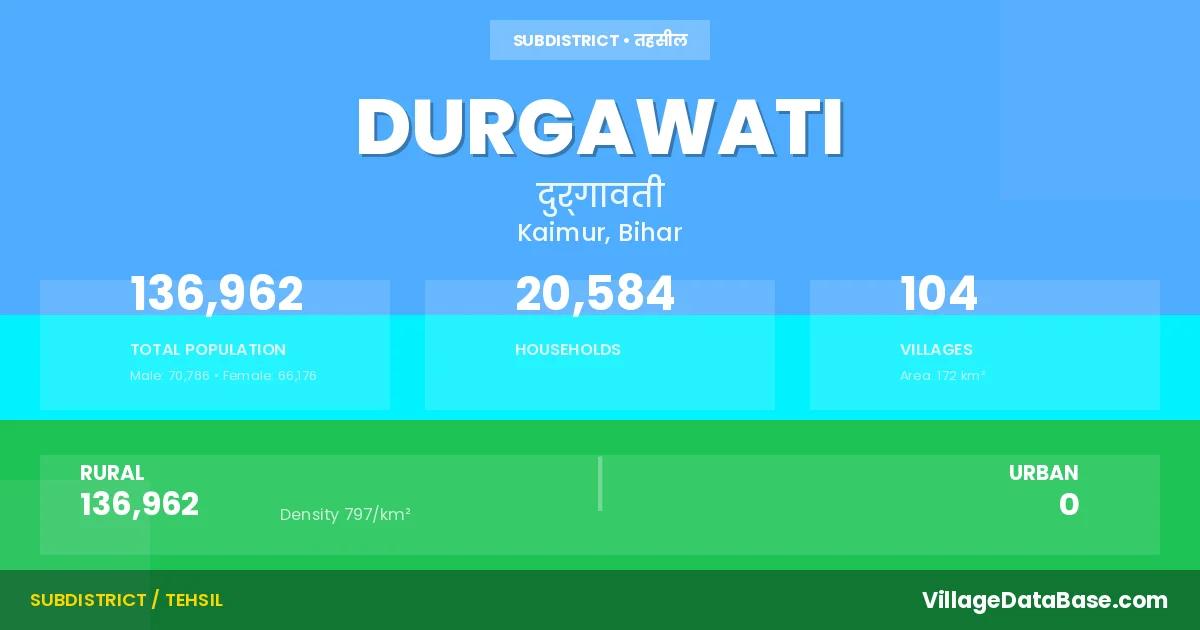
Durgawati is a town and Subdivision in the Kaimur district of the Bihar. In India, a Subdivision is a subdivision of a district responsible for the administration and revenue collection of a specific area within the district. Subdivisions play a crucial role in the local governance structure, contributing significantly to the development and administration of their communities.
According to the 2011 census The total area of Durgawati Subdivision is 172 km², with a population of 136962 people. The population density is 797 inhabitants per square kilometre, and there are approximately 20584 houses in the sub district.
Durgawati Subdivision comprises about 104 villages. Below is a list of these villages along with information about their respective gram panchayats and the nearest town:
| # | Village Name | Gram Panchayat | Nearest Town |
|---|---|---|---|
| 1 | Amirti | Kharsara | Bhabua (36 km) |
| 2 | Anantpur | Kharsara | Durgawati |
| 3 | Anwarhiya | Awahriya | Bhabua (32 km) |
| 4 | Arazi Kalyanpur | Kalyanpur | Durgawati |
| 5 | Ashoga | Awahriya | Bhabua (35 km) |
| 6 | Asurha | Kalyanpur | Bhabua (38 km) |
| 7 | Ataria | Kalyanpur | Bhabua (38 km) |
| 8 | Baruri | Dharhar | Bhabua (38 km) |
| 9 | Basawanpur | Dharhar | Bhabua (36 km) |
| 10 | Belhari | Jewari | Durgawati |
| 11 | Bhadaini | Chhaw | Bhabua (39 km) |
| 12 | Bhagwanpur | Dharhar | Bhabua (37 km) |
| 13 | Bhanpur | Dharhar | Bhabua (45 km) |
| 14 | Bheria | Chhaw | Bhabua (47 km) |
| 15 | Bichhiya | Dumari | Bhabua (36 km) |
| 16 | Bilkhori | Dharhar | Bhabua (38 km) |
| 17 | Chahria | Chehariya | Bhabua (34 km) |
| 18 | Chhajupur | Khajura | Bhabua (40 km) |
| 19 | Chhata | Jewari | Bhabua (42 km) |
| 20 | Chhawan | Chhaw | Bhabua (46 km) |
| 21 | Chipali | Dharhar | Bhabua (37 km) |
| 22 | Chogara | Awahriya | Bhabua (34 km) |
| 23 | Dahiyawan | Sawath | Bhabua (31 km) |
| 24 | Dahla | Sawath | Bhabua (31 km) |
| 25 | Dakaha | Kalyanpur | Durgawati |
| 26 | Darauli | Sawath | Bhabua (31 km) |
| 27 | Dhan Saray | Dharhar | Bhabua (38 km) |
| 28 | Dhanichha | Kharsara | Bhabua (36 km) |
| 29 | Dhanipur | Awahriya | Bhabua (36 km) |
| 30 | Dharahra | Chehariya | Durgawati |
| 31 | Dharhar | Dharhar | Bhabua (45 km) |
| 32 | Dharhara | Chhaw | Bhabua (34 km) |
| 33 | Dirkhili | Karnpura | Bhabua (32 km) |
| 34 | Dumri | Dumari | Bhabua (37 km) |
| 35 | Dusaunti | Kharsara | Bhabua (36 km) |
| 36 | Firozpur | Kalyanpur | Bhabua (36 km) |
| 37 | Garhwa | Chehariya | Bhabua (46 km) |
| 38 | Ghinhu Patti | Masaudha | Bhabua (35 km) |
| 39 | Gimhiyan | Kalyanpur | Bhabua (33 km) |
| 40 | Gorar | Khamidaura | Bhabua (37 km) |
| 41 | Gosaisipur | Khamidaura | Bhabua (38 km) |
| 42 | Harballabhpur | Chhaw | Bhabua (50 km) |
| 43 | Harpur Pokhar | Dharhar | Durgawati |
| 44 | Isari | Khamidaura | Bhabua (37 km) |
| 45 | Ishipur | Chhaw | Bhabua (39 km) |
| 46 | Itahi | Chehariya | Bhabua (35 km) |
| 47 | Jamurni | Khajura | Bhabua (45 km) |
| 48 | Janarjanpur | Awahriya | Bhabua (33 km) |
| 49 | Jevari | Jewari | Bhabua (38 km) |
| 50 | Kabilaspur | Dumari | Bhabua (38 km) |
| 51 | Kalhnuan | Chehariya | Bhabua (36 km) |
| 52 | Kalyanpur | Kalyanpur | Bhabua (38 km) |
| 53 | Kanhpur | Dharhar | Bhabua (40 km) |
| 54 | Karanpura | Karnpura | Bhabua (32 km) |
| 55 | Karari | Jewari | Bhabua (45 km) |
| 56 | Karmi | Chehariya | Durgawati |
| 57 | Kasthar | Kalyanpur | Bhabua (37 km) |
| 58 | Kasthari | Chehariya | Bhabua (35 km) |
| 59 | Keshopur | Dharhar | Bhabua (36 km) |
| 60 | Khajura | Khajura | Bhabua (38 km) |
| 61 | Khajura Arazi | Dharhar | Durgawati |
| 62 | Khamdaura | Khamidaura | Bhabua (38 km) |
| 63 | Kharkholi | Chhaw | Bhabua (35 km) |
| 64 | Kharsara | Kharsara | Bhabua (37 km) |
| 65 | Kirpalpur | Kalyanpur | Bhabua (33 km) |
| 66 | Kotsa | Kharsara | Bhabua (36 km) |
| 67 | Kulharia | Khajura | Bhabua (37 km) |
| 68 | Kurari | Dharhar | Bhabua (44 km) |
| 69 | Kusharia | Khamidaura | Bhabua (40 km) |
| 70 | Lain | Sawath | Durgawati |
| 71 | Larma | Khajura | Bhabua (40 km) |
| 72 | Machhanhata | Chhaw | Bhabua (37 km) |
| 73 | Machkhia | Awahriya | Bhabua (33 km) |
| 74 | Madanpura | Jewari | Durgawati |
| 75 | Madhopur | Khamidaura | Bhabua (36 km) |
| 76 | Madhura | Chhaw | Bhabua (35 km) |
| 77 | Manikpur Doghara | Awahriya | Bhabua (34 km) |
| 78 | Manipur | Chhaw | Bhabua (34 km) |
| 79 | Manoharpur | Khamidaura | Bhabua (35 km) |
| 80 | Mansurpur | Kalyanpur | Bhabua (34 km) |
| 81 | Masaurha | Masaudha | Bhabua (46 km) |
| 82 | Misirpura | Kalyanpur | Bhabua (42 km) |
| 83 | Narsingha | Chehariya | Durgawati |
| 84 | Niazpur | Dharhar | Bhabua (37 km) |
| 85 | Nuawan | Masaudha | Bhabua (39 km) |
| 86 | Pachilakhi | Dumari | Bhabua (59 km) |
| 87 | Panrepur | Awahriya | Durgawati |
| 88 | Pipari | Dharhar | Bhabua (46 km) |
| 89 | Pokhra | Chhaw | Durgawati |
| 90 | Raghunathpur | Chhaw | Bhabua (40 km) |
| 91 | Rohua | Khamidaura | Bhabua (46 km) |
| 92 | Ruia | Chhaw | Bhabua (34 km) |
| 93 | Sakhelipur | Dharhar | Bhabua (38 km) |
| 94 | Sarangpur | Awahriya | Bhabua (31 km) |
| 95 | Sariawan | Khamidaura | Bhabua (39 km) |
| 96 | Sawath | Sawath | Bhabua (32 km) |
| 97 | Serwan | Kalyanpur | Durgawati |
| 98 | Shahpur | Karnpura | Durgawati |
| 99 | Shohpur | Chhaw | Bhabua (50 km) |
| 100 | Shudhia | Chhaw | Bhabua (37 km) |
| 101 | Sonawan | Awahriya | Bhabua (32 km) |
| 102 | Tiari | Kalyanpur | Bhabua (36 km) |
| 103 | Tola Gopinathpur | Kalyanpur | Bhabua (34 km) |
| 104 | Udhpura | Chehariya | Bhabua (33 km) |
The population is distributed between urban and rural areas as follows:
| Particulars | Rural | Urban | Total |
|---|---|---|---|
| Total Population | 136962 | 0 | 136962 |
| Male Population | 70786 | 0 | 70786 |
| Female Population | 66176 | 0 | 66176 | Population Density | 797 / km² | 797 / km² |
The distribution of households in the Durgawati is:
| Rural Households | Urban Households | Total Households |
|---|---|---|
| 20584 | 0 | 20584 |
Q: What is Durgawati?
A: Durgawati is a town and in the Kaimur district of the Bihar.
Q: What is the total area of Durgawati Subdivision?
A: The total area of Durgawati Subdivision is 172 km².
Q: What is the population of Durgawati Subdivision according to the 2011 census?
A: According to the 2011 census, the population of Durgawati Subdivision is 136962.
Q: What is the population density of Durgawati Subdivision?
A: The population density of Durgawati Subdivision is 797 inhabitants per square kilometre.
Q: How many houses are there in Durgawati Subdivision?
A: There are approximately 20584 houses in Durgawati Subdivision.
Q: How many villages are there in Durgawati Subdivision?
A: There are about 104 villages in Durgawati Subdivision.
Q: Which is the largest village by population in Durgawati Subdivision?
A: The largest village by population in Durgawati Subdivision is Khajura, with 6061 people.
Q: Which is the smallest village by population in Durgawati Subdivision?
A: The smallest village by population in Durgawati Subdivision is Anantpur, with 0 people.
Q: Which is the largest village by area in Durgawati Subdivision?
A: The largest village by area in Durgawati Subdivision is Masaurha, with 712 km².
Q: Which is the smallest village by area in Durgawati Subdivision?
A: The smallest village by area in Durgawati Subdivision is Chahria, with 0 km².
Q: What is the population distribution between urban and rural areas in Durgawati Subdivision?
A: The population distribution in Durgawati Subdivision is entirely rural, with a total rural population of 136962.
Q: What is the male population of Durgawati Subdivision?
A: The male population of Durgawati Subdivision is 70786.
Q: What is the female population of Durgawati Subdivision?
A: The female population of Durgawati Subdivision is 66176.
Q: How is the household distribution in Durgawati Subdivision?
A: The household distribution in Durgawati Subdivision is entirely rural, with a total of 20584 households.
Q: How many villages in Durgawati Subdivision have a population of less than 100?
A: There are 19 villages in Durgawati Subdivision with a population of less than 100.
Q: How many villages in Durgawati Subdivision have a population between 100 and 499?
A: There are 18 villages in Durgawati Subdivision with a population between 100 and 499.
Q: How many villages in Durgawati Subdivision have a population between 500 and 999?
A: There are 18 villages in Durgawati Subdivision with a population between 500 and 999.
Q: How many villages in Durgawati Subdivision have a population between 1000 and 1999?
A: There are 26 villages in Durgawati Subdivision with a population between 1000 and 1999.
Q: How many villages in Durgawati Subdivision have a population between 2000 and 2999?
A: There is 9 village in Durgawati Subdivision with a population between 2000 and 2999.
Q: How many villages in Durgawati Subdivision have a population between 3000 and 3999?
A: There is 8 village in Durgawati Subdivision with a population between 3000 and 3999.
Q: How many villages in Durgawati Subdivision have a population between 4000 and 4999?
A: There is 2 village in Durgawati Subdivision with a population between 4000 and 4999.
Q: How many villages in Durgawati Subdivision have a population of 5000 and above?
A: There is 4 village in Durgawati Subdivision with a population of 5000 and above.
| Total Population | Villages in Sub District Of Durgawati |
|---|---|
| Less than 100 | 19 |
| 100-499 | 18 |
| 500-999 | 18 |
| 1000-1999 | 26 |
| 2000-2999 | 9 |
| 3000-3999 | 8 |
| 4000-4999 | 2 |
| 5000 And Above | 4 |