Gwalpara: A Town and Subdivision in Madhepura district
District → Madhepura
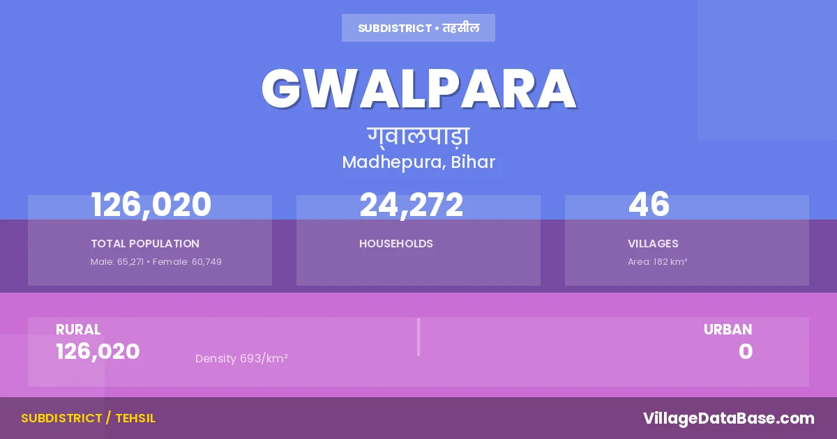
State → Bihar
Gwalpara is a town and Subdivision in the Madhepura district of the Bihar. In India, a Subdivision is a subdivision of a district responsible for the administration and revenue collection of a specific area within the district. Subdivisions play a crucial role in the local governance structure, contributing significantly to the development and administration of their communities.
According to the 2011 census The total area of Gwalpara Subdivision is 182 km², with a population of 126020 people. The population density is 693 inhabitants per square kilometre, and there are approximately 24272 houses in the sub district.
Gwalpara Subdivision comprises about 46 villages. Below is a list of these villages along with information about their respective gram panchayats and the nearest town:
| # | Village Name | Gram Panchayat | Nearest Town |
|---|---|---|---|
| 1 | Amauja | Pirnagar | Madhepura (27 km) |
| 2 | Arazi Sukhasan | Sukhasan | Madhepura (23 km) |
| 3 | Babhangawan | Sukhasan | Madhepura (23 km) |
| 4 | Bhaluahi | Jhalari | Madhepura (25 km) |
| 5 | Bhaluahi Arazi | Jhalari | Madhepura (25 km) |
| 6 | Birgaon | Birgawn Chatara | Madhepura (34 km) |
| 7 | Bishunpur Amuana | Khokasi | Madhepura (32 km) |
| 8 | Bishunpur Arar | Reshana | Madhepura (17 km) |
| 9 | Bishunpur Kantahi | Tema Bhela | Madhepura (36 km) |
| 10 | Biswari | Biswari | Madhepura (25 km) |
| 11 | Chakla Gopal Jha | Tema Bhela | Madhepura (32 km) |
| 12 | Chakla Pitambar Misra | Sukhasan | Madhepura (25 km) |
| 13 | Chatra Badh | Birgawn Chatara | Madhepura (30 km) |
| 14 | Chatra Chak | Birgawn Chatara | Madhepura (24 km) |
| 15 | Depura | Reshana | Madhepura (18 km) |
| 16 | Fakirna | Sarauni | Madhepura (27 km) |
| 17 | Goalpara | Birgawn Chatara | Madhepura (23 km) |
| 18 | Jagatpur | Tema Bhela | Madhepura (32 km) |
| 19 | Jhajhari | Biswari | Madhepura (26 km) |
| 20 | Jhalari | Jhalari | Madhepura (25 km) |
| 21 | Jhitkia | Jhitakia Kaloutaha | Madhepura (22 km) |
| 22 | Jhitkia Hadi | Jhitakia Kaloutaha | Madhepura (25 km) |
| 23 | Jotmanohar | Biswari | Madhepura (27 km) |
| 24 | Kalotaha | Jhitakia Kaloutaha | Madhepura (25 km) |
| 25 | Kalyanpatti | Tema Bhela | Madhepura (30 km) |
| 26 | Khokhsi Saranpur | Khokasi | Madhepura (31 km) |
| 27 | Khoksi Saranpur Milik | Khokasi | Madhepura (32 km) |
| 28 | Lohar | Gwalpara | Madhepura (24 km) |
| 29 | Mahrajganj | Tema Bhela | Madhepura (26 km) |
| 30 | Mahrajganj Urf Pahifatehpur | Sukhasan | Madhepura (31 km) |
| 31 | Mohammadpur | Pirnagar | Madhepura (27 km) |
| 32 | Pandukia Milik | Tema Bhela | Madhepura (32 km) |
| 33 | Parsaha | Tema Bhela | Madhepura (27 km) |
| 34 | Parsi | Jhitakia Kaloutaha | Madhepura (25 km) |
| 35 | Pirnagar | Pirnagar | Madhepura (27 km) |
| 36 | Rajpur Sarsandi | Biswari | Madhepura (25 km) |
| 37 | Rakhia Patti | Sukhasan | Madhepura (29 km) |
| 38 | Rasna | Reshana | Madhepura (16 km) |
| 39 | Sarauni Kalan | Sarauni | Madhepura (28 km) |
| 40 | Shahpur Chaumukh | Shahpur | Madhepura (22 km) |
| 41 | Shyam | Pirnagar | Madhepura (29 km) |
| 42 | Sindwari | Shahpur | Madhepura (26 km) |
| 43 | Siswapatti | Sukhasan | Madhepura (28 km) |
| 44 | Sukhasan | Sukhasan | Madhepura (22 km) |
| 45 | Tema | Tema Bhela | Madhepura (24 km) |
| 46 | Temabhela | Tema Bhela | Madhepura (33 km) |
The population is distributed between urban and rural areas as follows:
| Particulars | Rural | Urban | Total |
|---|---|---|---|
| Total Population | 126020 | 0 | 126020 |
| Male Population | 65271 | 0 | 65271 |
| Female Population | 60749 | 0 | 60749 | Population Density | 693 / km² | 693 / km² |
The distribution of households in the Gwalpara is:
| Rural Households | Urban Households | Total Households |
|---|---|---|
| 24272 | 0 | 24272 |
Q: What is Gwalpara?
A: Gwalpara is a town and in the Madhepura district of the Bihar.
Q: What is the total area of Gwalpara Subdivision?
A: The total area of Gwalpara Subdivision is 182 km².
Q: What is the population of Gwalpara Subdivision according to the 2011 census?
A: According to the 2011 census, the population of Gwalpara Subdivision is 126020.
Q: What is the population density of Gwalpara Subdivision?
A: The population density of Gwalpara Subdivision is 693 inhabitants per square kilometre.
Q: How many houses are there in Gwalpara Subdivision?
A: There are approximately 24272 houses in Gwalpara Subdivision.
Q: How many villages are there in Gwalpara Subdivision?
A: There are about 46 villages in Gwalpara Subdivision.
Q: Which is the largest village by population in Gwalpara Subdivision?
A: The largest village by population in Gwalpara Subdivision is Sarauni Kalan, with 11596 people.
Q: Which is the smallest village by population in Gwalpara Subdivision?
A: The smallest village by population in Gwalpara Subdivision is Arazi Sukhasan, with 146 people.
Q: Which is the largest village by area in Gwalpara Subdivision?
A: The largest village by area in Gwalpara Subdivision is Shahpur Chaumukh, with 890 km².
Q: Which is the smallest village by area in Gwalpara Subdivision?
A: The smallest village by area in Gwalpara Subdivision is Arazi Sukhasan, with 17 km².
Q: What is the population distribution between urban and rural areas in Gwalpara Subdivision?
A: The population distribution in Gwalpara Subdivision is entirely rural, with a total rural population of 126020.
Q: What is the male population of Gwalpara Subdivision?
A: The male population of Gwalpara Subdivision is 65271.
Q: What is the female population of Gwalpara Subdivision?
A: The female population of Gwalpara Subdivision is 60749.
Q: How is the household distribution in Gwalpara Subdivision?
A: The household distribution in Gwalpara Subdivision is entirely rural, with a total of 24272 households.
Q: How many villages in Gwalpara Subdivision have a population between 100 and 499?
A: There are 8 villages in Gwalpara Subdivision with a population between 100 and 499.
Q: How many villages in Gwalpara Subdivision have a population between 500 and 999?
A: There are 6 villages in Gwalpara Subdivision with a population between 500 and 999.
Q: How many villages in Gwalpara Subdivision have a population between 1000 and 1999?
A: There are 10 villages in Gwalpara Subdivision with a population between 1000 and 1999.
Q: How many villages in Gwalpara Subdivision have a population between 2000 and 2999?
A: There is 5 village in Gwalpara Subdivision with a population between 2000 and 2999.
Q: How many villages in Gwalpara Subdivision have a population between 3000 and 3999?
A: There is 7 village in Gwalpara Subdivision with a population between 3000 and 3999.
Q: How many villages in Gwalpara Subdivision have a population between 4000 and 4999?
A: There is 5 village in Gwalpara Subdivision with a population between 4000 and 4999.
Q: How many villages in Gwalpara Subdivision have a population of 5000 and above?
A: There is 5 village in Gwalpara Subdivision with a population of 5000 and above.
| Total Population | Villages in Sub District Of Gwalpara |
|---|---|
| 100-499 | 8 |
| 500-999 | 6 |
| 1000-1999 | 10 |
| 2000-2999 | 5 |
| 3000-3999 | 7 |
| 4000-4999 | 5 |
| 5000 And Above | 5 |