District → Madhubani
State → Bihar
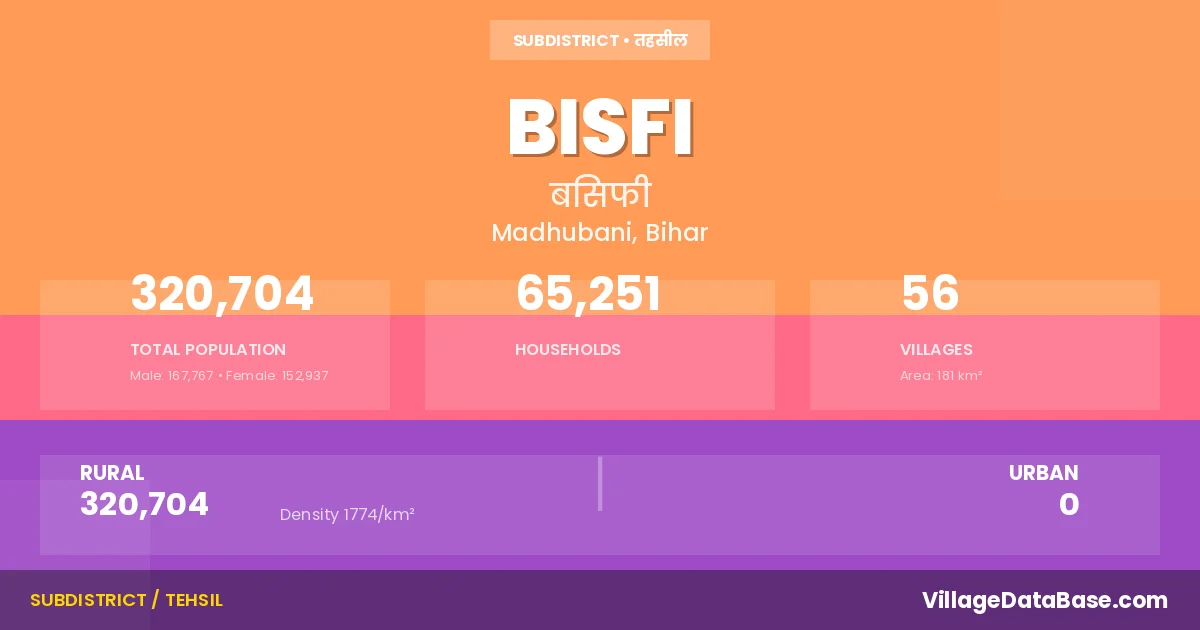
Bisfi is a town and Subdivision in the Madhubani district of the Bihar. In India, a Subdivision is a subdivision of a district responsible for the administration and revenue collection of a specific area within the district. Subdivisions play a crucial role in the local governance structure, contributing significantly to the development and administration of their communities.
According to the 2011 census The total area of Bisfi Subdivision is 181 km², with a population of 320704 people. The population density is 1,774 inhabitants per square kilometre, and there are approximately 65251 houses in the sub district.
Bisfi Subdivision comprises about 56 villages. Below is a list of these villages along with information about their respective gram panchayats and the nearest town:
| # | Village Name | Gram Panchayat | Nearest Town |
|---|---|---|---|
| 1 | Ajnauli | Nahas Rupauli North | Madhubani (14 km) |
| 2 | Arazi Parsauni | Parsauni North | Bisfi |
| 3 | Arazi Usauth | Raghauli | Bisfi |
| 4 | Aunsi Babhangawan | Aunsi Babhangama North | Madhubani (20 km) |
| 5 | Az Rakbe Jafra | Sohas | Madhubani (15 km) |
| 6 | Baingra | Balha | Madhubani (30 km) |
| 7 | Bajraha | Nahas Rupauli North | Madhubani (20 km) |
| 8 | Balha | Balha | Madhubani (30 km) |
| 9 | Bardaha | Jagban West | Madhubani (28 km) |
| 10 | Belaunja | Jafra | Madhubani (15 km) |
| 11 | Bhagauti | Khairi Banka North | Madhubani (27 km) |
| 12 | Bherwa | Bhairba | Madhubani (12 km) |
| 13 | Bhoj Paraul | Bhoj Pandaul | Madhubani (15 km) |
| 14 | Bisfi | Balha | Madhubani (10 km) |
| 15 | Chahuta | Chahuta | Darbhanga (25 km) |
| 16 | Chandarbana | Singaso | Madhubani (20 km) |
| 17 | Chaparia | Khairi Banka South | Madhubani (25 km) |
| 18 | Damla | Bhairba | Madhubani (26 km) |
| 19 | Dhepura | Aunsi Babhangama South | Darbhanga (18 km) |
| 20 | Dudhail | Sadulahpur | Darbhanga (20 km) |
| 21 | Genaur | Nahas Rupauli North | Madhubani (25 km) |
| 22 | Gorhaul | Sadulahpur | Darbhanga (22 km) |
| 23 | Hiropatti | Jagban West | Darbhanga (30 km) |
| 24 | Inamat | Khairi Banka North | Bisfi |
| 25 | Jafra | Jafra | Madhubani (15 km) |
| 26 | Jagban | Jagban East | Madhubani (29 km) |
| 27 | Jairampur | Bisfi | |
| 28 | Janipur | Jagban West | Darbhanga (30 km) |
| 29 | Kerwar | Nahas Rupauli North | Madhubani (20 km) |
| 30 | Khairi Banka | Khairi Banka South | Madhubani (20 km) |
| 31 | Madhopur | Jagban West | Madhubani (30 km) |
| 32 | Madhpur | Jagban West | Madhubani (28 km) |
| 33 | Marhia | Khairi Banka North | Madhubani (26 km) |
| 34 | Marwa | Raghauli | Darbhanga (22 km) |
| 35 | Mokadampur | Jafra | Madhubani (15 km) |
| 36 | Nahar Rupauli | Nahas Rupauli North | Madhubani (10 km) |
| 37 | Nurchak | Nurchak | Madhubani (20 km) |
| 38 | Parohi | Tisi Narsam South | Madhubani (25 km) |
| 39 | Parsauni | Parsauni South | Madhubani (22 km) |
| 40 | Patauna | Tisi Narsam South | Madhubani (24 km) |
| 41 | Raghauli | Raghauli | Darbhanga (22 km) |
| 42 | Raghepura | Raghepura | Madhubani (24 km) |
| 43 | Raghopur | Raghepura | Madhubani (15 km) |
| 44 | Rathos | Rathaus | Madhubani (40 km) |
| 45 | Sadullahpur | Sadulahpur | Darbhanga (25 km) |
| 46 | Sakrari | Tisi Narsam South | Madhubani (26 km) |
| 47 | Salempur | Bhoj Pandaul | Madhubani (15 km) |
| 48 | Sarsoti | Jagban West | Madhubani (30 km) |
| 49 | Sibaul | Rathaus | Madhubani (30 km) |
| 50 | Simri | Simri | Madhubani (10 km) |
| 51 | Singhaso | Singia East | Madhubani (25 km) |
| 52 | Singhia | Singia East | Darbhanga (19 km) |
| 53 | Sohans | Sohas | Madhubani (20 km) |
| 54 | Tisi Narsam | Tisi Narsam South | Madhubani (30 km) |
| 55 | Usauth | Raghauli | Darbhanga (18 km) |
| 56 | Usrahi | Parsauni South | Madhubani (25 km) |
The population is distributed between urban and rural areas as follows:
| Particulars | Rural | Urban | Total |
|---|---|---|---|
| Total Population | 320704 | 0 | 320704 |
| Male Population | 167767 | 0 | 167767 |
| Female Population | 152937 | 0 | 152937 | Population Density | 1774 / km² | 1,774 / km² |
The distribution of households in the Bisfi is:
| Rural Households | Urban Households | Total Households |
|---|---|---|
| 65251 | 0 | 65251 |
Q: What is Bisfi?
A: Bisfi is a town and in the Madhubani district of the Bihar.
Q: What is the total area of Bisfi Subdivision?
A: The total area of Bisfi Subdivision is 181 km².
Q: What is the population of Bisfi Subdivision according to the 2011 census?
A: According to the 2011 census, the population of Bisfi Subdivision is 320704.
Q: What is the population density of Bisfi Subdivision?
A: The population density of Bisfi Subdivision is 1,774 inhabitants per square kilometre.
Q: How many houses are there in Bisfi Subdivision?
A: There are approximately 65251 houses in Bisfi Subdivision.
Q: How many villages are there in Bisfi Subdivision?
A: There are about 56 villages in Bisfi Subdivision.
Q: Which is the largest village by population in Bisfi Subdivision?
A: The largest village by population in Bisfi Subdivision is Parsauni, with 22445 people.
Q: Which is the smallest village by population in Bisfi Subdivision?
A: The smallest village by population in Bisfi Subdivision is Arazi Parsauni, with 0 people.
Q: Which is the largest village by area in Bisfi Subdivision?
A: The largest village by area in Bisfi Subdivision is Singhia, with 1480 km².
Q: Which is the smallest village by area in Bisfi Subdivision?
A: The smallest village by area in Bisfi Subdivision is Inamat, with 9 km².
Q: What is the population distribution between urban and rural areas in Bisfi Subdivision?
A: The population distribution in Bisfi Subdivision is entirely rural, with a total rural population of 320704.
Q: What is the male population of Bisfi Subdivision?
A: The male population of Bisfi Subdivision is 167767.
Q: What is the female population of Bisfi Subdivision?
A: The female population of Bisfi Subdivision is 152937.
Q: How is the household distribution in Bisfi Subdivision?
A: The household distribution in Bisfi Subdivision is entirely rural, with a total of 65251 households.
Q: How many villages in Bisfi Subdivision have a population of less than 100?
A: There are 4 villages in Bisfi Subdivision with a population of less than 100.
Q: How many villages in Bisfi Subdivision have a population between 100 and 499?
A: There are 2 villages in Bisfi Subdivision with a population between 100 and 499.
Q: How many villages in Bisfi Subdivision have a population between 500 and 999?
A: There are 2 villages in Bisfi Subdivision with a population between 500 and 999.
Q: How many villages in Bisfi Subdivision have a population between 1000 and 1999?
A: There are 7 villages in Bisfi Subdivision with a population between 1000 and 1999.
Q: How many villages in Bisfi Subdivision have a population between 2000 and 2999?
A: There is 8 village in Bisfi Subdivision with a population between 2000 and 2999.
Q: How many villages in Bisfi Subdivision have a population between 3000 and 3999?
A: There is 4 village in Bisfi Subdivision with a population between 3000 and 3999.
Q: How many villages in Bisfi Subdivision have a population between 4000 and 4999?
A: There is 6 village in Bisfi Subdivision with a population between 4000 and 4999.
Q: How many villages in Bisfi Subdivision have a population of 5000 and above?
A: There is 23 village in Bisfi Subdivision with a population of 5000 and above.
| Total Population | Villages in Sub District Of Bisfi |
|---|---|
| Less than 100 | 4 |
| 100-499 | 2 |
| 500-999 | 2 |
| 1000-1999 | 7 |
| 2000-2999 | 8 |
| 3000-3999 | 4 |
| 4000-4999 | 6 |
| 5000 And Above | 23 |