Pandaul: A Town and Subdivision in Madhubani district
District → Madhubani
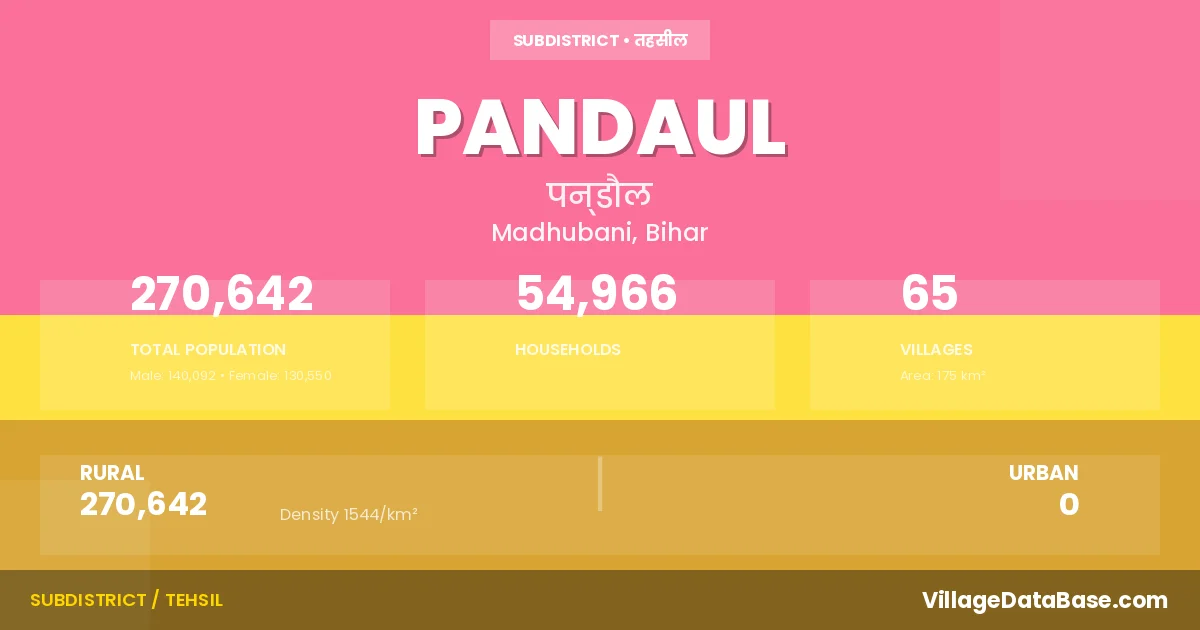
State → Bihar
Pandaul is a town and Subdivision in the Madhubani district of the Bihar. In India, a Subdivision is a subdivision of a district responsible for the administration and revenue collection of a specific area within the district. Subdivisions play a crucial role in the local governance structure, contributing significantly to the development and administration of their communities.
According to the 2011 census The total area of Pandaul Subdivision is 175 km², with a population of 270642 people. The population density is 1,544 inhabitants per square kilometre, and there are approximately 54966 houses in the sub district.
Pandaul Subdivision comprises about 65 villages. Below is a list of these villages along with information about their respective gram panchayats and the nearest town:
| # | Village Name | Gram Panchayat | Nearest Town |
|---|---|---|---|
| 1 | Ajodhya | Sagarpur | Madhubani (15 km) |
| 2 | Andah | Sripurhati N | Madhubani (20 km) |
| 3 | Arazi Bhaur | Bhaur | Pandaul |
| 4 | Arazi Bhawanipur | Bhawanipur | Pandaul |
| 5 | Arazi Rampur | Bhaur | Pandaul |
| 6 | Az Rakbe Nawhath | Sripurhati M | Madhubani (12 km) |
| 7 | Bagban | Pachadhi | Madhubani (20 km) |
| 8 | Bahengra | Sakri East | Madhubani (18 km) |
| 9 | Baluaha | Bhagwatipur | Madhubani (15 km) |
| 10 | Baraghoria | Biraul | Madhubani (18 km) |
| 11 | Bathne | Bathne | Madhubani (8 km) |
| 12 | Baturc | Pachadhi | Madhubani (21 km) |
| 13 | Belahi | Belahi | Madhubani (12 km) |
| 14 | Bhagwatipur | Bhagwatipur | Madhubani (15 km) |
| 15 | Bhagwatipur Inamat | Bhagwatipur | Pandaul |
| 16 | Bhaur | Sakri East | Madhubani (13 km) |
| 17 | Bhawanipur | Bhawanipur | Madhubani (15 km) |
| 18 | Bhitthi | Dahibat Madhopur E | Madhubani (4 km) |
| 19 | Bihnagar | Biraul | Madhubani (18 km) |
| 20 | Bijai | Salempur | Madhubani (18 km) |
| 21 | Bikrampur Balia | Sakri East | Madhubani (18 km) |
| 22 | Biraul | Biraul | Madhubani (18 km) |
| 23 | Bishunpur Murliahi | Meghaul | Madhubani (20 km) |
| 24 | Dabhari | Sankorth | Madhubani (28 km) |
| 25 | Dahibhat Madhopur | Dahibat Madhopur E | Madhubani (15 km) |
| 26 | Dahibhat Narottam | Dahibat Madhopur E | Madhubani (15 km) |
| 27 | Fatehpur Ekdiha | Belahi | Madhubani (10 km) |
| 28 | Gangauli | Meghaul | Madhubani (25 km) |
| 29 | Gurmha | Pachadhi | Pandaul |
| 30 | Haidarpur | Salempur | Madhubani (18 km) |
| 31 | Harpur | Pachadhi | Madhubani (23 km) |
| 32 | Isahpur | Sarisaw Pahi E | Madhubani (23 km) |
| 33 | Kalyanpur | Meghaul | Madhubani (12 km) |
| 34 | Kamlabari | Belahi | Madhubani (10 km) |
| 35 | Kanakpur | Narpati Nagar | Madhubani (24 km) |
| 36 | Khangaon | Bathne | Madhubani (5 km) |
| 37 | Lachhmipur | Sankorth | Pandaul |
| 38 | Lakshmipur | Sankorth | Madhubani (30 km) |
| 39 | Madhopur | Sankorth | Madhubani (29 km) |
| 40 | Majhaul | Meghaul | Madhubani (20 km) |
| 41 | Makrampur | Makrampur | Madhubani (15 km) |
| 42 | Mohanbariam | Makrampur | Madhubani (24 km) |
| 43 | Mohanpur | Sripurhati N | Madhubani (4 km) |
| 44 | Nahar | Bhagwatipur | Madhubani (12 km) |
| 45 | Narpatnagar | Narpati Nagar | Madhubani (24 km) |
| 46 | Nawhath | Sripurhati M | Madhubani (8 km) |
| 47 | Pacharhi | Pachadhi | Madhubani (20 km) |
| 48 | Pahalbadh | Bhaur | Pandaul |
| 49 | Pandaul | Pandaul East | Madhubani (10 km) |
| 50 | Ramkhetari | Singion | Pandaul |
| 51 | Rampur | Sankorth | Madhubani (27 km) |
| 52 | Ruchaul | Bathne | Madhubani (9 km) |
| 53 | Sagarpur | Sagarpur | Madhubani (15 km) |
| 54 | Sakuri | Sakri East | Madhubani (15 km) |
| 55 | Salempur | Salempur | Madhubani (15 km) |
| 56 | Sankorth | Sankorth | Madhubani (26 km) |
| 57 | Sarso | Sarisaw Pahi E | Madhubani (23 km) |
| 58 | Shankar Sarai | Sankorth | Madhubani (29 km) |
| 59 | Shankarpur | Meghaul | Madhubani (20 km) |
| 60 | Shekhjore | Pachadhi | Pandaul |
| 61 | Shekhpur | Pandaul West | Pandaul |
| 62 | Shubhankarpur | Meghaul | Madhubani (18 km) |
| 63 | Shyampur | Bhaur | Pandaul |
| 64 | Sripur Hati | Sripurhati N | Madhubani (4 km) |
| 65 | Udaypur Bitthwar | Bathne | Madhubani (6 km) |
The population is distributed between urban and rural areas as follows:
| Particulars | Rural | Urban | Total |
|---|---|---|---|
| Total Population | 270642 | 0 | 270642 |
| Male Population | 140092 | 0 | 140092 |
| Female Population | 130550 | 0 | 130550 | Population Density | 1544 / km² | 1,544 / km² |
The distribution of households in the Pandaul is:
| Rural Households | Urban Households | Total Households |
|---|---|---|
| 54966 | 0 | 54966 |
Q: What is Pandaul?
A: Pandaul is a town and in the Madhubani district of the Bihar.
Q: What is the total area of Pandaul Subdivision?
A: The total area of Pandaul Subdivision is 175 km².
Q: What is the population of Pandaul Subdivision according to the 2011 census?
A: According to the 2011 census, the population of Pandaul Subdivision is 270642.
Q: What is the population density of Pandaul Subdivision?
A: The population density of Pandaul Subdivision is 1,544 inhabitants per square kilometre.
Q: How many houses are there in Pandaul Subdivision?
A: There are approximately 54966 houses in Pandaul Subdivision.
Q: How many villages are there in Pandaul Subdivision?
A: There are about 65 villages in Pandaul Subdivision.
Q: Which is the largest village by population in Pandaul Subdivision?
A: The largest village by population in Pandaul Subdivision is Pandaul, with 32689 people.
Q: Which is the smallest village by population in Pandaul Subdivision?
A: The smallest village by population in Pandaul Subdivision is Arazi Bhaur, with 0 people.
Q: Which is the largest village by area in Pandaul Subdivision?
A: The largest village by area in Pandaul Subdivision is Sripur Hati, with 1367 km².
Q: Which is the smallest village by area in Pandaul Subdivision?
A: The smallest village by area in Pandaul Subdivision is Lachhmipur, with 2 km².
Q: What is the population distribution between urban and rural areas in Pandaul Subdivision?
A: The population distribution in Pandaul Subdivision is entirely rural, with a total rural population of 270642.
Q: What is the male population of Pandaul Subdivision?
A: The male population of Pandaul Subdivision is 140092.
Q: What is the female population of Pandaul Subdivision?
A: The female population of Pandaul Subdivision is 130550.
Q: How is the household distribution in Pandaul Subdivision?
A: The household distribution in Pandaul Subdivision is entirely rural, with a total of 54966 households.
Q: How many villages in Pandaul Subdivision have a population of less than 100?
A: There are 13 villages in Pandaul Subdivision with a population of less than 100.
Q: How many villages in Pandaul Subdivision have a population between 100 and 499?
A: There are 8 villages in Pandaul Subdivision with a population between 100 and 499.
Q: How many villages in Pandaul Subdivision have a population between 1000 and 1999?
A: There are 12 villages in Pandaul Subdivision with a population between 1000 and 1999.
Q: How many villages in Pandaul Subdivision have a population between 2000 and 2999?
A: There is 6 village in Pandaul Subdivision with a population between 2000 and 2999.
Q: How many villages in Pandaul Subdivision have a population between 3000 and 3999?
A: There is 5 village in Pandaul Subdivision with a population between 3000 and 3999.
Q: How many villages in Pandaul Subdivision have a population between 4000 and 4999?
A: There is 3 village in Pandaul Subdivision with a population between 4000 and 4999.
Q: How many villages in Pandaul Subdivision have a population of 5000 and above?
A: There is 18 village in Pandaul Subdivision with a population of 5000 and above.
| Total Population | Villages in Sub District Of Pandaul |
|---|---|
| Less than 100 | 13 |
| 100-499 | 8 |
| 1000-1999 | 12 |
| 2000-2999 | 6 |
| 3000-3999 | 5 |
| 4000-4999 | 3 |
| 5000 And Above | 18 |