Asthawan: A Town and Subdivision in Nalanda district
District → Nalanda
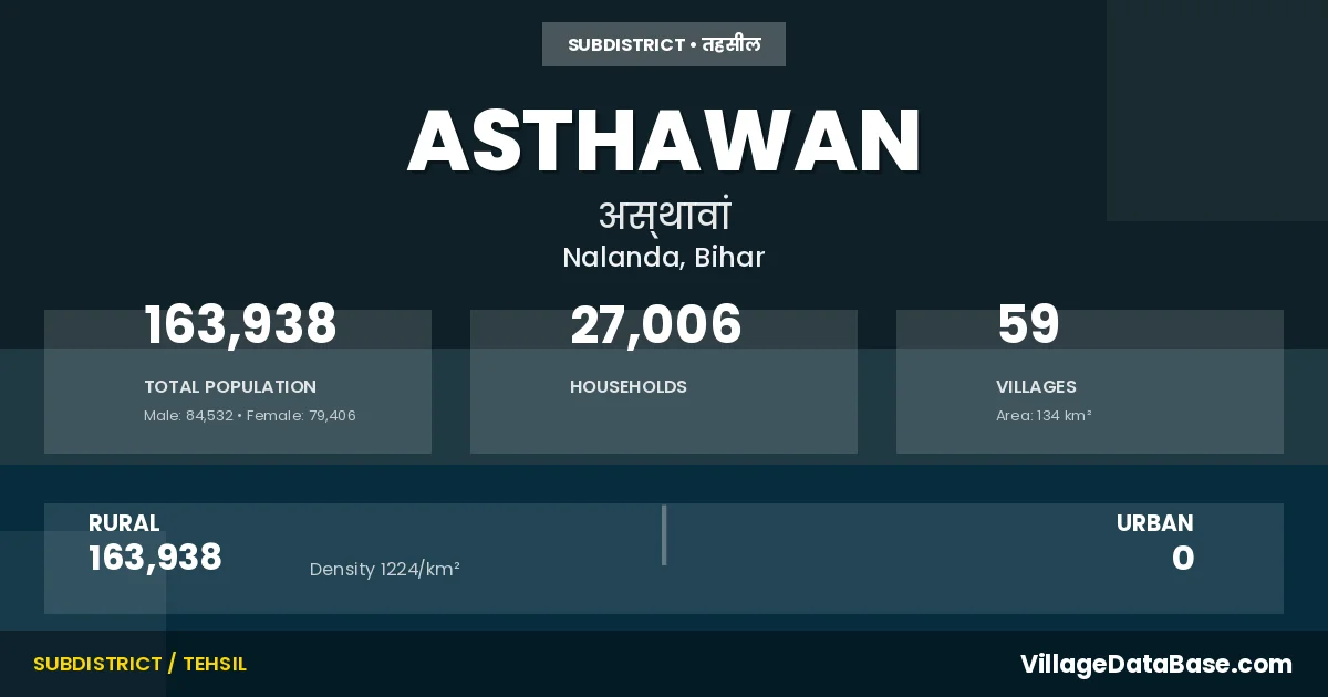
State → Bihar
Asthawan is a town and Subdivision in the Nalanda district of the Bihar. In India, a Subdivision is a subdivision of a district responsible for the administration and revenue collection of a specific area within the district. Subdivisions play a crucial role in the local governance structure, contributing significantly to the development and administration of their communities.
According to the 2011 census The total area of Asthawan Subdivision is 134 km², with a population of 163938 people. The population density is 1,224 inhabitants per square kilometre, and there are approximately 27006 houses in the sub district.
Asthawan Subdivision comprises about 59 villages. Below is a list of these villages along with information about their respective gram panchayats and the nearest town:
| # | Village Name | Gram Panchayat | Nearest Town |
|---|---|---|---|
| 1 | Amanwan | Amanwan | Biharsharif (21 km) |
| 2 | Amba Bigha | Gilani | Biharsharif (25 km) |
| 3 | Andi | Andi | Biharsharif (18 km) |
| 4 | Asthawan | Asthawan | Biharsharif (12 km) |
| 5 | Bahadurpur | Sare | Biharsharif (23 km) |
| 6 | Barepur | Kaila | Biharsharif (18 km) |
| 7 | Bedauli | Murgia Chak | Biharsharif (31 km) |
| 8 | Benar | Amanwan | Biharsharif (16 km) |
| 9 | Bhairo Bigha | Sare | Biharsharif (22 km) |
| 10 | Bhikhani Bigha | Onda | Biharsharif (16 km) |
| 11 | Chakdhi | Dumranwan | Biharsharif (32 km) |
| 12 | Chistipur | Malti | Biharsharif (12 km) |
| 13 | Desna | Andi | Biharsharif (16 km) |
| 14 | Dhobi Bigha | Jana | Biharsharif (15 km) |
| 15 | Dumranwan | Dumranwan | Biharsharif (15 km) |
| 16 | Fatehpur | Kaila | Biharsharif (18 km) |
| 17 | Firozpur | Noanwan | Biharsharif (31 km) |
| 18 | Gilani | Gilani | Biharsharif (25 km) |
| 19 | Gobindpur | Nerut | Biharsharif (25 km) |
| 20 | Gong Chak | Nerut | Biharsharif (25 km) |
| 21 | Harganwan | Gilani | Biharsharif (30 km) |
| 22 | Jagarnathpur | Jana | Biharsharif (12 km) |
| 23 | Jana | Jana | Biharsharif (10 km) |
| 24 | Jangipur | Sare | Biharsharif (22 km) |
| 25 | Jethiar | Dumranwan | Biharsharif (15 km) |
| 26 | Jiar | Jiar | Biharsharif (20 km) |
| 27 | Kaila | Kaila | Biharsharif (17 km) |
| 28 | Kathari | Kathari | Biharsharif (10 km) |
| 29 | Khaje Ahmadpur | Nerut | Biharsharif (24 km) |
| 30 | Khetalpura | Murgia Chak | Biharsharif (24 km) |
| 31 | Khurampur | Konand | Biharsharif (32 km) |
| 32 | Konand | Konand | Biharsharif (32 km) |
| 33 | Kulti | Jiar | Biharsharif (15 km) |
| 34 | Lakhnu Bigha | Uganwan | Biharsharif (32 km) |
| 35 | Madarpur | Oiyav | Biharsharif (25 km) |
| 36 | Mahanandpur | Noanwan | Biharsharif (31 km) |
| 37 | Malanwan | Jana | Biharsharif (12 km) |
| 38 | Malti | Malti | Biharsharif (8 km) |
| 39 | Manpur Amanwan | Amanwan | Biharsharif (19 km) |
| 40 | Mohammadpur Nakatpura | Mahammadpur | Biharsharif (8 km) |
| 41 | Murgia Chak | Murgia Chak | Biharsharif (30 km) |
| 42 | Naurozpur | Murgia Chak | Biharsharif (35 km) |
| 43 | Nerut | Nerut | Biharsharif (25 km) |
| 44 | Nezampur | Kathari | Biharsharif (12 km) |
| 45 | Noanwan | Noanwan | Biharsharif (32 km) |
| 46 | Onda | Onda | Biharsharif (16 km) |
| 47 | Pachetan | Andi | Biharsharif (14 km) |
| 48 | Pasaurha | Kathari | Biharsharif (12 km) |
| 49 | Piprapur | Jana | Biharsharif (12 km) |
| 50 | Rajawan | Mahammadpur | Biharsharif (8 km) |
| 51 | Rami Bigha | Dumranwan | Biharsharif (15 km) |
| 52 | Sadarpur | Nerut | Biharsharif (26 km) |
| 53 | Sarbahdinagar Jainpura | Kaila | Biharsharif (18 km) |
| 54 | Sare | Sare | Biharsharif (20 km) |
| 55 | Shahbazpur | Dumranwan | Biharsharif (15 km) |
| 56 | Shakranwan | Oiyav | Biharsharif (32 km) |
| 57 | Sherpur | Mahammadpur | Biharsharif (8 km) |
| 58 | Uganwan | Uganwan | Biharsharif (32 km) |
| 59 | Woiao | Oiyav | Biharsharif (32 km) |
The population is distributed between urban and rural areas as follows:
| Particulars | Rural | Urban | Total |
|---|---|---|---|
| Total Population | 163938 | 0 | 163938 |
| Male Population | 84532 | 0 | 84532 |
| Female Population | 79406 | 0 | 79406 | Population Density | 1224 / km² | 1,224 / km² |
The distribution of households in the Asthawan is:
| Rural Households | Urban Households | Total Households |
|---|---|---|
| 27006 | 0 | 27006 |
Q: What is Asthawan?
A: Asthawan is a town and in the Nalanda district of the Bihar.
Q: What is the total area of Asthawan Subdivision?
A: The total area of Asthawan Subdivision is 134 km².
Q: What is the population of Asthawan Subdivision according to the 2011 census?
A: According to the 2011 census, the population of Asthawan Subdivision is 163938.
Q: What is the population density of Asthawan Subdivision?
A: The population density of Asthawan Subdivision is 1,224 inhabitants per square kilometre.
Q: How many houses are there in Asthawan Subdivision?
A: There are approximately 27006 houses in Asthawan Subdivision.
Q: How many villages are there in Asthawan Subdivision?
A: There are about 59 villages in Asthawan Subdivision.
Q: Which is the largest village by population in Asthawan Subdivision?
A: The largest village by population in Asthawan Subdivision is Asthawan, with 14061 people.
Q: Which is the smallest village by population in Asthawan Subdivision?
A: The smallest village by population in Asthawan Subdivision is Khaje Ahmadpur, with 88 people.
Q: Which is the largest village by area in Asthawan Subdivision?
A: The largest village by area in Asthawan Subdivision is Asthawan, with 861 km².
Q: Which is the smallest village by area in Asthawan Subdivision?
A: The smallest village by area in Asthawan Subdivision is Madarpur, with 19 km².
Q: What is the population distribution between urban and rural areas in Asthawan Subdivision?
A: The population distribution in Asthawan Subdivision is entirely rural, with a total rural population of 163938.
Q: What is the male population of Asthawan Subdivision?
A: The male population of Asthawan Subdivision is 84532.
Q: What is the female population of Asthawan Subdivision?
A: The female population of Asthawan Subdivision is 79406.
Q: How is the household distribution in Asthawan Subdivision?
A: The household distribution in Asthawan Subdivision is entirely rural, with a total of 27006 households.
Q: How many villages in Asthawan Subdivision have a population of less than 100?
A: There are 1 villages in Asthawan Subdivision with a population of less than 100.
Q: How many villages in Asthawan Subdivision have a population between 100 and 499?
A: There are 5 villages in Asthawan Subdivision with a population between 100 and 499.
Q: How many villages in Asthawan Subdivision have a population between 500 and 999?
A: There are 6 villages in Asthawan Subdivision with a population between 500 and 999.
Q: How many villages in Asthawan Subdivision have a population between 1000 and 1999?
A: There are 18 villages in Asthawan Subdivision with a population between 1000 and 1999.
Q: How many villages in Asthawan Subdivision have a population between 2000 and 2999?
A: There is 10 village in Asthawan Subdivision with a population between 2000 and 2999.
Q: How many villages in Asthawan Subdivision have a population between 3000 and 3999?
A: There is 7 village in Asthawan Subdivision with a population between 3000 and 3999.
Q: How many villages in Asthawan Subdivision have a population between 4000 and 4999?
A: There is 4 village in Asthawan Subdivision with a population between 4000 and 4999.
Q: How many villages in Asthawan Subdivision have a population of 5000 and above?
A: There is 8 village in Asthawan Subdivision with a population of 5000 and above.
| Total Population | Villages in Sub District Of Asthawan |
|---|---|
| Less than 100 | 1 |
| 100-499 | 5 |
| 500-999 | 6 |
| 1000-1999 | 18 |
| 2000-2999 | 10 |
| 3000-3999 | 7 |
| 4000-4999 | 4 |
| 5000 And Above | 8 |