District → Nalanda
State → Bihar
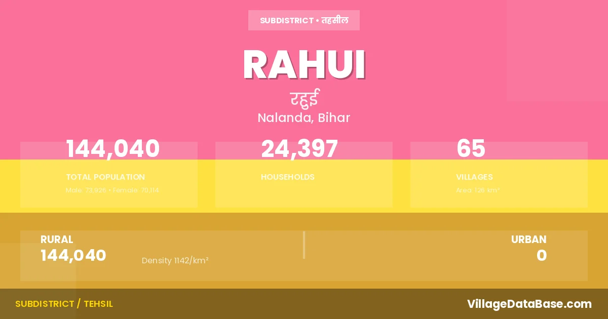
Rahui is a town and Subdivision in the Nalanda district of the Bihar. In India, a Subdivision is a subdivision of a district responsible for the administration and revenue collection of a specific area within the district. Subdivisions play a crucial role in the local governance structure, contributing significantly to the development and administration of their communities.
According to the 2011 census The total area of Rahui Subdivision is 126 km², with a population of 144040 people. The population density is 1,142 inhabitants per square kilometre, and there are approximately 24397 houses in the sub district.
Rahui Subdivision comprises about 65 villages. Below is a list of these villages along with information about their respective gram panchayats and the nearest town:
| # | Village Name | Gram Panchayat | Nearest Town |
|---|---|---|---|
| 1 | Abdulhai Chak | Hawanpura | Biharsharif (20 km) |
| 2 | Amarpur | Patasang | Biharsharif (11 km) |
| 3 | Amba | Amba | Biharsharif (10 km) |
| 4 | Anantpur | Peshaur | Biharsharif (12 km) |
| 5 | Baburbana | Moratalao | Rahui |
| 6 | Baku Chak | Rahui | |
| 7 | Barandi | Barandi | Biharsharif (12 km) |
| 8 | Basak Saidi | Mai Farida | Biharsharif (20 km) |
| 9 | Bazidpur | Supasang | Biharsharif (16 km) |
| 10 | Bhandari | Hawanpura | Biharsharif (16 km) |
| 11 | Bhangan Bigha | Paithna | Biharsharif (11 km) |
| 12 | Bhinda | Sonsa | Biharsharif (18 km) |
| 13 | Chandaura | Supasang | Biharsharif (15 km) |
| 14 | Dehra | Patasang | Biharsharif (10 km) |
| 15 | Dhamauli | Paithna | Biharsharif (12 km) |
| 16 | Dosut | Dosut | Biharsharif (18 km) |
| 17 | Gaibi | Itasang Bhadwa | Biharsharif (5 km) |
| 18 | Gobaria | Patasang | Biharsharif (13 km) |
| 19 | Habanpura | Hawanpura | Biharsharif (13 km) |
| 20 | Hurrahia | Itasang Bhadwa | Biharsharif (4 km) |
| 21 | Hussainpur | Peshaur | Biharsharif (12 km) |
| 22 | Imamganj | Imamganj | Biharsharif (2 km) |
| 23 | Indwas | Hawanpura | Biharsharif (16 km) |
| 24 | Itasan Bhadwa | Itasang Bhadwa | Biharsharif (5 km) |
| 25 | Jahangira | Imamganj | Rahui |
| 26 | Kadi Bigha | Patasang | Biharsharif (10 km) |
| 27 | Kaiampur Makhdumpur | Peshaur | Biharsharif (12 km) |
| 28 | Khaje Sarai | Imamganj | Biharsharif (3 km) |
| 29 | Kumardih | Sosandi | Biharsharif (18 km) |
| 30 | Kutubpura | Supasang | Biharsharif (16 km) |
| 31 | Mai Farida | Mai Farida | Biharsharif (20 km) |
| 32 | Majidpur | Sosandi | Biharsharif (10 km) |
| 33 | Mangrabad | Imamganj | Biharsharif (2 km) |
| 34 | Mararpura | Uttar Nawan | Biharsharif (8 km) |
| 35 | Milki | Amba | Biharsharif (5 km) |
| 36 | Mirzapur | Itasang Bhadwa | Biharsharif (5 km) |
| 37 | Mohammadpur | Peshaur | Biharsharif (15 km) |
| 38 | Mohiuddinpur | Mai Farida | Biharsharif (10 km) |
| 39 | Mora | Dosut | Biharsharif (18 km) |
| 40 | Moratalao | Moratalao | Biharsharif (9 km) |
| 41 | Musepur | Moratalao | Biharsharif (10 km) |
| 42 | Mustafapur | Sonsa | Biharsharif (15 km) |
| 43 | Najai | Sonsa | Biharsharif (18 km) |
| 44 | Ora | Sosandi | Biharsharif (14 km) |
| 45 | Paithna | Paithna | Biharsharif (12 km) |
| 46 | Patasang | Patasang | Biharsharif (8 km) |
| 47 | Peshaur | Peshaur | Biharsharif (12 km) |
| 48 | Phatakpura | Itasang Bhadwa | Rahui |
| 49 | Pichasa | Moratalao | Biharsharif (9 km) |
| 50 | Pitaunjia | Sosandi | Biharsharif (17 km) |
| 51 | Punha | Barandi | Biharsharif (15 km) |
| 52 | Raghopur | Imamganj | Biharsharif (3 km) |
| 53 | Rahui | Rahui | Biharsharif (8 km) |
| 54 | Saraia | Imamganj | Rahui |
| 55 | Shahpur | Patasang | Biharsharif (4 km) |
| 56 | Sherpur | Itasang Bhadwa | Biharsharif (5 km) |
| 57 | Sikandarpur Digpura | Amba | Biharsharif (8 km) |
| 58 | Sonsa | Sonsa | Biharsharif (16 km) |
| 59 | Sonsikra | Sosandi | Biharsharif (18 km) |
| 60 | Sulemanpur | Uttar Nawan | Biharsharif (8 km) |
| 61 | Supasang | Supasang | Biharsharif (18 km) |
| 62 | Susandi | Sosandi | Biharsharif (17 km) |
| 63 | Uphraul | Supasang | Biharsharif (16 km) |
| 64 | Uttarnawan | Uttar Nawan | Biharsharif (12 km) |
| 65 | Wena | Dosut | Biharsharif (18 km) |
The population is distributed between urban and rural areas as follows:
| Particulars | Rural | Urban | Total |
|---|---|---|---|
| Total Population | 144040 | 0 | 144040 |
| Male Population | 73926 | 0 | 73926 |
| Female Population | 70114 | 0 | 70114 | Population Density | 1142 / km² | 1,142 / km² |
The distribution of households in the Rahui is:
| Rural Households | Urban Households | Total Households |
|---|---|---|
| 24397 | 0 | 24397 |
Q: What is Rahui?
A: Rahui is a town and in the Nalanda district of the Bihar.
Q: What is the total area of Rahui Subdivision?
A: The total area of Rahui Subdivision is 126 km².
Q: What is the population of Rahui Subdivision according to the 2011 census?
A: According to the 2011 census, the population of Rahui Subdivision is 144040.
Q: What is the population density of Rahui Subdivision?
A: The population density of Rahui Subdivision is 1,142 inhabitants per square kilometre.
Q: How many houses are there in Rahui Subdivision?
A: There are approximately 24397 houses in Rahui Subdivision.
Q: How many villages are there in Rahui Subdivision?
A: There are about 65 villages in Rahui Subdivision.
Q: Which is the largest village by population in Rahui Subdivision?
A: The largest village by population in Rahui Subdivision is Rahui, with 10687 people.
Q: Which is the smallest village by population in Rahui Subdivision?
A: The smallest village by population in Rahui Subdivision is Baburbana, with 0 people.
Q: Which is the largest village by area in Rahui Subdivision?
A: The largest village by area in Rahui Subdivision is Rahui, with 702 km².
Q: Which is the smallest village by area in Rahui Subdivision?
A: The smallest village by area in Rahui Subdivision is Mangrabad, with 6 km².
Q: What is the population distribution between urban and rural areas in Rahui Subdivision?
A: The population distribution in Rahui Subdivision is entirely rural, with a total rural population of 144040.
Q: What is the male population of Rahui Subdivision?
A: The male population of Rahui Subdivision is 73926.
Q: What is the female population of Rahui Subdivision?
A: The female population of Rahui Subdivision is 70114.
Q: How is the household distribution in Rahui Subdivision?
A: The household distribution in Rahui Subdivision is entirely rural, with a total of 24397 households.
Q: How many villages in Rahui Subdivision have a population of less than 100?
A: There are 6 villages in Rahui Subdivision with a population of less than 100.
Q: How many villages in Rahui Subdivision have a population between 100 and 499?
A: There are 5 villages in Rahui Subdivision with a population between 100 and 499.
Q: How many villages in Rahui Subdivision have a population between 500 and 999?
A: There are 13 villages in Rahui Subdivision with a population between 500 and 999.
Q: How many villages in Rahui Subdivision have a population between 1000 and 1999?
A: There are 17 villages in Rahui Subdivision with a population between 1000 and 1999.
Q: How many villages in Rahui Subdivision have a population between 2000 and 2999?
A: There is 7 village in Rahui Subdivision with a population between 2000 and 2999.
Q: How many villages in Rahui Subdivision have a population between 3000 and 3999?
A: There is 4 village in Rahui Subdivision with a population between 3000 and 3999.
Q: How many villages in Rahui Subdivision have a population between 4000 and 4999?
A: There is 5 village in Rahui Subdivision with a population between 4000 and 4999.
Q: How many villages in Rahui Subdivision have a population of 5000 and above?
A: There is 8 village in Rahui Subdivision with a population of 5000 and above.
| Total Population | Villages in Sub District Of Rahui |
|---|---|
| Less than 100 | 6 |
| 100-499 | 5 |
| 500-999 | 13 |
| 1000-1999 | 17 |
| 2000-2999 | 7 |
| 3000-3999 | 4 |
| 4000-4999 | 5 |
| 5000 And Above | 8 |