District → Nawada
State → Bihar
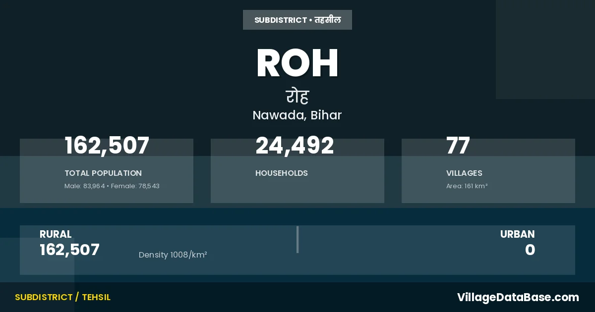
Roh is a town and Subdivision in the Nawada district of the Bihar. In India, a Subdivision is a subdivision of a district responsible for the administration and revenue collection of a specific area within the district. Subdivisions play a crucial role in the local governance structure, contributing significantly to the development and administration of their communities.
According to the 2011 census The total area of Roh Subdivision is 161 km², with a population of 162507 people. The population density is 1,008 inhabitants per square kilometre, and there are approximately 24492 houses in the sub district.
Roh Subdivision comprises about 77 villages. Below is a list of these villages along with information about their respective gram panchayats and the nearest town:
| # | Village Name | Gram Panchayat | Nearest Town |
|---|---|---|---|
| 1 | Adampur | Samahrigadh | Nawada (15 km) |
| 2 | Amba Chak | Madra | Roh |
| 3 | Anaila | Bhatta | Nawada (16 km) |
| 4 | Baghor | Dumari | Nawada (25 km) |
| 5 | Bajwara | Morawan | Nawada (16 km) |
| 6 | Baliari | Koshirukhi | Nawada (18 km) |
| 7 | Bansi Chak | Madra | Nawada (14 km) |
| 8 | Bara | Bhatta | Nawada (24 km) |
| 9 | Bara Chak | Morawan | Nawada (18 km) |
| 10 | Barail | Siur | Nawada (23 km) |
| 11 | Beldhi | Samahrigadh | Nawada (16 km) |
| 12 | Bhandajor | Koshirukhi | Nawada (15 km) |
| 13 | Bhatta | Bhatta | Nawada (20 km) |
| 14 | Bhikhampur | Bhikhanpur | Nawada (22 km) |
| 15 | Binayak | Dumari | Nawada (19 km) |
| 16 | Chhanaun | Chhanaun | Nawada (18 km) |
| 17 | Chorwar | Nazardih | Nawada (10 km) |
| 18 | Dewanag | Chhanaun | Nawada (18 km) |
| 19 | Dewanpura | Ohari | Nawada (10 km) |
| 20 | Dhanawan | Chhanaun | Nawada (20 km) |
| 21 | Dirmo Bara | Kunj | Nawada (18 km) |
| 22 | Duari | Siur | Nawada (31 km) |
| 23 | Dumri | Dumari | Nawada (23 km) |
| 24 | Gayawali Bigha | Samahrigadh | Nawada (16 km) |
| 25 | Ghorahi | Morawan | Nawada (18 km) |
| 26 | Gointhadih | Nazardih | Nawada (10 km) |
| 27 | Gorihari | Koshirukhi | Nawada (18 km) |
| 28 | Hamaza Chak | Nazardih | Nawada (15 km) |
| 29 | Harsidhpur | Koshirukhi | Nawada (17 km) |
| 30 | Isepur | Madra | Nawada (16 km) |
| 31 | Jalalpur | Samahrigadh | Nawada (14 km) |
| 32 | Japhra | Dumari | Nawada (18 km) |
| 33 | Jhakhor | Bhatta | Nawada (25 km) |
| 34 | Karanpur | Dumari | Nawada (23 km) |
| 35 | Karman | Morawan | Nawada (17 km) |
| 36 | Kasmara | Chhanaun | Nawada (19 km) |
| 37 | Katahra | Bhatta | Nawada (20 km) |
| 38 | Kathaun | Dumari | Nawada (22 km) |
| 39 | Kazi Chak | Siur | Nawada (19 km) |
| 40 | Khargu Bigha | Ohari | Nawada (8 km) |
| 41 | Kharij Jaman | Roh | Nawada (13 km) |
| 42 | Khetal Bigha | Nazardih | Roh |
| 43 | Kosirukhi | Koshirukhi | Nawada (23 km) |
| 44 | Kumhrawan | Kunj | Nawada (6 km) |
| 45 | Kunda | Dumari | Nawada (22 km) |
| 46 | Kunj | Kunj | Nawada (5 km) |
| 47 | Kusdihra | Morawan | Nawada (16 km) |
| 48 | Mahrawan | Morawan | Nawada (16 km) |
| 49 | Mahuli | Chhanaun | Nawada (22 km) |
| 50 | Makhdumpur | Madra | Roh |
| 51 | Marra | Madra | Nawada (16 km) |
| 52 | Marui | Marui | Nawada (21 km) |
| 53 | Morawan | Madra | Nawada (17 km) |
| 54 | Nazardih | Nazardih | Nawada (15 km) |
| 55 | Pachamba | Ohari | Nawada (12 km) |
| 56 | Pachghara | Chhanaun | Nawada (21 km) |
| 57 | Pachohya | Ohari | Nawada (10 km) |
| 58 | Paltu Chak | Chhanaun | Roh |
| 59 | Partabpur Nizamat | Bhatta | Nawada (19 km) |
| 60 | Phatna | Nazardih | Nawada (12 km) |
| 61 | Pipra | Morawan | Nawada (15 km) |
| 62 | Pratabpur Jagir | Bhatta | Roh |
| 63 | Pratabpur Khalsa | Bhatta | Nawada (24 km) |
| 64 | Ratoi | Madra | Nawada (16 km) |
| 65 | Roh | Roh | Nawada (12 km) |
| 66 | Rupau | Bhikhanpur | Nawada (21 km) |
| 67 | Rustampur | Samahrigadh | Nawada (12 km) |
| 68 | Sadikpur | Chhanaun | Nawada (21 km) |
| 69 | Samhri | Samahrigadh | Nawada (10 km) |
| 70 | Santhe | Morawan | Nawada (18 km) |
| 71 | Sekharpur | Dumari | Nawada (20 km) |
| 72 | Sheikhpura | Morawan | Nawada (17 km) |
| 73 | Sitapur | Madra | Nawada (12 km) |
| 74 | Siur | Siur | Nawada (23 km) |
| 75 | Tajpur | Kunj | Nawada (12 km) |
| 76 | Telari | Chhanaun | Nawada (18 km) |
| 77 | Wohari | Ohari | Nawada (8 km) |
The population is distributed between urban and rural areas as follows:
| Particulars | Rural | Urban | Total |
|---|---|---|---|
| Total Population | 162507 | 0 | 162507 |
| Male Population | 83964 | 0 | 83964 |
| Female Population | 78543 | 0 | 78543 | Population Density | 1008 / km² | 1,008 / km² |
The distribution of households in the Roh is:
| Rural Households | Urban Households | Total Households |
|---|---|---|
| 24492 | 0 | 24492 |
Q: What is Roh?
A: Roh is a town and in the Nawada district of the Bihar.
Q: What is the total area of Roh Subdivision?
A: The total area of Roh Subdivision is 161 km².
Q: What is the population of Roh Subdivision according to the 2011 census?
A: According to the 2011 census, the population of Roh Subdivision is 162507.
Q: What is the population density of Roh Subdivision?
A: The population density of Roh Subdivision is 1,008 inhabitants per square kilometre.
Q: How many houses are there in Roh Subdivision?
A: There are approximately 24492 houses in Roh Subdivision.
Q: How many villages are there in Roh Subdivision?
A: There are about 77 villages in Roh Subdivision.
Q: Which is the largest village by population in Roh Subdivision?
A: The largest village by population in Roh Subdivision is Marui, with 13723 people.
Q: Which is the smallest village by population in Roh Subdivision?
A: The smallest village by population in Roh Subdivision is Amba Chak, with 0 people.
Q: Which is the largest village by area in Roh Subdivision?
A: The largest village by area in Roh Subdivision is Siur, with 1471 km².
Q: Which is the smallest village by area in Roh Subdivision?
A: The smallest village by area in Roh Subdivision is Pratabpur Jagir, with 25 km².
Q: What is the population distribution between urban and rural areas in Roh Subdivision?
A: The population distribution in Roh Subdivision is entirely rural, with a total rural population of 162507.
Q: What is the male population of Roh Subdivision?
A: The male population of Roh Subdivision is 83964.
Q: What is the female population of Roh Subdivision?
A: The female population of Roh Subdivision is 78543.
Q: How is the household distribution in Roh Subdivision?
A: The household distribution in Roh Subdivision is entirely rural, with a total of 24492 households.
Q: How many villages in Roh Subdivision have a population of less than 100?
A: There are 6 villages in Roh Subdivision with a population of less than 100.
Q: How many villages in Roh Subdivision have a population between 100 and 499?
A: There are 7 villages in Roh Subdivision with a population between 100 and 499.
Q: How many villages in Roh Subdivision have a population between 500 and 999?
A: There are 20 villages in Roh Subdivision with a population between 500 and 999.
Q: How many villages in Roh Subdivision have a population between 1000 and 1999?
A: There are 23 villages in Roh Subdivision with a population between 1000 and 1999.
Q: How many villages in Roh Subdivision have a population between 2000 and 2999?
A: There is 3 village in Roh Subdivision with a population between 2000 and 2999.
Q: How many villages in Roh Subdivision have a population between 3000 and 3999?
A: There is 8 village in Roh Subdivision with a population between 3000 and 3999.
Q: How many villages in Roh Subdivision have a population between 4000 and 4999?
A: There is 3 village in Roh Subdivision with a population between 4000 and 4999.
Q: How many villages in Roh Subdivision have a population of 5000 and above?
A: There is 7 village in Roh Subdivision with a population of 5000 and above.
| Total Population | Villages in Sub District Of Roh |
|---|---|
| Less than 100 | 6 |
| 100-499 | 7 |
| 500-999 | 20 |
| 1000-1999 | 23 |
| 2000-2999 | 3 |
| 3000-3999 | 8 |
| 4000-4999 | 3 |
| 5000 And Above | 7 |