Madhubani: A Town and Subdivision in Pashchim Champaran district
District → Pashchim Champaran
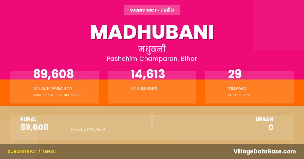
State → Bihar
Madhubani is a town and Subdivision in the Pashchim Champaran district of the Bihar. In India, a Subdivision is a subdivision of a district responsible for the administration and revenue collection of a specific area within the district. Subdivisions play a crucial role in the local governance structure, contributing significantly to the development and administration of their communities.
According to the 2011 census The total area of Madhubani Subdivision is 150 km², with a population of 89608 people. The population density is 596 inhabitants per square kilometre, and there are approximately 14613 houses in the sub district.
Madhubani Subdivision comprises about 29 villages. Below is a list of these villages along with information about their respective gram panchayats and the nearest town:
| # | Village Name | Gram Panchayat | Nearest Town |
|---|---|---|---|
| 1 | Bajar Keraia | Tamkuha | Bagha (75 km) |
| 2 | Baldiha | Sisai | Madhubani |
| 3 | Barwa | Barwa | Bagha (78 km) |
| 4 | Bhandarwa Kalan | Chiurahi | Madhubani |
| 5 | Bhandarwa Majhar | Chiurahi | Bagha (85 km) |
| 6 | Churahi | Chiurahi | Bagha (85 km) |
| 7 | Daunaha | Daunaha | Bagha (78 km) |
| 8 | Dhanaha | Dhanaha | Bagha (84 km) |
| 9 | Ghaghwa | Barwa | Bagha (75 km) |
| 10 | Ghorahwa | Sisai | Bagha (85 km) |
| 11 | Kataha | Tamkuha | Bagha (75 km) |
| 12 | Kolua | Chiurahi | Bagha (90 km) |
| 13 | Kuria | Chiurahi | Madhubani |
| 14 | Madhubani | Madhubani | Bagha (85 km) |
| 15 | Mahuawa | Sisai | Bagha (70 km) |
| 16 | Mathia | Chiurahi | Madhubani |
| 17 | Musahri | Dhanaha | Bagha (84 km) |
| 18 | Nainaha | Chiurahi | Bagha (85 km) |
| 19 | Narahwa | Sisai | Bagha (85 km) |
| 20 | Pakdihwa | Tamkuha | Madhubani |
| 21 | Parari | Chiurahi | Madhubani |
| 22 | Rampur | Dhanaha | Madhubani |
| 23 | Rewahia | Chiurahi | Bagha (86 km) |
| 24 | Sisai Lathihawa | Sisai | Bagha (85 km) |
| 25 | Sohgi Barwa | Sisai | Bagha (80 km) |
| 26 | Tama Kuha | Tamkuha | Bagha (70 km) |
| 27 | Taulaha | Khotahawa | Bagha (75 km) |
| 28 | Tola Musakhar | Chiurahi | Madhubani |
| 29 | Urdabi | Chiurahi | Madhubani |
The population is distributed between urban and rural areas as follows:
| Particulars | Rural | Urban | Total |
|---|---|---|---|
| Total Population | 89608 | 0 | 89608 |
| Male Population | 46879 | 0 | 46879 |
| Female Population | 42729 | 0 | 42729 | Population Density | 596 / km² | 596 / km² |
The distribution of households in the Madhubani is:
| Rural Households | Urban Households | Total Households |
|---|---|---|
| 14613 | 0 | 14613 |
Q: What is Madhubani?
A: Madhubani is a town and in the Pashchim Champaran district of the Bihar.
Q: What is the total area of Madhubani Subdivision?
A: The total area of Madhubani Subdivision is 150 km².
Q: What is the population of Madhubani Subdivision according to the 2011 census?
A: According to the 2011 census, the population of Madhubani Subdivision is 89608.
Q: What is the population density of Madhubani Subdivision?
A: The population density of Madhubani Subdivision is 596 inhabitants per square kilometre.
Q: How many houses are there in Madhubani Subdivision?
A: There are approximately 14613 houses in Madhubani Subdivision.
Q: How many villages are there in Madhubani Subdivision?
A: There are about 29 villages in Madhubani Subdivision.
Q: Which is the largest village by population in Madhubani Subdivision?
A: The largest village by population in Madhubani Subdivision is Taulaha, with 24518 people.
Q: Which is the smallest village by population in Madhubani Subdivision?
A: The smallest village by population in Madhubani Subdivision is Baldiha, with 0 people.
Q: Which is the largest village by area in Madhubani Subdivision?
A: The largest village by area in Madhubani Subdivision is Taulaha, with 2726 km².
Q: Which is the smallest village by area in Madhubani Subdivision?
A: The smallest village by area in Madhubani Subdivision is Baldiha, with 23 km².
Q: What is the population distribution between urban and rural areas in Madhubani Subdivision?
A: The population distribution in Madhubani Subdivision is entirely rural, with a total rural population of 89608.
Q: What is the male population of Madhubani Subdivision?
A: The male population of Madhubani Subdivision is 46879.
Q: What is the female population of Madhubani Subdivision?
A: The female population of Madhubani Subdivision is 42729.
Q: How is the household distribution in Madhubani Subdivision?
A: The household distribution in Madhubani Subdivision is entirely rural, with a total of 14613 households.
Q: How many villages in Madhubani Subdivision have a population of less than 100?
A: There are 10 villages in Madhubani Subdivision with a population of less than 100.
Q: How many villages in Madhubani Subdivision have a population between 100 and 499?
A: There are 6 villages in Madhubani Subdivision with a population between 100 and 499.
Q: How many villages in Madhubani Subdivision have a population between 500 and 999?
A: There are 3 villages in Madhubani Subdivision with a population between 500 and 999.
Q: How many villages in Madhubani Subdivision have a population between 1000 and 1999?
A: There are 2 villages in Madhubani Subdivision with a population between 1000 and 1999.
Q: How many villages in Madhubani Subdivision have a population between 3000 and 3999?
A: There is 1 village in Madhubani Subdivision with a population between 3000 and 3999.
Q: How many villages in Madhubani Subdivision have a population between 4000 and 4999?
A: There is 2 village in Madhubani Subdivision with a population between 4000 and 4999.
Q: How many villages in Madhubani Subdivision have a population of 5000 and above?
A: There is 5 village in Madhubani Subdivision with a population of 5000 and above.
| Total Population | Villages in Sub District Of Madhubani |
|---|---|
| Less than 100 | 10 |
| 100-499 | 6 |
| 500-999 | 3 |
| 1000-1999 | 2 |
| 3000-3999 | 1 |
| 4000-4999 | 2 |
| 5000 And Above | 5 |