Madhuban: A Town and Subdivision in Purba Champaran district
District → Purba Champaran
State → Bihar
Madhuban is a town and Subdivision in the Purba Champaran district of the Bihar. In India, a Subdivision is a subdivision of a district responsible for the administration and revenue collection of a specific area within the district. Subdivisions play a crucial role in the local governance structure, contributing significantly to the development and administration of their communities.
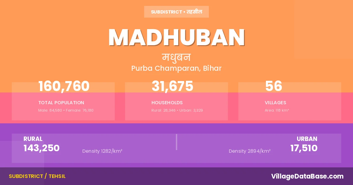
According to the 2011 census The total area of Madhuban Subdivision is 118 km², with a population of 160760 people. The population density is 1,365 inhabitants per square kilometre, and there are approximately 31675 houses in the sub district.
Madhuban Subdivision comprises about 56 villages. Below is a list of these villages along with information about their respective gram panchayats and the nearest town:
| # | Village Name | Gram Panchayat | Nearest Town |
|---|---|---|---|
| 1 | Bahuara | Bajit Par | Madhuban (5 km) |
| 2 | Bajidpur | Bajit Par | Madhuban (3 km) |
| 3 | Banki Tikam | Talimpur | Madhuban (20 km) |
| 4 | Bara Gobind Tola Sawangiya | Sawagia | Madhuban (10 km) |
| 5 | Bara Magru | Karisna Nagra | Madhuban (5 km) |
| 6 | Barhampur | Karisna Nagra | Madhuban (8 km) |
| 7 | Bhagwanpur | Rupni | Madhuban (10 km) |
| 8 | Bijdharia | Sawagia | Madhuban |
| 9 | Chak Chauhani | Garahia | Madhuban (7 km) |
| 10 | Chaube Tola Matalike Jogaulia | Rupni | Madhuban (9 km) |
| 11 | Delho | Koria Kajraha | Madhuban (15 km) |
| 12 | Dubaha Dostia | Karisna Nagra | Madhuban (5 km) |
| 13 | Dulhuma | Dulma | Madhuban (5 km) |
| 14 | Garahia | Garahia | Madhuban (8 km) |
| 15 | Hardiya | Talimpur | Madhuban (20 km) |
| 16 | Harnarayanpur | Garahia | Madhuban (6 km) |
| 17 | Jitaura | Dulma | Madhuban (5 km) |
| 18 | Jogaulia Tola Bhelwa | Bhalwa | Madhuban (6 km) |
| 19 | Jogaulia Tola Chainpur | Nawrangia Madhopur | Madhuban (5 km) |
| 20 | Jogaulia Tola Chitha | Rupni | Madhuban (9 km) |
| 21 | Jogaulia Tola Damaghat | Rupni | Madhuban (10 km) |
| 22 | Jogaulia Tola Gulab Khan | Bhalwa | Madhuban (7 km) |
| 23 | Jogaulia Tola Gurmhia | Rupni | Madhuban (9 km) |
| 24 | Jogaulia Tola Inarwa | Rupni | Madhuban (9 km) |
| 25 | Jogaulia Tola Kasba | Bhalwa | Madhuban (6 km) |
| 26 | Jogaulia Tola Kharsal | Rupni | Madhuban (6 km) |
| 27 | Jogaulia Tola Madhopur | Nawrangia Madhopur | Madhuban (5 km) |
| 28 | Jogaulia Tola Math | Rupni | Madhuban (8 km) |
| 29 | Jogaulia Tola Nandiram Chhapra | Rupni | Madhuban (9 km) |
| 30 | Jogaulia Tola Narayanpur | Nawrangia Madhopur | Madhuban (4 km) |
| 31 | Jogaulia Tola Pakariya | Talimpur | Madhuban (3 km) |
| 32 | Jogaulia Tola Palat | Bhalwa | Madhuban (6 km) |
| 33 | Jogaulia Tola Paterhwa | Sawagia | Madhuban |
| 34 | Jogaulia Tola Ranipur | Nawrangia Madhopur | Madhuban (5 km) |
| 35 | Jogaulia Tola Rupni | Rupni | Madhuban (8 km) |
| 36 | Kajarhan | Koria Kajraha | Madhuban (15 km) |
| 37 | Kauria | Koria Kajraha | Madhuban (15 km) |
| 38 | Khodadpur | Garahia | Madhuban (7 km) |
| 39 | Kishunkara | Karisna Nagra | Madhuban (5 km) |
| 40 | Koilhara | Sawagia | Madhuban (5 km) |
| 41 | Loharganwa | Koilahara | Madhuban (4 km) |
| 42 | Madhuban Tola Dihu | Madhuban South | Madhuban (2 km) |
| 43 | Madhuban Tola Gangapur | Madhuban North | Madhuban (1 km) |
| 44 | Madhuban Tola Koilhara | Koilahara | Madhuban (5 km) |
| 45 | Madhuban Tola Saraia | Madhuban North | Madhuban (3 km) |
| 46 | Madhuban Tola Semra | Koilahara | Madhuban (6 km) |
| 47 | Madhuhan Tola Bhairwa | Koilahara | Madhuban (3 km) |
| 48 | Manpurwa | Bhalwa | Madhuban (6 km) |
| 49 | Maripur Mal | Sawagia | Madhuban (10 km) |
| 50 | Maripur Milik | Sawagia | Madhuban (8 km) |
| 51 | Mogalaniya | Nawrangia Madhopur | Madhuban (5 km) |
| 52 | Nankar Motalike Jogaulia | Rupni | Madhuban (7 km) |
| 53 | Naurangia | Nawrangia Madhopur | Madhuban (4 km) |
| 54 | Punar Murgai Chak | Bajit Par | Madhuban (2 km) |
| 55 | Talimpur | Talimpur | Madhuban (2 km) |
| 56 | Toladih | Nawrangia Madhopur | Madhuban (8 km) |
The population is distributed between urban and rural areas as follows:
| Particulars | Rural | Urban | Total |
|---|---|---|---|
| Total Population | 143250 | 17510 | 160760 |
| Male Population | 75400 | 9180 | 84580 |
| Female Population | 67850 | 8330 | 76180 | Population Density | 1282 / km² | 2894 / km² | 1,365 / km² |
The distribution of households in the Madhuban is:
| Rural Households | Urban Households | Total Households |
|---|---|---|
| 28346 | 3329 | 31675 |
Q: What is Madhuban?
A: Madhuban is a town and in the Purba Champaran district of the Bihar.
Q: What is the total area of Madhuban Subdivision?
A: The total area of Madhuban Subdivision is 118 km².
Q: What is the population of Madhuban Subdivision according to the 2011 census?
A: According to the 2011 census, the population of Madhuban Subdivision is 160760.
Q: What is the population density of Madhuban Subdivision?
A: The population density of Madhuban Subdivision is 1,365 inhabitants per square kilometre.
Q: How many houses are there in Madhuban Subdivision?
A: There are approximately 31675 houses in Madhuban Subdivision.
Q: How many villages are there in Madhuban Subdivision?
A: There are about 56 villages in Madhuban Subdivision.
Q: Which is the largest village by population in Madhuban Subdivision?
A: The largest village by population in Madhuban Subdivision is Kishunkara, with 9716 people.
Q: Which is the smallest village by population in Madhuban Subdivision?
A: The smallest village by population in Madhuban Subdivision is Bijdharia, with 0 people.
Q: Which is the largest village by area in Madhuban Subdivision?
A: The largest village by area in Madhuban Subdivision is Bara Gobind Tola Sawangiya, with 684 km².
Q: Which is the smallest village by area in Madhuban Subdivision?
A: The smallest village by area in Madhuban Subdivision is Madhuban Tola Saraia, with 27 km².
Q: What is the male population of Madhuban Subdivision?
A: The male population of Madhuban Subdivision is 84580.
Q: What is the female population of Madhuban Subdivision?
A: The female population of Madhuban Subdivision is 76180.
Q: How many villages in Madhuban Subdivision have a population of less than 100?
A: There are 3 villages in Madhuban Subdivision with a population of less than 100.
Q: How many villages in Madhuban Subdivision have a population between 100 and 499?
A: There are 4 villages in Madhuban Subdivision with a population between 100 and 499.
Q: How many villages in Madhuban Subdivision have a population between 500 and 999?
A: There are 6 villages in Madhuban Subdivision with a population between 500 and 999.
Q: How many villages in Madhuban Subdivision have a population between 1000 and 1999?
A: There are 14 villages in Madhuban Subdivision with a population between 1000 and 1999.
Q: How many villages in Madhuban Subdivision have a population between 2000 and 2999?
A: There is 11 village in Madhuban Subdivision with a population between 2000 and 2999.
Q: How many villages in Madhuban Subdivision have a population between 3000 and 3999?
A: There is 6 village in Madhuban Subdivision with a population between 3000 and 3999.
Q: How many villages in Madhuban Subdivision have a population between 4000 and 4999?
A: There is 6 village in Madhuban Subdivision with a population between 4000 and 4999.
Q: How many villages in Madhuban Subdivision have a population of 5000 and above?
A: There is 6 village in Madhuban Subdivision with a population of 5000 and above.
| Total Population | Villages in Sub District Of Madhuban |
|---|---|
| Less than 100 | 3 |
| 100-499 | 4 |
| 500-999 | 6 |
| 1000-1999 | 14 |
| 2000-2999 | 11 |
| 3000-3999 | 6 |
| 4000-4999 | 6 |
| 5000 And Above | 6 |