Paharpur: A Town and Subdivision in Purba Champaran district
District → Purba Champaran
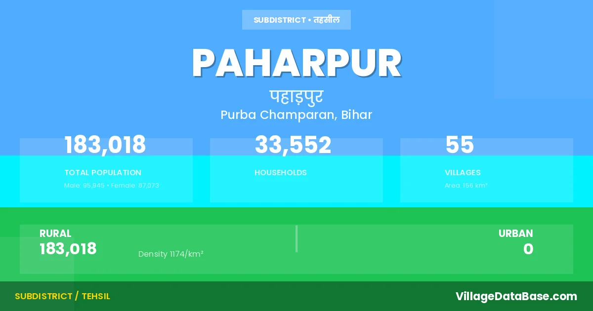
State → Bihar
Paharpur is a town and Subdivision in the Purba Champaran district of the Bihar. In India, a Subdivision is a subdivision of a district responsible for the administration and revenue collection of a specific area within the district. Subdivisions play a crucial role in the local governance structure, contributing significantly to the development and administration of their communities.
According to the 2011 census The total area of Paharpur Subdivision is 156 km², with a population of 183018 people. The population density is 1,174 inhabitants per square kilometre, and there are approximately 33552 houses in the sub district.
Paharpur Subdivision comprises about 55 villages. Below is a list of these villages along with information about their respective gram panchayats and the nearest town:
| # | Village Name | Gram Panchayat | Nearest Town |
|---|---|---|---|
| 1 | Ahiraulia Sonwal | Sonwal | Areraj (17 km) |
| 2 | Ahiraulia Urf Sonwalwakesarea | Sonwal | Areraj (17 km) |
| 3 | Amwa | Parsauni | Areraj (18 km) |
| 4 | Amwa Nizamat | Parsauni | Areraj (17 km) |
| 5 | Arazi Tikuliya | Mankararya | Areraj (11 km) |
| 6 | Baluwa | Balua | Areraj (20 km) |
| 7 | Baluwabirt | Balua | Areraj (20 km) |
| 8 | Bankat | Areraj (20 km) | |
| 9 | Bankatwa | Kamal Pipra | Areraj (7 km) |
| 10 | Barkurwa | Sonwal | Areraj (15 km) |
| 11 | Batraulia | Parsauni | Areraj (3 km) |
| 12 | Bawariya | Siswa West | Areraj (11 km) |
| 13 | Bhanja Chhapra | Parsauni | Areraj (11 km) |
| 14 | Bharwaliya | Majhariya | Areraj (20 km) |
| 15 | Birti Tola | Sareya West | Areraj (18 km) |
| 16 | Bishunpur Matiarwa | Areraj (20 km) | |
| 17 | Dudhiawa | Nawadih | Areraj (18 km) |
| 18 | Ekderwa | Sonwal | Areraj (15 km) |
| 19 | Ganga Pipra | Kamal Pipra | Areraj (10 km) |
| 20 | Gobardhanpur | Kotwa | Areraj (10 km) |
| 21 | Ibrahimpur | Siswa West | Areraj (13 km) |
| 22 | Indarwabhar | Areraj (20 km) | |
| 23 | Inglish | Nawadih | Areraj (18 km) |
| 24 | Kamal Pipra | Kamal Pipra | Areraj (1 km) |
| 25 | Khairwa | Parsauni | Areraj (17 km) |
| 26 | Khairwa Chaube | Tejpurwa | Areraj (17 km) |
| 27 | Kotwa | Kotwa | Areraj (8 km) |
| 28 | Laguniya | Balua | Areraj (20 km) |
| 29 | Lakhmipur | Kotwa | Areraj (10 km) |
| 30 | Laukaha | Mankararya | Areraj (20 km) |
| 31 | Majhariya | Majhariya | Areraj (20 km) |
| 32 | Manguraha | Nawadih | Areraj (30 km) |
| 33 | Mankarariya | Mankararya | Areraj (20 km) |
| 34 | Nauwa Dih | Nawadih | Areraj (18 km) |
| 35 | Naya Ganw | Siswa West | Areraj (13 km) |
| 36 | Nirpur | Kamal Pipra | Areraj (10 km) |
| 37 | Noniya | Noneya South | Areraj (20 km) |
| 38 | Paharpur | Kotwa | Areraj (11 km) |
| 39 | Panditpururf Bandarhelwa | Noneya North | Areraj (20 km) |
| 40 | Parsauni | Parsauni | Areraj (16 km) |
| 41 | Raghunathpur | Noneya North | Areraj (20 km) |
| 42 | Ray Karariya | Siswa West | Areraj (13 km) |
| 43 | Rekha Sarea | Majhariya | Paharpur |
| 44 | Sarea Khas | Sareya West | Areraj (18 km) |
| 45 | Sarea Tola Mathiya | Tejpurwa | Areraj (16 km) |
| 46 | Sarea Tola Senuar | Sareya East | Areraj (18 km) |
| 47 | Sarea Urf Lachhirma Birt Tola | Sareya West | Areraj (18 km) |
| 48 | Sarhangi Chhap | Majhariya | Areraj (18 km) |
| 49 | Siswa | Siswa East | Areraj (12 km) |
| 50 | Sonwal | Sonwal | Areraj (15 km) |
| 51 | Sonwal Ahirauliake Andar | Sonwal | Paharpur |
| 52 | Tejpurwa | Tejpurwa | Areraj (18 km) |
| 53 | Tikuliya | Mankararya | Areraj (13 km) |
| 54 | Tok Bharwaliya | Majhariya | Areraj (20 km) |
| 55 | Wake Rakba Majhariya | Majhariya | Areraj (7 km) |
The population is distributed between urban and rural areas as follows:
| Particulars | Rural | Urban | Total |
|---|---|---|---|
| Total Population | 183018 | 0 | 183018 |
| Male Population | 95945 | 0 | 95945 |
| Female Population | 87073 | 0 | 87073 | Population Density | 1174 / km² | 1,174 / km² |
The distribution of households in the Paharpur is:
| Rural Households | Urban Households | Total Households |
|---|---|---|
| 33552 | 0 | 33552 |
Q: What is Paharpur?
A: Paharpur is a town and in the Purba Champaran district of the Bihar.
Q: What is the total area of Paharpur Subdivision?
A: The total area of Paharpur Subdivision is 156 km².
Q: What is the population of Paharpur Subdivision according to the 2011 census?
A: According to the 2011 census, the population of Paharpur Subdivision is 183018.
Q: What is the population density of Paharpur Subdivision?
A: The population density of Paharpur Subdivision is 1,174 inhabitants per square kilometre.
Q: How many houses are there in Paharpur Subdivision?
A: There are approximately 33552 houses in Paharpur Subdivision.
Q: How many villages are there in Paharpur Subdivision?
A: There are about 55 villages in Paharpur Subdivision.
Q: Which is the largest village by population in Paharpur Subdivision?
A: The largest village by population in Paharpur Subdivision is Sarea Khas, with 22178 people.
Q: Which is the smallest village by population in Paharpur Subdivision?
A: The smallest village by population in Paharpur Subdivision is Rekha Sarea, with 0 people.
Q: Which is the largest village by area in Paharpur Subdivision?
A: The largest village by area in Paharpur Subdivision is Sarea Khas, with 1656 km².
Q: Which is the smallest village by area in Paharpur Subdivision?
A: The smallest village by area in Paharpur Subdivision is Sonwal Ahirauliake Andar, with 2 km².
Q: What is the population distribution between urban and rural areas in Paharpur Subdivision?
A: The population distribution in Paharpur Subdivision is entirely rural, with a total rural population of 183018.
Q: What is the male population of Paharpur Subdivision?
A: The male population of Paharpur Subdivision is 95945.
Q: What is the female population of Paharpur Subdivision?
A: The female population of Paharpur Subdivision is 87073.
Q: How is the household distribution in Paharpur Subdivision?
A: The household distribution in Paharpur Subdivision is entirely rural, with a total of 33552 households.
Q: How many villages in Paharpur Subdivision have a population of less than 100?
A: There are 2 villages in Paharpur Subdivision with a population of less than 100.
Q: How many villages in Paharpur Subdivision have a population between 500 and 999?
A: There are 12 villages in Paharpur Subdivision with a population between 500 and 999.
Q: How many villages in Paharpur Subdivision have a population between 1000 and 1999?
A: There are 15 villages in Paharpur Subdivision with a population between 1000 and 1999.
Q: How many villages in Paharpur Subdivision have a population between 2000 and 2999?
A: There is 9 village in Paharpur Subdivision with a population between 2000 and 2999.
Q: How many villages in Paharpur Subdivision have a population between 3000 and 3999?
A: There is 6 village in Paharpur Subdivision with a population between 3000 and 3999.
Q: How many villages in Paharpur Subdivision have a population between 4000 and 4999?
A: There is 1 village in Paharpur Subdivision with a population between 4000 and 4999.
Q: How many villages in Paharpur Subdivision have a population of 5000 and above?
A: There is 10 village in Paharpur Subdivision with a population of 5000 and above.
| Total Population | Villages in Sub District Of Paharpur |
|---|---|
| Less than 100 | 2 |
| 500-999 | 12 |
| 1000-1999 | 15 |
| 2000-2999 | 9 |
| 3000-3999 | 6 |
| 4000-4999 | 1 |
| 5000 And Above | 10 |