Tetaria: A Town and Subdivision in Purba Champaran district
District → Purba Champaran
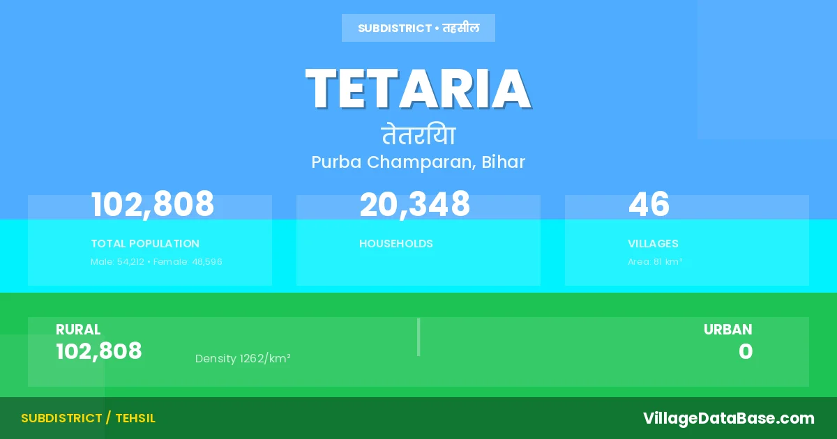
State → Bihar
Tetaria is a town and Subdivision in the Purba Champaran district of the Bihar. In India, a Subdivision is a subdivision of a district responsible for the administration and revenue collection of a specific area within the district. Subdivisions play a crucial role in the local governance structure, contributing significantly to the development and administration of their communities.
According to the 2011 census The total area of Tetaria Subdivision is 81 km², with a population of 102808 people. The population density is 1,262 inhabitants per square kilometre, and there are approximately 20348 houses in the sub district.
Tetaria Subdivision comprises about 46 villages. Below is a list of these villages along with information about their respective gram panchayats and the nearest town:
| # | Village Name | Gram Panchayat | Nearest Town |
|---|---|---|---|
| 1 | Bahuara Gopi Sinh | Bahuara Gopi Singh | Chakia (20 km) |
| 2 | Bahura Ramnarayan Singh | Bahuara Gopi Singh | Chakia (22 km) |
| 3 | Bal Bhadarpur Nankar | Semrahan | Chakia (30 km) |
| 4 | Balbhadarpur | Narhan Panapur | Pakri Dayal (30 km) |
| 5 | Bhagwanpur | Khothiya | Pakri Dayal (23 km) |
| 6 | Bishambharpur Urf Gheghwa | Gheghawa | Chakia (15 km) |
| 7 | Bishunpur Dewajit | Gheghawa | Chakia (8 km) |
| 8 | Chak Chauhani | Punas Lahladpur | Chakia (17 km) |
| 9 | Chheni Chhapra | Meghua | Chakia (35 km) |
| 10 | Dhobwalia | Gheghawa | Chakia (10 km) |
| 11 | Fazilpur | Gheghawa | Chakia (10 km) |
| 12 | Fazilpur Birt | Gheghawa | Chakia (11 km) |
| 13 | Hasanpur | Meghua | Chakia (34 km) |
| 14 | Kadma | Semrahan | Chakia (30 km) |
| 15 | Khairwa | Semrahan | Chakia (25 km) |
| 16 | Kothia | Khothiya | Chakia (30 km) |
| 17 | Lahladpur | Punas Lahladpur | Chakia (35 km) |
| 18 | Madhopur Hari | Tetaria | Chakia (30 km) |
| 19 | Madhuaha Birit | Madhuban Vrit | Chakia (22 km) |
| 20 | Madhuaha Mal | Madhuban Vrit | Chakia (35 km) |
| 21 | Majhuar | Semrahan | Chakia (30 km) |
| 22 | Maniarpur | Bahuara Gopi Singh | Pakri Dayal (35 km) |
| 23 | Manikpur | Punas Lahladpur | Chakia (16 km) |
| 24 | Meghua | Meghua | Chakia (35 km) |
| 25 | Mohammadpur Sagar | Madhuban Vrit | Chakia (23 km) |
| 26 | Molnapur Madhopur | Gheghawa | Motihari (45 km) |
| 27 | Nakardewa | Bahuara Gopi Singh | Pakri Dayal (35 km) |
| 28 | Narayanpur | Semrahan | Chakia (30 km) |
| 29 | Narha Nankar | Narhan Panapur | Pakri Dayal (30 km) |
| 30 | Narha Panapur | Narhan Panapur | Pakri Dayal (35 km) |
| 31 | Padmaul | Semrahan | Chakia (24 km) |
| 32 | Pipra | Bahuara Gopi Singh | Chakia (30 km) |
| 33 | Pipra Makhan | Bahuara Gopi Singh | Pakri Dayal (35 km) |
| 34 | Punas | Punas Lahladpur | Chakia (30 km) |
| 35 | Rohua Man | Bahuara Gopi Singh | Pakri Dayal (35 km) |
| 36 | Sagahri | Meghua | Chakia (36 km) |
| 37 | Saraiya | Meghua | Pakri Dayal (38 km) |
| 38 | Semraha | Semrahan | Chakia (25 km) |
| 39 | Semraha Nankar | Semrahan | Chakia (24 km) |
| 40 | Sirauli | Khothiya | Chakia (30 km) |
| 41 | Sobhitapur | Semrahan | Chakia (22 km) |
| 42 | Sonaul | Bahuara Gopi Singh | Pakri Dayal (35 km) |
| 43 | Sursabad | Bahuara Gopi Singh | Pakri Dayal (35 km) |
| 44 | Tajpur | Tetaria | Chakia (30 km) |
| 45 | Tetaria | Tetaria | Chakia (25 km) |
| 46 | Ujhilpur | Meghua | Chakia (31 km) |
The population is distributed between urban and rural areas as follows:
| Particulars | Rural | Urban | Total |
|---|---|---|---|
| Total Population | 102808 | 0 | 102808 |
| Male Population | 54212 | 0 | 54212 |
| Female Population | 48596 | 0 | 48596 | Population Density | 1262 / km² | 1,262 / km² |
The distribution of households in the Tetaria is:
| Rural Households | Urban Households | Total Households |
|---|---|---|
| 20348 | 0 | 20348 |
Q: What is Tetaria?
A: Tetaria is a town and in the Purba Champaran district of the Bihar.
Q: What is the total area of Tetaria Subdivision?
A: The total area of Tetaria Subdivision is 81 km².
Q: What is the population of Tetaria Subdivision according to the 2011 census?
A: According to the 2011 census, the population of Tetaria Subdivision is 102808.
Q: What is the population density of Tetaria Subdivision?
A: The population density of Tetaria Subdivision is 1,262 inhabitants per square kilometre.
Q: How many houses are there in Tetaria Subdivision?
A: There are approximately 20348 houses in Tetaria Subdivision.
Q: How many villages are there in Tetaria Subdivision?
A: There are about 46 villages in Tetaria Subdivision.
Q: Which is the largest village by population in Tetaria Subdivision?
A: The largest village by population in Tetaria Subdivision is Madhuaha Birit, with 6981 people.
Q: Which is the smallest village by population in Tetaria Subdivision?
A: The smallest village by population in Tetaria Subdivision is Semraha Nankar, with 213 people.
Q: Which is the largest village by area in Tetaria Subdivision?
A: The largest village by area in Tetaria Subdivision is Kothia, with 535 km².
Q: Which is the smallest village by area in Tetaria Subdivision?
A: The smallest village by area in Tetaria Subdivision is Narha Nankar, with 10 km².
Q: What is the population distribution between urban and rural areas in Tetaria Subdivision?
A: The population distribution in Tetaria Subdivision is entirely rural, with a total rural population of 102808.
Q: What is the male population of Tetaria Subdivision?
A: The male population of Tetaria Subdivision is 54212.
Q: What is the female population of Tetaria Subdivision?
A: The female population of Tetaria Subdivision is 48596.
Q: How is the household distribution in Tetaria Subdivision?
A: The household distribution in Tetaria Subdivision is entirely rural, with a total of 20348 households.
Q: How many villages in Tetaria Subdivision have a population between 100 and 499?
A: There are 7 villages in Tetaria Subdivision with a population between 100 and 499.
Q: How many villages in Tetaria Subdivision have a population between 500 and 999?
A: There are 11 villages in Tetaria Subdivision with a population between 500 and 999.
Q: How many villages in Tetaria Subdivision have a population between 1000 and 1999?
A: There are 6 villages in Tetaria Subdivision with a population between 1000 and 1999.
Q: How many villages in Tetaria Subdivision have a population between 2000 and 2999?
A: There is 8 village in Tetaria Subdivision with a population between 2000 and 2999.
Q: How many villages in Tetaria Subdivision have a population between 3000 and 3999?
A: There is 4 village in Tetaria Subdivision with a population between 3000 and 3999.
Q: How many villages in Tetaria Subdivision have a population between 4000 and 4999?
A: There is 6 village in Tetaria Subdivision with a population between 4000 and 4999.
Q: How many villages in Tetaria Subdivision have a population of 5000 and above?
A: There is 4 village in Tetaria Subdivision with a population of 5000 and above.
| Total Population | Villages in Sub District Of Tetaria |
|---|---|
| 100-499 | 7 |
| 500-999 | 11 |
| 1000-1999 | 6 |
| 2000-2999 | 8 |
| 3000-3999 | 4 |
| 4000-4999 | 6 |
| 5000 And Above | 4 |