Barhara: A Town and Subdivision in Purnia district
District → Purnia
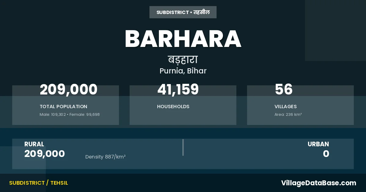
State → Bihar
Barhara is a town and Subdivision in the Purnia district of the Bihar. In India, a Subdivision is a subdivision of a district responsible for the administration and revenue collection of a specific area within the district. Subdivisions play a crucial role in the local governance structure, contributing significantly to the development and administration of their communities.
According to the 2011 census The total area of Barhara Subdivision is 236 km², with a population of 209000 people. The population density is 887 inhabitants per square kilometre, and there are approximately 41159 houses in the sub district.
Barhara Subdivision comprises about 56 villages. Below is a list of these villages along with information about their respective gram panchayats and the nearest town:
| # | Village Name | Gram Panchayat | Nearest Town |
|---|---|---|---|
| 1 | Arbana Chakla | Arbanna Chakala | Banmankhi (18 km) |
| 2 | Auraha Chakla | Aurlaha | Banmankhi (12 km) |
| 3 | Aurahi | Aurahi | Banmankhi (9 km) |
| 4 | Aurahi Milik | Aurahi | Barhara |
| 5 | Bairbana | Basudeopur | Banmankhi (9 km) |
| 6 | Barhara | Aurlaha | Barhara |
| 7 | Barhara Kothi | Basudeopur | Banmankhi (8 km) |
| 8 | Barhara Milik | Barahara | Barhara |
| 9 | Barhari | Barahara | Banmankhi (9 km) |
| 10 | Basdeopur | Basudeopur | Banmankhi (18 km) |
| 11 | Bela Paemu | Gauri Pur | Purnia (40 km) |
| 12 | Bela Paemu Milik | Gauri Pur | Purnia (51 km) |
| 13 | Belaganj | Matihani | Purnia (45 km) |
| 14 | Bhanga Tola | Lataraha | Banmankhi (6 km) |
| 15 | Bhatotar | Sukhsena | Banmankhi (20 km) |
| 16 | Bhatsara | Bhat Sara | Banmankhi (50 km) |
| 17 | Bidanarean | Nathpur | Purnia (65 km) |
| 18 | Bisaharia Got | Laxmi Pur | Purnia (45 km) |
| 19 | Bithaili Dhanpat | Lataraha | Purnia (51 km) |
| 20 | Bithaili Doba | Lataraha | Purnia (51 km) |
| 21 | Bithaili Doba Jagir | Lataraha | Purnia (51 km) |
| 22 | Borhi | Barahara | Banmankhi (8 km) |
| 23 | Chahbacha | Matihani | Purnia (70 km) |
| 24 | Deori | Bhatottar | Banmankhi (45 km) |
| 25 | Dibraghani | Dibra | Purnia (65 km) |
| 26 | Gararia | Tarhi | Banmankhi (10 km) |
| 27 | Gauripur | Gauri Pur | Banmankhi (9 km) |
| 28 | Gauripur Arazi | Gauri Pur | Banmankhi (8 km) |
| 29 | Gauripur Milik | Gauri Pur | Barhara |
| 30 | Hanuman Nagar Chakla | Nathpur | Purnia (60 km) |
| 31 | Harrahi | Basudeopur | Banmankhi (8 km) |
| 32 | Harrahi Milik | Basudeopur | Banmankhi (8 km) |
| 33 | Kamalpur | Mulkiya | Purnia (40 km) |
| 34 | Kamalpur Jagir | Lataraha | Purnia (45 km) |
| 35 | Kamalpur Milik | Mulkiya | Barhara |
| 36 | Latraha | Lataraha | Banmankhi (7 km) |
| 37 | Laukahi | Rustampur | Banmankhi (12 km) |
| 38 | Laukahi Chakla | Rustampur | Banmankhi (10 km) |
| 39 | Magur Jan | Nipania | Banmankhi (4 km) |
| 40 | Magur Jan Milik | Nipania | Banmankhi (14 km) |
| 41 | Maikhand Milik | Laxmi Pur | Purnia (50 km) |
| 42 | Maldiha | Arbanna Chakala | Banmankhi (14 km) |
| 43 | Matihani | Matihani | Purnia (55 km) |
| 44 | Mipania Milik | Nipania | Banmankhi (4 km) |
| 45 | Mulkia | Mulkiya | Purnia (40 km) |
| 46 | Nathpur | Nathpur | Purnia (60 km) |
| 47 | Nipania | Nipania | Banmankhi (8 km) |
| 48 | Nipania Milik | Nipania | Banmankhi (6 km) |
| 49 | Patraha | Patraha | Banmankhi (44 km) |
| 50 | Rustampur | Rustampur | Banmankhi (15 km) |
| 51 | Sahsaul | Mulkiya | Purnia (40 km) |
| 52 | Sukhsena | Sukhsena | Banmankhi (13 km) |
| 53 | Sukhsena Milik | Sukhsena | Banmankhi (13 km) |
| 54 | Thari | Tarhi | Banmankhi (11 km) |
| 55 | Urlaha | Aurlaha | Banmankhi (12 km) |
| 56 | Urlaha Milik | Matihani | Barhara |
The population is distributed between urban and rural areas as follows:
| Particulars | Rural | Urban | Total |
|---|---|---|---|
| Total Population | 209000 | 0 | 209000 |
| Male Population | 109302 | 0 | 109302 |
| Female Population | 99698 | 0 | 99698 | Population Density | 887 / km² | 887 / km² |
The distribution of households in the Barhara is:
| Rural Households | Urban Households | Total Households |
|---|---|---|
| 41159 | 0 | 41159 |
Q: What is Barhara?
A: Barhara is a town and in the Purnia district of the Bihar.
Q: What is the total area of Barhara Subdivision?
A: The total area of Barhara Subdivision is 236 km².
Q: What is the population of Barhara Subdivision according to the 2011 census?
A: According to the 2011 census, the population of Barhara Subdivision is 209000.
Q: What is the population density of Barhara Subdivision?
A: The population density of Barhara Subdivision is 887 inhabitants per square kilometre.
Q: How many houses are there in Barhara Subdivision?
A: There are approximately 41159 houses in Barhara Subdivision.
Q: How many villages are there in Barhara Subdivision?
A: There are about 56 villages in Barhara Subdivision.
Q: Which is the largest village by population in Barhara Subdivision?
A: The largest village by population in Barhara Subdivision is Sukhsena, with 13235 people.
Q: Which is the smallest village by population in Barhara Subdivision?
A: The smallest village by population in Barhara Subdivision is Aurahi Milik, with 0 people.
Q: Which is the largest village by area in Barhara Subdivision?
A: The largest village by area in Barhara Subdivision is Sukhsena, with 1686 km².
Q: Which is the smallest village by area in Barhara Subdivision?
A: The smallest village by area in Barhara Subdivision is Kamalpur Milik, with 0 km².
Q: What is the population distribution between urban and rural areas in Barhara Subdivision?
A: The population distribution in Barhara Subdivision is entirely rural, with a total rural population of 209000.
Q: What is the male population of Barhara Subdivision?
A: The male population of Barhara Subdivision is 109302.
Q: What is the female population of Barhara Subdivision?
A: The female population of Barhara Subdivision is 99698.
Q: How is the household distribution in Barhara Subdivision?
A: The household distribution in Barhara Subdivision is entirely rural, with a total of 41159 households.
Q: How many villages in Barhara Subdivision have a population of less than 100?
A: There are 8 villages in Barhara Subdivision with a population of less than 100.
Q: How many villages in Barhara Subdivision have a population between 100 and 499?
A: There are 6 villages in Barhara Subdivision with a population between 100 and 499.
Q: How many villages in Barhara Subdivision have a population between 500 and 999?
A: There are 9 villages in Barhara Subdivision with a population between 500 and 999.
Q: How many villages in Barhara Subdivision have a population between 1000 and 1999?
A: There are 4 villages in Barhara Subdivision with a population between 1000 and 1999.
Q: How many villages in Barhara Subdivision have a population between 2000 and 2999?
A: There is 2 village in Barhara Subdivision with a population between 2000 and 2999.
Q: How many villages in Barhara Subdivision have a population between 3000 and 3999?
A: There is 5 village in Barhara Subdivision with a population between 3000 and 3999.
Q: How many villages in Barhara Subdivision have a population between 4000 and 4999?
A: There is 3 village in Barhara Subdivision with a population between 4000 and 4999.
Q: How many villages in Barhara Subdivision have a population of 5000 and above?
A: There is 19 village in Barhara Subdivision with a population of 5000 and above.
| Total Population | Villages in Sub District Of Barhara |
|---|---|
| Less than 100 | 8 |
| 100-499 | 6 |
| 500-999 | 9 |
| 1000-1999 | 4 |
| 2000-2999 | 2 |
| 3000-3999 | 5 |
| 4000-4999 | 3 |
| 5000 And Above | 19 |