Bibhutpur: A Town and Subdivision in Samastipur district
District → Samastipur
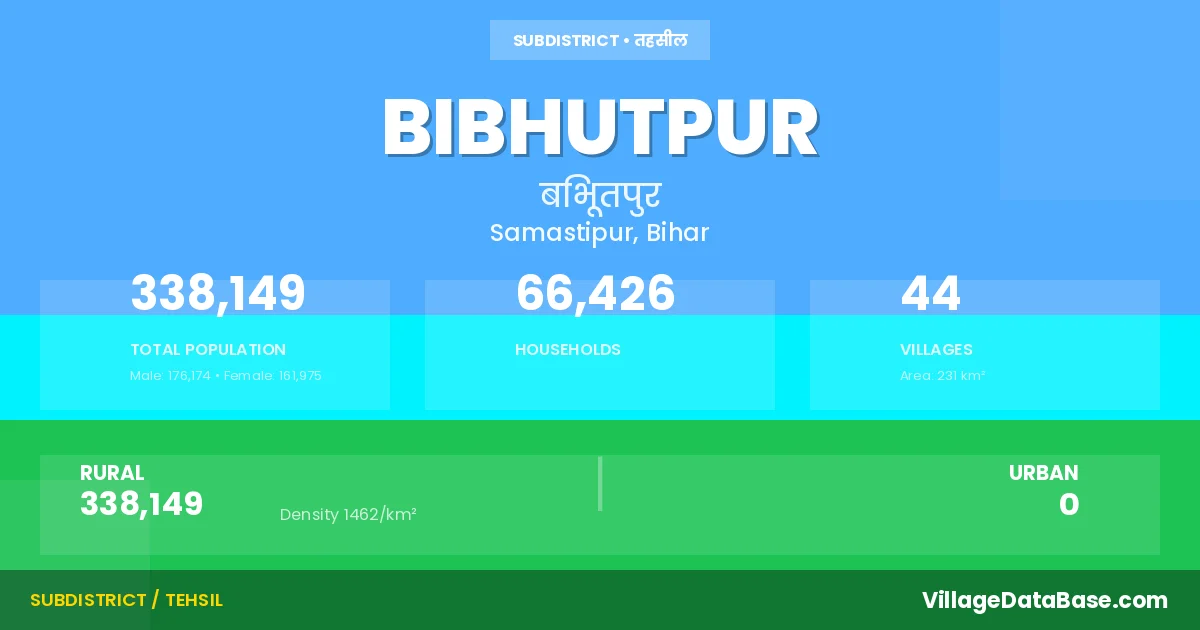
State → Bihar
Bibhutpur is a town and Subdivision in the Samastipur district of the Bihar. In India, a Subdivision is a subdivision of a district responsible for the administration and revenue collection of a specific area within the district. Subdivisions play a crucial role in the local governance structure, contributing significantly to the development and administration of their communities.
According to the 2011 census The total area of Bibhutpur Subdivision is 231 km², with a population of 338149 people. The population density is 1,462 inhabitants per square kilometre, and there are approximately 66426 houses in the sub district.
Bibhutpur Subdivision comprises about 44 villages. Below is a list of these villages along with information about their respective gram panchayats and the nearest town:
| # | Village Name | Gram Panchayat | Nearest Town |
|---|---|---|---|
| 1 | Ajnaul | Mahmadpur Sakra | Bibhutpur |
| 2 | Az Rakbe Mustafapur Bhath | Mushtafapur | Dalsinghsarai (12 km) |
| 3 | Bahlampur Khambhar | Khas Tabhaka South | Dalsinghsarai (11 km) |
| 4 | Balaha | Khas Tabhaka South | Dalsinghsarai (12 km) |
| 5 | Bariarpur | Tabhaka | Dalsinghsarai (15 km) |
| 6 | Bazidpur Bamaia | Bijidpur Bambaiya | Dalsinghsarai (13 km) |
| 7 | Belsandi Dih | Bijidpur Bambaiya | Rosera (7 km) |
| 8 | Belsandi Tara | Belsandi Tara | Rosera (6 km) |
| 9 | Bharpura | Bharpura Patpara | Rosera (10 km) |
| 10 | Bhuswar | Bhuswar | Rosera (17 km) |
| 11 | Bibhutipur | Bibhutipur East | Rosera (9 km) |
| 12 | Boria | Boriya | Rosera (7 km) |
| 13 | Chak Habib | Chak Habib | Dalsinghsarai (8 km) |
| 14 | Chak Hoja | Chak Habib | Dalsinghsarai (8 km) |
| 15 | Chandsurari | Chora Tabhaka | Dalsinghsarai (16 km) |
| 16 | Chora Tabhka | Chora Tabhaka | Dalsinghsarai (14 km) |
| 17 | Damodarpur | Surouli | Dalsinghsarai (10 km) |
| 18 | Desri Urf Sahjahanpur | Desari Karrakh | Dalsinghsarai (26 km) |
| 19 | Gangauli | Gangouli Manda | Rosera (18 km) |
| 20 | Kalyanpur Bamola | Kaliyanpur North | Dalsinghsarai (10 km) |
| 21 | Karakh | Desari Karrakh | Dalsinghsarai (24 km) |
| 22 | Kerai | Kerai | Dalsinghsarai (10 km) |
| 23 | Kishunpur Tabhka | Tabhaka | Dalsinghsarai (16 km) |
| 24 | Kodaria | Alampur Kodaria | Rosera (12 km) |
| 25 | Mahamadpur Shakra | Mahmadpur Sakra | Dalsinghsarai (10 km) |
| 26 | Mahthi | Mahathi South | Rosera (6 km) |
| 27 | Mahthi Tola Alampur | Mahathi South | Rosera (15 km) |
| 28 | Mehsi | Maheshi | Dalsinghsarai (10 km) |
| 29 | Monda | Gangouli Manda | Rosera (20 km) |
| 30 | Mustafapur Bhath | Mushtafapur | Dalsinghsarai (6 km) |
| 31 | Narhan | Narhan | Rosera (19 km) |
| 32 | Patpara | Bharpura Patpara | Rosera (8 km) |
| 33 | Potilia | Patelia | Dalsinghsarai (20 km) |
| 34 | Purkhatimpur Pachhiari | Tabhaka | Dalsinghsarai (14 km) |
| 35 | Raghopur | Tabhaka | Dalsinghsarai (16 km) |
| 36 | Rupauli Khurd | Maheshi | Dalsinghsarai (10 km) |
| 37 | Sakh Mohan | Sakhmohan | Barauni (20 km) |
| 38 | Samartha | Kalyanpur South | Dalsinghsarai (12 km) |
| 39 | Shahpur | Bhuswar | Rosera (19 km) |
| 40 | Shahpur Patohi | Chak Habib | Dalsinghsarai (9 km) |
| 41 | Singhia Buzurg | Singhia Bujurg North | Rosera (9 km) |
| 42 | Surauli | Surouli | Dalsinghsarai (10 km) |
| 43 | Tabhka Khas | Khas Tabhaka North | Dalsinghsarai (16 km) |
| 44 | Tabhka Pachhiari | Chora Tabhaka | Dalsinghsarai (14 km) |
The population is distributed between urban and rural areas as follows:
| Particulars | Rural | Urban | Total |
|---|---|---|---|
| Total Population | 338149 | 0 | 338149 |
| Male Population | 176174 | 0 | 176174 |
| Female Population | 161975 | 0 | 161975 | Population Density | 1462 / km² | 1,462 / km² |
The distribution of households in the Bibhutpur is:
| Rural Households | Urban Households | Total Households |
|---|---|---|
| 66426 | 0 | 66426 |
Q: What is Bibhutpur?
A: Bibhutpur is a town and in the Samastipur district of the Bihar.
Q: What is the total area of Bibhutpur Subdivision?
A: The total area of Bibhutpur Subdivision is 231 km².
Q: What is the population of Bibhutpur Subdivision according to the 2011 census?
A: According to the 2011 census, the population of Bibhutpur Subdivision is 338149.
Q: What is the population density of Bibhutpur Subdivision?
A: The population density of Bibhutpur Subdivision is 1,462 inhabitants per square kilometre.
Q: How many houses are there in Bibhutpur Subdivision?
A: There are approximately 66426 houses in Bibhutpur Subdivision.
Q: How many villages are there in Bibhutpur Subdivision?
A: There are about 44 villages in Bibhutpur Subdivision.
Q: Which is the largest village by population in Bibhutpur Subdivision?
A: The largest village by population in Bibhutpur Subdivision is Bibhutipur, with 34764 people.
Q: Which is the smallest village by population in Bibhutpur Subdivision?
A: The smallest village by population in Bibhutpur Subdivision is Ajnaul, with 0 people.
Q: Which is the largest village by area in Bibhutpur Subdivision?
A: The largest village by area in Bibhutpur Subdivision is Bibhutipur, with 1816 km².
Q: Which is the smallest village by area in Bibhutpur Subdivision?
A: The smallest village by area in Bibhutpur Subdivision is Az Rakbe Mustafapur Bhath, with 19 km².
Q: What is the population distribution between urban and rural areas in Bibhutpur Subdivision?
A: The population distribution in Bibhutpur Subdivision is entirely rural, with a total rural population of 338149.
Q: What is the male population of Bibhutpur Subdivision?
A: The male population of Bibhutpur Subdivision is 176174.
Q: What is the female population of Bibhutpur Subdivision?
A: The female population of Bibhutpur Subdivision is 161975.
Q: How is the household distribution in Bibhutpur Subdivision?
A: The household distribution in Bibhutpur Subdivision is entirely rural, with a total of 66426 households.
Q: How many villages in Bibhutpur Subdivision have a population of less than 100?
A: There are 1 villages in Bibhutpur Subdivision with a population of less than 100.
Q: How many villages in Bibhutpur Subdivision have a population between 100 and 499?
A: There are 3 villages in Bibhutpur Subdivision with a population between 100 and 499.
Q: How many villages in Bibhutpur Subdivision have a population between 500 and 999?
A: There are 1 villages in Bibhutpur Subdivision with a population between 500 and 999.
Q: How many villages in Bibhutpur Subdivision have a population between 1000 and 1999?
A: There are 3 villages in Bibhutpur Subdivision with a population between 1000 and 1999.
Q: How many villages in Bibhutpur Subdivision have a population between 2000 and 2999?
A: There is 2 village in Bibhutpur Subdivision with a population between 2000 and 2999.
Q: How many villages in Bibhutpur Subdivision have a population between 3000 and 3999?
A: There is 4 village in Bibhutpur Subdivision with a population between 3000 and 3999.
Q: How many villages in Bibhutpur Subdivision have a population between 4000 and 4999?
A: There is 5 village in Bibhutpur Subdivision with a population between 4000 and 4999.
Q: How many villages in Bibhutpur Subdivision have a population of 5000 and above?
A: There is 25 village in Bibhutpur Subdivision with a population of 5000 and above.
| Total Population | Villages in Sub District Of Bibhutpur |
|---|---|
| Less than 100 | 1 |
| 100-499 | 3 |
| 500-999 | 1 |
| 1000-1999 | 3 |
| 2000-2999 | 2 |
| 3000-3999 | 4 |
| 4000-4999 | 5 |
| 5000 And Above | 25 |